|
|
|
0 members (),
3,077
guests, and
24
robots. |
|
Key:
Admin,
Global Mod,
Mod
|
|
S |
M |
T |
W |
T |
F |
S |
|
|
|
|
1
|
2
|
3
|
4
|
|
5
|
6
|
7
|
8
|
9
|
10
|
11
|
|
12
|
13
|
14
|
15
|
16
|
17
|
18
|
|
19
|
20
|
21
|
22
|
23
|
24
|
25
|
|
26
|
27
|
28
|
29
|
30
|
31
|
|
|
There are no members with birthdays on this day. |

Volcano earthquake report for Friday, 10 Jul 2026
• Moderate mag. 4.2 earthquake - 133 km northwest of Ternate, Kota Ternate, N...
• World Earthquake Report for Friday, 10 July 2026
• Moderate mag. 4.6 earthquake - 17 km southwest of Comalapa, Estado de Chiap...
• Moderate mag. 4.1 earthquake - Olyutorskiy Rayon, 47 km northwest of Tilich...
• Moderate mag. 4.0 earthquake - Hawke's Bay, New Zealand, on Saturday, Jul 1...
|

#796075
Thu 29 Jan 2026 11:25:PM
|
Joined: Feb 2001
Posts: 678,976
Launch Director
|
OP

Launch Director
Joined: Feb 2001
Posts: 678,976 |
Moderate yet deep magnitude 5.0 earthquake 31 km southwest of Dinaig, Philippines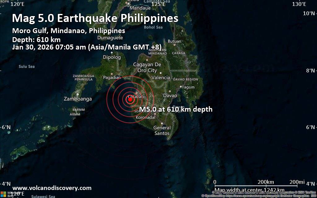 A very deep magnitude 5.0 earthquake was reported in the morning near Dinaig, Maguindanao del Norte, Autonomous Region in Muslim Mindanao, Philippines.
According to the European-Mediterranean Seismological Centre (EMSC), the quake hit on Friday, January 30th, 2026, at 7:05 am local time at a great depth of 610. km. The strength of the earthquake may have been tempered by its relative great depth below the surface, which makes it feel weaker in absolute terms. The exact magnitude, epicenter, and depth of the quake might be revised within the next few hours or minutes as seismologists review data and refine their calculations, or as other agencies issue their report.
Our monitoring service identified a second report from the German Research Centre for Geosciences (GFZ) which listed the quake at magnitude 5.0 as well. Other agencies reporting the same quake include the Philippine Institute of Volcanology and Seismology (PHIVOLCS) at magnitude 4.9, and the citizen-seismograph network of RaspberryShake at magnitude 5.0.
Generally quakes of this magnitude are recorded by more than one agency and the results can vary, with subsequent reports that come in after the first one often showing more accuracy.
According to preliminary calculations, we do not expect that the quake was felt by many people and did not cause any damage. In Rimpeso (pop. 3,500, 13 km away), Dinaig (pop. 116,800, 31 km away), Sultan Kudarat (pop. 125,000, 40 km away), Budta (pop. 1,273,700, 55 km away), Malingao (pop. 1,122,000, 57 km away), Midsayap (pop. 117,400, 64 km away), Isulan (pop. 101,500, 79 km away), Tacurong (pop. 116,900, 83 km away), and Koronadal (pop. 201,800, 109 km away), the quake was probably not felt.
VolcanoDiscovery will automatically update magnitude and depth if these change and follow up if other significant news about the quake become available. If you’re in the area, please send us your experience through our reporting mechanism, either online or via our mobile app. This will help us provide more first-hand updates to anyone around the globe who wants to know more about this quake.
Earthquake data: Date & time: Jan 30, 2026 07:05 am (Manila time) local time (29 Jan 2026 23:05 GMT)Magnitude: 5.0 Depth: 610.00 km Epicenter latitude / longitude: 6.99°N / 123.99°E  (Maguindanao, Autonomous Region in Muslim Mindanao, Philippines) Primary data source: EMSChttps://www.volcanodiscovery.com/earthquake/news/293349/Moderate-yet-deep-magnitude-50-earthquake-31-km-southwest-of-Dinaig-Philippines.html
|
|


CMS The Best Conveyancing solicitors conveyancing quotes throughout the UK
For any webhosting enquiries please email webmaster@aus-city.com
|
|
Entire Thread
|
 Moderate yet deep magnitude 5.0 earthquake 31 km southwest of Dinaig, Philippines
|
Webmaster
|
Thu 29 Jan 2026 11:25:PM
|
|
Forums60
Topics789,860
Posts824,638
Members2,960
| |
Most Online102,106
Jul 10th, 2026
|
|
|
|
|
Copyright 1996 - 2026 by David Cottle. Designed by David Bate Jr. All Rights Reserved.
By using this forum, the user agrees not to transfer any data or technical information received under this agreement to any other entity without the express approval of the AUS-CITY Forum Admins and/or authors of individual posts (Forum Admins and DoD/USSPACECOM for the analysis of satellite tracking data).
Two-line elements (TLE) and all other satellite data presented and distributed via this forum and AUS-CITY mailing lists are distributed with permission from DoD/USSTRATCOM.

|

|


 - Click image for larger picture.")


