|
|
|
1 members (Alisa),
775
guests, and
27
robots. |
|
Key:
Admin,
Global Mod,
Mod
|
|
S |
M |
T |
W |
T |
F |
S |
|
|
|
|
|
|
|
1
|
|
2
|
3
|
4
|
5
|
6
|
7
|
8
|
|
9
|
10
|
11
|
12
|
13
|
14
|
15
|
|
16
|
17
|
18
|
19
|
20
|
21
|
22
|
|
23
|
24
|
25
|
26
|
27
|
28
|
29
|
|
30
|
31
|
|
|
|
|
|
|
There are no members with birthdays on this day. |

Volcano earthquake report for Friday, 31 Jul 2026
• World Earthquake Report for Friday, 31 July 2026
• Light mag. 3.9 earthquake - Philippine Sea, 57 km east of Sulangan, Philipp...
• Small tremor of magnitude 3.1 just reported 10 km southwest of Naples, Ital...
• Seismic-like event, possible earthquake, reported few minutes ago near Napl...
• Strong mag. 5.0 earthquake - 65 km northeast of Pu'er, Yunnan Sheng, China,...
|

#796638
Tue 03 Feb 2026 06:50:AM
|
Joined: Feb 2001
Posts: 678,976
Launch Director
|
OP

Launch Director
Joined: Feb 2001
Posts: 678,976 |
Volcano earthquake report for Tuesday, 3 Feb 2026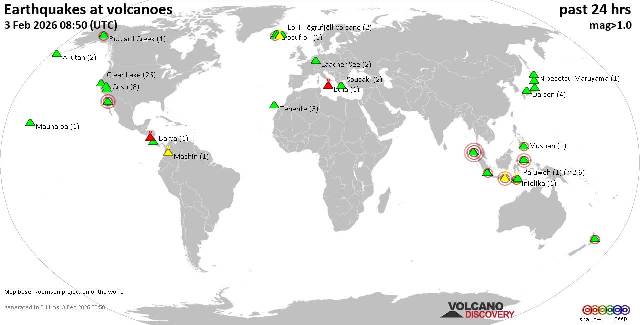 World map showing volcanoes with shallow (less than 50 km) earthquakes within 20 km radius during the past 24 hours on 3 Feb 2026 Number in brackets indicate nr of quakes. Quakes detected near: Akutan (2 quakes between mag 0.3-1.5), Barva (1 quake mag 1.9), Buzzard Creek (1 quake mag 2.0), Clear Lake (23 quakes between mag 0.3-1.4), Coso (7 quakes between mag 0.5-1.8), Daisen (3 quakes between mag 1.0-1.5)
El Chichón (1 quake mag 2.8), Eldey (2 quakes between mag 2.2-2.3), Etna (1 quake mag 1.5), Geureudong (4 quakes between mag 2.1-4.1), Hiuchi (3 quakes between mag 0.8-1.2), Hulubelu (4 quakes between mag 2.0-3.3), Ijen (1 quake mag 3.2), Inielika (1 quake mag 2.2), Isla San Luis (3 quakes between mag 3.3-3.6), Karapinar (1 quake mag 2.0), Katla (2 quakes between mag 0.7-2.5), Ljósufjöll (4 quakes between mag 0.2-1.1), Loki-Fögrufjöll volcano (2 quakes between mag 0.4-1.4), Long Valley (22 quakes between mag 0.7-2.4), Machin (1 quake mag 1.7), Masaya (1 quake mag 1.6), Maunaloa (1 quake mag 1.8), Musuan (1 quake mag 2.0), Nipesotsu-Maruyama (1 quake mag 1.1), Okataina (Tarawera) (1 quake mag 2.4), Osore-yama (1 quake mag 1.0), Paluweh (1 quake mag 2.6), Prestahnukur (1 quake mag 1.3), Soputan (1 quake mag 3.3), Sousaki (2 quakes between mag 1.4-1.5), Suoh (2 quakes between mag 2.2-3.9), Tenerife (3 quakes between mag 1.1-1.2), Thordarhyrna (1 quake mag 1.3), Torfajökull (1 quake mag 1.2) (updated 06h50)
Note: Earthquakes within 20 km from and at depths less than 50 km under active volcanoes are reported. The list is not complete because many volcanoes are not monitored and/or seismic data in high resolution is not available publicly.
Volcanoes with recent earthquakes above magnitude 2 or more than 10 quakes are listed below:
Clear Lake volcano (California): 23 earthquakes up to magnitude 1.4Possible earthquake swarm: 23 earthquakes occurred near (under) the volcano during 23 hours, the last being recorded quake 42 minutes ago. Hypocenter depths ranged between 3.35 and 1.18 km. Earthquake details: (only 5 largest) 1.4 quake 28 mi north of Santa Rosa, Sonoma County, California, United States, Feb 2, 2026 11:57 am (GMT -8) (15 km SSW) 1.3 quake 26 mi north of Santa Rosa, Sonoma County, California, United States, Feb 2, 2026 05:43 am (GMT -8) (18 km SSW) 1.2 quake 27 mi north of Santa Rosa, Sonoma County, California, United States, Feb 1, 2026 10:54 pm (GMT -8) (16 km SSW) 1.2 quake 25 mi north of Santa Rosa, Sonoma County, California, United States, Feb 2, 2026 10:13 am (GMT -8) (19 km S) 1.0 quake 27 mi north of Santa Rosa, Sonoma County, California, United States, Feb 2, 2026 03:21 pm (GMT -8) (18 km SSW) All earthquakes at Clear LakeEl Chichón volcano (Southern Mexico): magnitude 2.8 earthquakeA magnitude 2.8 earthquake occurred at the volcano 24 hours ago. The quake, which might be volcanic in origin, was located at a depth of 3.00 km depth at 1 km distance SSW from the volcano. Earthquake details: 2.8 quake Estado de Chiapas, 38 km southwest of Teapa, Estado de Tabasco, Mexico, Feb 2, 2026 01:03 am (GMT -6) (1 km SSW) All earthquakes at El ChichónEldey volcano (Iceland): 2 earthquakes up to magnitude 2.32 earthquakes occurred near (under) the volcano during 10 minutes, the last being recorded quake 7 hours ago. Hypocenter depths ranged between 10.20 and 9.60 km. Earthquake details: 2.3 quake Iceland: 4.2 km NNW of Eldey Feb 2, 2026 11:46 pm (Reykjavik time) (5 km N) 2.2 quake Iceland: 4.6 km N of Eldey Feb 2, 2026 11:36 pm (Reykjavik time) (6 km NNE) All earthquakes at EldeyEldey is located at the beginning of the Reykjanes Ridge off the SW tip of Iceland. Its highest elevation is the top of Eldey Island, but most of the volcanic edifice is submerged. Several eruptions occurred in historic times, last in 1926. Geureudong volcano (Sumatra): 4 earthquakes up to magnitude 4.14 earthquakes occurred near (under) the volcano during 12 hours, the last being recorded quake 8 hours ago. Hypocenter depths ranged between 10.00 and 7.00 km. Earthquake details: 4.1 quake Kabupaten Aceh Utara, 47 km southwest of Lhokseumawe, Indonesia, Feb 3, 2026 05:38 am (GMT +7) (17 km N) 2.2 quake Kabupaten Aceh Tengah, 66 km southwest of Lhokseumawe, Indonesia, Feb 2, 2026 06:05 pm (GMT +7) (7 km SSW) 2.2 quake Kabupaten Bener Meriah, 61 km southwest of Lhokseumawe, Indonesia, Feb 2, 2026 05:16 pm (GMT +7) (3 km SSW) 2.1 quake Kabupaten Bener Meriah, 54 km south of Bireun, Indonesia, Feb 2, 2026 11:51 pm (GMT +7) (5 km SSW) All earthquakes at GeureudongHulubelu volcano (Sumatra): 4 earthquakes up to magnitude 3.34 earthquakes occurred near (under) the volcano during 4 hours, the last being recorded quake 5 hours ago. Hypocenter depths ranged between 6.00 and 4.00 km. Earthquake details: 3.3 quake Kabupaten Tanggamus, 94 km west of Bandar Lampung, Indonesia, Feb 3, 2026 05:06 am (GMT +7) (18 km W) 2.3 quake Kabupaten Tanggamus, 77 km west of Bandar Lampung, Indonesia, Feb 3, 2026 08:42 am (GMT +7) (8 km S) 2.1 quake Kabupaten Tanggamus, 72 km west of Bandar Lampung, Indonesia, Feb 3, 2026 08:47 am (GMT +7) (6 km SSE) 2.0 quake Kabupaten Tanggamus, 91 km west of Bandar Lampung, Indonesia, Feb 3, 2026 07:42 am (GMT +7) (16 km W) All earthquakes at HulubeluIjen volcano (East Java): magnitude 3.2 earthquakeA magnitude 3.2 earthquake occurred at the volcano 4 hours ago. The quake, which might be volcanic in origin, was located at a depth of 13.00 km depth at 4 km distance NW from the volcano. Earthquake details: 3.2 quake Kabupaten Bondowoso, 27 km northwest of Banyuwangi, Indonesia, Feb 3, 2026 10:08 am (GMT +7) (4 km NW) All earthquakes at IjenInielika volcano (Flores): magnitude 2.2 earthquakeA magnitude 2.2 earthquake occurred at the volcano 18 hours ago. The quake, which might be volcanic in origin, was located at a depth of 10.00 km depth at 5 km distance SSW from the volcano. Earthquake details: 2.2 quake Kabupaten Ngada, 57 km east of Ruteng, Indonesia, Feb 2, 2026 08:28 pm (GMT +8) (5 km SSW) All earthquakes at InielikaIsla San Luis volcano (Baja California, NW Mexico & Mexican Islands): 3 earthquakes up to magnitude 3.63 earthquakes occurred near (under) the volcano during 33 minutes, the last being recorded quake 16 hours ago. Hypocenter depths ranged between 10.00 and 10.00 km. Earthquake details: 3.6 quake 115 km southeast of San Felipe, Estado de Baja California, Mexico, Feb 2, 2026 06:15 am (GMT -8) (11 km N) 3.6 quake 107 km south of San Felipe, Estado de Baja California, Mexico, Feb 2, 2026 05:47 am (GMT -8) (18 km NNW) 3.3 quake 110 km south of San Felipe, Estado de Baja California, Mexico, Feb 2, 2026 06:21 am (GMT -8) (15 km NNW) All earthquakes at Isla San LuisKatla volcano (Iceland): 2 earthquakes up to magnitude 2.52 earthquakes occurred near (under) the volcano during 106 seconds, the last being recorded quake 19 hours ago. Hypocenter depths ranged between 11.70 and 1.00 km. Earthquake details: 2.5 quake 3.4 km NNW of Hábunga Feb 2, 2026 11:22 am (Universal Time) (4 km SW) 0.7 quake Iceland: 4.5 km NW of Hábunga Feb 2, 2026 11:24 am (Reykjavik time) (5 km WSW) All earthquakes at KatlaLong Valley volcano (California): 22 earthquakes up to magnitude 2.4Possible earthquake swarm: 22 earthquakes occurred near (under) the volcano during 7 hours, the last being recorded quake 14 hours ago. Hypocenter depths ranged between 8.34 and 2.30 km. Earthquake details: (only 5 largest) 2.4 quake 7 mi east of Mammoth Lakes, Mono County, California, United States, Feb 2, 2026 02:14 am (GMT -8) (7 km SSE) 1.8 quake 7.1 mi east of Mammoth Lakes, Mono County, California, United States, Feb 2, 2026 02:19 am (GMT -8) (6 km SSE) 1.7 quake 7.7 mi east of Mammoth Lakes, Mono County, California, United States, Feb 2, 2026 02:46 am (GMT -8) (7 km SSE) 1.5 quake 7.1 mi east of Mammoth Lakes, Mono County, California, United States, Feb 2, 2026 02:49 am (GMT -8) (7 km SSE) 1.5 quake 7.2 mi east of Mammoth Lakes, Mono County, California, United States, Feb 2, 2026 02:25 am (GMT -8) (7 km SSE) All earthquakes at Long ValleyOkataina (Tarawera) volcano (New Zealand): magnitude 2.4 earthquakeA magnitude 2.4 earthquake occurred at the volcano 21 hours ago. The quake, which might be volcanic in origin, was located at a depth of 5.90 km depth at 13 km distance SSW from the volcano. Earthquake details: 2.4 quake 21 km southeast of Rotorua, Bay of Plenty, New Zealand, Feb 2, 2026 11:10 pm (GMT +13) (13 km SSW) All earthquakes at Okataina (Tarawera)Paluweh volcano (Lesser Sunda Islands): magnitude 2.6 earthquakeA magnitude 2.6 earthquake occurred at the volcano 8 hours ago. The quake, which might be volcanic in origin, was located at a depth of 15.00 km depth at 10 km distance E from the volcano. Earthquake details: 2.6 quake Flores Sea, 56 km northwest of Maumere, Indonesia, Feb 3, 2026 07:00 am (GMT +8) (10 km E) All earthquakes at PaluwehSoputan volcano (Sulawesi & Sangihe Islands): magnitude 3.3 earthquakeA magnitude 3.3 earthquake occurred at the volcano 17 hours ago. The quake, which might be volcanic in origin, was located at a depth of 19.00 km depth at 17 km distance SE from the volcano. Earthquake details: 3.3 quake Kabupaten Minahasa Tenggara, 55 km south of Manado, Indonesia, Feb 2, 2026 10:02 pm (GMT +8) (17 km SE) All earthquakes at SoputanSuoh volcano (Sumatra): 2 earthquakes up to magnitude 3.92 earthquakes occurred near (under) the volcano during 48 minutes, the last being recorded quake 8 hours ago. Hypocenter depths ranged between 7.00 and 3.00 km. Earthquake details: 3.9 quake Kabupaten Tanggamus, 94 km west of Bandar Lampung, Indonesia, Feb 3, 2026 04:37 am (GMT +7) (17 km ESE) 2.2 quake Kabupaten Tanggamus, 94 km west of Bandar Lampung, Indonesia, Feb 3, 2026 05:25 am (GMT +7) (17 km ESE) All earthquakes at Suoh https://www.volcanodiscovery.com/earthquakes-volcanoes/news/293711/Volcano-earthquake-report-for-Tuesday-3-Feb-2026.html
|
|


CMS The Best Conveyancing solicitors conveyancing quotes throughout the UK
For any webhosting enquiries please email webmaster@aus-city.com
|
|
Entire Thread
|
 Volcano earthquake report for Tuesday, 3 Feb 2026
|
Webmaster
|
Tue 03 Feb 2026 06:50:AM
|
|
Forums60
Topics794,042
Posts828,828
Members2,960
| |
Most Online102,106
Jul 10th, 2026
|
|
|
|
|

|


 - Click image for larger picture.")


