|
|
|
0 members (),
1,981
guests, and
29
robots. |
|
Key:
Admin,
Global Mod,
Mod
|
|
S |
M |
T |
W |
T |
F |
S |
|
|
|
|
1
|
2
|
3
|
4
|
|
5
|
6
|
7
|
8
|
9
|
10
|
11
|
|
12
|
13
|
14
|
15
|
16
|
17
|
18
|
|
19
|
20
|
21
|
22
|
23
|
24
|
25
|
|
26
|
27
|
28
|
29
|
30
|
31
|
|
|
There are no members with birthdays on this day. |
|
|
|
|
|
|
|
|
|
|
|
|
|
|
|
|
|
|
|
|
|
|
by Webmaster - Tue 14 Jul 2026 10:01:PM
|

Volcano earthquake report for Friday, 10 Jul 2026
• Moderate mag. 4.2 earthquake - 133 km northwest of Ternate, Kota Ternate, N...
• World Earthquake Report for Friday, 10 July 2026
• Moderate mag. 4.6 earthquake - 17 km southwest of Comalapa, Estado de Chiap...
• Moderate mag. 4.1 earthquake - Olyutorskiy Rayon, 47 km northwest of Tilich...
• Moderate mag. 4.0 earthquake - Hawke's Bay, New Zealand, on Saturday, Jul 1...
|

#797058
Thu 05 Feb 2026 06:31:PM
|
Joined: Feb 2001
Posts: 678,976
Launch Director
|
OP

Launch Director
Joined: Feb 2001
Posts: 678,976 |
Magnitude 4.9 earthquake strikes near Surigao, Surigao del Norte, Caraga, Philippines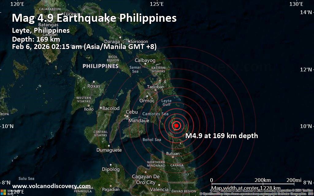 Just 15 minutes ago, a 4.9-magnitude earthquake struck near Surigao, Surigao del Norte, Caraga, Philippines. The tremor was recorded early morning on Friday, February 6th, 2026, at 2:15 am local time, at an intermediate to considerable depth of 169. km below the surface.
The event was filed by the citizen-seismograph network of RaspberryShake, the first seismological agency to report it.
Towns or cities near the epicenter where the quake might have been felt as very weak shaking include Cagdianao (pop. 2,700) located 12 km from the epicenter, Dinagat (pop. 2,600) 14 km away, San Jose (pop. 26,700) 23 km away, Surigao (pop. 87,800) 34 km away, Luna (pop. 7,800) 38 km away, Placer (pop. 10,400) 42 km away, Dapa (pop. 8,800) 48 km away, Maasin (pop. 18,300) 95 km away, and Butuan (pop. 309,700) 120 km away.
VolcanoDiscovery will automatically update magnitude and depth if these change and follow up if other significant news about the quake become available. If you’re in the area, please send us your experience through our reporting mechanism, either online or via our mobile app. This will help us provide more first-hand updates to anyone around the globe who wants to know more about this quake.
Earthquake data: Date & time: Feb 5, 2026 06:15 pm (Universal Time) local time (5 Feb 2026 18:15 GMT)Magnitude: 5.1 Depth: 172.00 km Epicenter latitude / longitude: 9.81°N / 125.62°E  (Dinagat Islands, Caraga, Philippines) Primary data source: GFZhttps://www.volcanodiscovery.com/earthquake/news/294014/Magnitude-49-earthquake-strikes-near-Surigao-Surigao-del-Norte-Caraga-Philippines.html
|
|


CMS The Best Conveyancing solicitors conveyancing quotes throughout the UK
For any webhosting enquiries please email webmaster@aus-city.com
|
|
Entire Thread
|
 Magnitude 4.9 earthquake strikes near Surigao, Surigao del Norte, Caraga, Philippines
|
Webmaster
|
Thu 05 Feb 2026 06:31:PM
|
|
Forums60
Topics788,790
Posts823,565
Members2,960
| |
Most Online102,106
Jul 10th, 2026
|
|
|
|
|
Copyright 1996 - 2026 by David Cottle. Designed by David Bate Jr. All Rights Reserved.
By using this forum, the user agrees not to transfer any data or technical information received under this agreement to any other entity without the express approval of the AUS-CITY Forum Admins and/or authors of individual posts (Forum Admins and DoD/USSPACECOM for the analysis of satellite tracking data).
Two-line elements (TLE) and all other satellite data presented and distributed via this forum and AUS-CITY mailing lists are distributed with permission from DoD/USSTRATCOM.

|

|


 - Click image for larger picture.")


