|
|
|
0 members (),
865
guests, and
22
robots. |
|
Key:
Admin,
Global Mod,
Mod
|
|
S |
M |
T |
W |
T |
F |
S |
|
|
|
|
1
|
2
|
3
|
4
|
|
5
|
6
|
7
|
8
|
9
|
10
|
11
|
|
12
|
13
|
14
|
15
|
16
|
17
|
18
|
|
19
|
20
|
21
|
22
|
23
|
24
|
25
|
|
26
|
27
|
28
|
29
|
30
|
|
|
|
There are no members with birthdays on this day. |

#800913
Tue 03 Mar 2026 06:50:PM
|
Joined: Feb 2001
Posts: 381,904
Launch Director
|
OP

Launch Director
Joined: Feb 2001
Posts: 381,904 |
Volcano earthquake report for Tuesday, 3 Mar 2026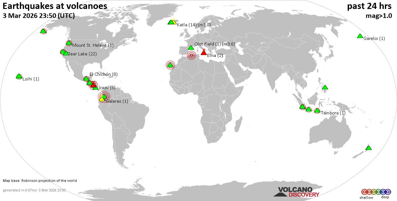 World map showing volcanoes with shallow (less than 50 km) earthquakes within 20 km radius during the past 24 hours on 3 Mar 2026 Number in brackets indicate nr of quakes. Quakes detected near: Apaneca Range (3 quakes between mag 1.4-2.1), Cabalian (2 quakes between mag 1.9-3.1), Cerro Singüil (1 quake mag 2.6), Clear Lake (25 quakes between mag 0.2-2.0), El Chichón (9 quakes between mag 1.8-2.6), Etna (3 quakes between mag 1.0-1.6)
Granada (1 quake mag 3.0), Hulubelu (4 quakes between mag 2.1-2.3), Jailolo (1 quake mag 2.4), Katla (21 quakes between mag 0.0-3.0), Krísuvík (8 quakes between mag 0.0-1.5), Kupreanof (1 quake mag 2.5), Mammoth Mountain (6 quakes between mag 0.3-1.3), Maroa (4 quakes between mag 1.0-1.4), Masaya (1 quake mag 1.8), Maunaloa (2 quakes between mag 1.7-1.8), Mount St. Helens (1 quake mag 2.0), Nevado del Huila (2 quakes between mag 4.0-4.0), Olot Field (1 quake mag 3.6), Reporoa (2 quakes between mag 1.7-2.4), Sekincau Belirang (1 quake mag 2.2), Stepovak Bay 2 (1 quake mag 1.8), Sumbing (1 quake mag 2.1), Tecapa (1 quake mag 3.0), Tenerife (2 quakes between mag 1.5-3.0), Ugashik-Peulik (1 quake mag 1.7), Vesuvius (4 quakes between mag 0.1-1.0) (updated 18h50)
Note: Earthquakes within 20 km from and at depths less than 50 km under active volcanoes are reported. The list is not complete because many volcanoes are not monitored and/or seismic data in high resolution is not available publicly.
Volcanoes with recent earthquakes above magnitude 2 or more than 10 quakes are listed below:
Apaneca Range volcano (El Salvador): 3 earthquakes up to magnitude 2.13 earthquakes occurred near (under) the volcano during 53 minutes, the last being recorded quake 18 hours ago. Hypocenter depths ranged between 8.00 and 4.00 km. Earthquake details: 2.1 quake 18 km north of Sonsonate, Departamento de Sonsonate, El Salvador, Mar 2, 2026 05:59 pm (GMT -6) (7 km ESE) 2.1 quake 17 km north of Sonsonate, Departamento de Sonsonate, El Salvador, Mar 2, 2026 06:52 pm (GMT -6) (8 km ESE) 1.4 quake 18 km north of Sonsonate, Departamento de Sonsonate, El Salvador, Mar 2, 2026 06:49 pm (GMT -6) (5 km ESE) All earthquakes at Apaneca RangeCabalian volcano (Central Philippines): 2 earthquakes up to magnitude 3.12 earthquakes occurred near (under) the volcano during 7 hours, the last being recorded quake 44 minutes ago. Hypocenter depths ranged between 10.00 and 2.00 km. Earthquake details: 3.1 quake Province of Southern Leyte, 51 km east of Inopacan, Philippines, Mar 3, 2026 07:19 pm (GMT +8) (11 km NNW) 1.9 quake Philippine Sea, 22 km northeast of Panaon Island, Philippines, Mar 4, 2026 02:06 am (GMT +8) (16 km SE) All earthquakes at CabalianCerro Singüil volcano (El Salvador): magnitude 2.6 earthquakeA magnitude 2.6 earthquake occurred at the volcano 46 minutes ago. The quake, which might be volcanic in origin, was located at a depth of 4.00 km depth at 14 km distance W from the volcano. Earthquake details: 2.6 quake 13 km northeast of Ahuachapan, Departamento de Ahuachapan, El Salvador, Mar 3, 2026 12:03 pm (GMT -6) (14 km W) All earthquakes at Cerro SingüilClear Lake volcano (California): 25 earthquakes up to magnitude 2.0Possible earthquake swarm: 25 earthquakes occurred near (under) the volcano during 22 hours, the last being recorded quake 1 hour 44 minutes ago. Hypocenter depths ranged between 7.34 and 1.04 km. Earthquake details: (only 5 largest) 2.0 quake Sonoma County, 14 mi southwest of Clearlake, Lake County, California, United States, Mar 3, 2026 03:22 am (GMT -8) (18 km S) 1.5 quake 12 mi southwest of Clearlake, Lake County, California, United States, Mar 2, 2026 05:05 pm (GMT -8) (16 km S) 1.5 quake 25 mi north of Santa Rosa, Sonoma County, California, United States, Mar 3, 2026 01:11 am (GMT -8) (19 km S) 1.5 quake 25 mi north of Santa Rosa, Sonoma County, California, United States, Mar 2, 2026 02:47 pm (GMT -8) (19 km S) 1.2 quake 27 mi north of Santa Rosa, Sonoma County, California, United States, Mar 2, 2026 12:54 pm (GMT -8) (16 km SSW) All earthquakes at Clear LakeEl Chichón volcano (Southern Mexico): 9 earthquakes up to magnitude 2.69 earthquakes occurred near (under) the volcano during 13 hours, the last being recorded quake 8 hours ago. Hypocenter depths ranged between 3.00 and 1.20 km. Earthquake details: (only 5 largest) 2.6 quake Estado de Chiapas, 36 km southwest of Teapa, Estado de Tabasco, Mexico, Mar 2, 2026 03:41 pm (GMT -6) (1 km NNW) 2.4 quake Estado de Chiapas, 37 km southwest of Teapa, Estado de Tabasco, Mexico, Mar 2, 2026 09:35 pm (GMT -6) (1 km NNW) 2.3 quake Estado de Chiapas, 35 km southwest of Teapa, Estado de Tabasco, Mexico, Mar 3, 2026 04:56 am (GMT -6) (2 km NNE) 2.2 quake Estado de Chiapas, 37 km southwest of Teapa, Estado de Tabasco, Mexico, Mar 3, 2026 02:28 am (GMT -6) (1 km SW) 2.2 quake Estado de Chiapas, 37 km southwest of Teapa, Estado de Tabasco, Mexico, Mar 3, 2026 04:55 am (GMT -6) (1 km NNW) All earthquakes at El ChichónGranada volcano (Nicaragua): magnitude 3.0 earthquakeA magnitude 3.0 earthquake occurred at the volcano 9 hours ago. The quake, which might be volcanic in origin, was located at a depth of 10.00 km depth at 4 km distance ENE from the volcano. Earthquake details: Reported seismic-like event (likely no quake): 17 km east of Masaya, Departamento de Masaya, Nicaragua, Mar 3, 2026 03:46 am (GMT -6) (4 km ENE) All earthquakes at GranadaHulubelu volcano (Sumatra): 4 earthquakes up to magnitude 2.34 earthquakes occurred near (under) the volcano during 14 hours, the last being recorded quake 7 hours ago. Hypocenter depths ranged between 11.00 and 4.00 km. Earthquake details: 2.3 quake Kabupaten Tanggamus, 68 km west of Bandar Lampung, Indonesia, Mar 3, 2026 06:25 pm (GMT +7) (11 km SE) 2.2 quake Kabupaten Tanggamus, 65 km west of Bandar Lampung, Indonesia, Mar 3, 2026 06:29 pm (GMT +7) (13 km ESE) 2.2 quake Kabupaten Tanggamus, 89 km west of Bandar Lampung, Indonesia, Mar 3, 2026 06:42 am (GMT +7) (13 km W) 2.1 quake Kabupaten Tanggamus, 90 km west of Bandar Lampung, Indonesia, Mar 3, 2026 04:34 am (GMT +7) (13 km W) All earthquakes at HulubeluJailolo volcano (Halmahera): magnitude 2.4 earthquakeA magnitude 2.4 earthquake occurred at the volcano 20 hours ago. The quake, which might be volcanic in origin, was located at a depth of 12.00 km depth at 8 km distance N from the volcano. Earthquake details: 2.4 quake Maluku Sea, 40 km north of Ternate, Kota Ternate, North Maluku, Indonesia, Mar 3, 2026 07:35 am (GMT +9) (8 km N) All earthquakes at JailoloKatla volcano (Iceland): 21 earthquakes up to magnitude 3.0Possible earthquake swarm: 21 earthquakes occurred near (under) the volcano during 18 hours, the last being recorded quake 6 hours ago. Hypocenter depths ranged between 10.00 and 0.00 km. Earthquake details: (only 5 largest) 3.0 quake 59 km northeast of Vestmannaeyjar, South, Iceland, Mar 3, 2026 06:41 am (Reykjavik time) (6 km W) 1.8 quake 6.0 km ENE of Goðabunga Mar 3, 2026 10:30 am (Universal Time) (6 km NW) 1.6 quake 5.4 km E of Goðabunga Mar 3, 2026 10:27 am (Universal Time) (4 km W) 1.4 quake 3.4 km ENE of Goðabunga Mar 2, 2026 09:13 pm (Universal Time) (7 km WNW) 1.1 quake Iceland: 4.4 km E of Goðabunga Mar 2, 2026 09:09 pm (Reykjavik time) (5 km WNW) All earthquakes at KatlaKupreanof volcano (Alaska Peninsula): magnitude 2.5 earthquakeA magnitude 2.5 earthquake occurred at the volcano 12 hours ago. The quake, which might be volcanic in origin, was located at a depth of 14.55 km depth at 12 km distance ESE from the volcano. Earthquake details: 2.5 quake Lake and Peninsula Borough, 54 mi northeast of Sand Point, Aleutians East Borough, Alaska, United States, Mar 2, 2026 09:28 pm (GMT -9) (12 km ESE) All earthquakes at KupreanofNevado del Huila volcano (Colombia): 2 earthquakes up to magnitude 4.02 earthquakes occurred near (under) the volcano at nearly the same time (12:38 UTC). Hypocenter depths ranged between 1.00 and 1.00 km. Earthquake details: 4.0 quake Departamento del Huila, 31 km north of Belalcazar, Colombia, Mar 3, 2026 07:38 am (GMT -5) (1 km ESE) 4.0 quake Departamento del Huila, 31 km north of Belalcazar, Colombia, Mar 3, 2026 07:38 am (GMT -5) (1 km ESE) All earthquakes at Nevado del HuilaOlot Field volcano (Spain): magnitude 3.6 earthquakeA magnitude 3.6 earthquake occurred at the volcano 1 hour 44 minutes ago. The quake, which might be volcanic in origin, was located at a depth of 1.00 km depth at 6 km distance S from the volcano. Earthquake details: 3.6 quake Wilaya de Blida, 31 km southwest of Algiers, Wilaya d' Alger, Algeria, Mar 3, 2026 06:06 pm (GMT +1) (6 km S) All earthquakes at Olot FieldReporoa volcano (New Zealand): 2 earthquakes up to magnitude 2.42 earthquakes occurred near (under) the volcano during 13 minutes, the last being recorded quake 7 hours ago. Hypocenter depths ranged between 5.00 and 4.20 km. Earthquake details: 2.4 quake 21 km south of Rotorua, Bay of Plenty, New Zealand, Mar 4, 2026 12:57 am (GMT +13) (11 km N) 1.7 quake 23 km south of Rotorua, Bay of Plenty, New Zealand, Mar 4, 2026 01:11 am (GMT +13) (10 km N) All earthquakes at ReporoaSekincau Belirang volcano (Sumatra): magnitude 2.2 earthquakeA magnitude 2.2 earthquake occurred at the volcano 7 hours ago. The quake, which might be volcanic in origin, was located at a depth of 3.00 km depth at 5 km distance S from the volcano. Earthquake details: 2.2 quake Kabupaten Lampung Barat, 109 km west of Bandar Lampung, Indonesia, Mar 3, 2026 06:30 pm (GMT +7) (5 km S) All earthquakes at Sekincau BelirangSumbing volcano (Central Java): magnitude 2.1 earthquakeA magnitude 2.1 earthquake occurred at the volcano 11 hours ago. The quake, which might be volcanic in origin, was located at a depth of 28.00 km depth at 4 km distance SW from the volcano. Earthquake details: 2.1 quake 17 km east of Wonosobo, Kabupaten Wonosobo, Provinsi Jawa Tengah, Indonesia, Mar 3, 2026 02:58 pm (GMT +7) (4 km SW) All earthquakes at SumbingTecapa volcano (El Salvador): magnitude 3.0 earthquakeA magnitude 3.0 earthquake occurred at the volcano 23 hours ago. The quake, which might be volcanic in origin, was located at a depth of 10.00 km depth at 18 km distance N from the volcano. Earthquake details: Reported seismic-like event (likely no quake): 29 km east of San Vicente, Departamento de San Vicente, El Salvador, Mar 2, 2026 01:35 pm (GMT -6) (18 km N) All earthquakes at TecapaTenerife volcano (Canary Islands): 2 earthquakes up to magnitude 3.02 earthquakes occurred near (under) the volcano during 8 minutes, the last being recorded quake 3 hours ago. Hypocenter depths ranged between 16.10 and 10.00 km. Earthquake details: Reported seismic-like event (likely no quake): 27 km west of La Laguna, Santa Cruz de Tenerife, Canary Islands, Spain, Mar 3, 2026 03:36 pm (GMT +0) (16 km NNE) 1.5 quake 35 km southwest of Santa Cruz de Tenerife, Spain, Mar 3, 2026 03:28 pm (Universal Time) (15 km ESE) All earthquakes at Tenerifehttps://www.volcanodiscovery.com/earthquakes-volcanoes/news/296478/Volcano-earthquake-report-for-Tuesday-3-Mar-2026.html
|
|


CMS The Best Conveyancing solicitors conveyancing quotes throughout the UK
For any webhosting enquiries please email webmaster@aus-city.com
|
|
Entire Thread
|
 Volcano earthquake report for Tuesday, 3 Mar 2026
|
Webmaster
|
Tue 03 Mar 2026 06:50:PM
|
|
Forums60
Topics768,980
Posts803,746
Members2,958
| |
Most Online17,963
Jan 15th, 2026
|
|
|
|
|
Copyright 1996 - 2026 by David Cottle. Designed by David Bate Jr. All Rights Reserved.
By using this forum, the user agrees not to transfer any data or technical information received under the agreement, to any other entity without the express approval of the AUS-CITY Forum Admins and/or authors of individual posts (Forum Admins and DoD/USSPACECOM for the analysis of satellite tracking data).
Two-line elements (TLE) and all other satellite data presented and distributed via this forum and e-mail lists of AUS-CITY are distributed with permission from DoD/USSTRATCOM.

Reprise Hosting

|

|


 - Click image for larger picture.")


