|
0 members (),
1,683
guests, and
24
robots. |
|
Key:
Admin,
Global Mod,
Mod
|
|
S |
M |
T |
W |
T |
F |
S |
|
|
|
|
1
|
2
|
3
|
4
|
|
5
|
6
|
7
|
8
|
9
|
10
|
11
|
|
12
|
13
|
14
|
15
|
16
|
17
|
18
|
|
19
|
20
|
21
|
22
|
23
|
24
|
25
|
|
26
|
27
|
28
|
29
|
30
|
31
|
|
|
There are no members with birthdays on this day. |

Volcano earthquake report for Friday, 10 Jul 2026
• Moderate mag. 4.2 earthquake - 133 km northwest of Ternate, Kota Ternate, N...
• World Earthquake Report for Friday, 10 July 2026
• Moderate mag. 4.6 earthquake - 17 km southwest of Comalapa, Estado de Chiap...
• Moderate mag. 4.1 earthquake - Olyutorskiy Rayon, 47 km northwest of Tilich...
• Moderate mag. 4.0 earthquake - Hawke's Bay, New Zealand, on Saturday, Jul 1...
|

#801335
Sat 07 Mar 2026 02:06:AM
|
Joined: Feb 2001
Posts: 678,976
Launch Director
|
OP

Launch Director
Joined: Feb 2001
Posts: 678,976 |
SPC Tornado Watch 15WW 15 TORNADO OK TX 062045Z - 070400Z 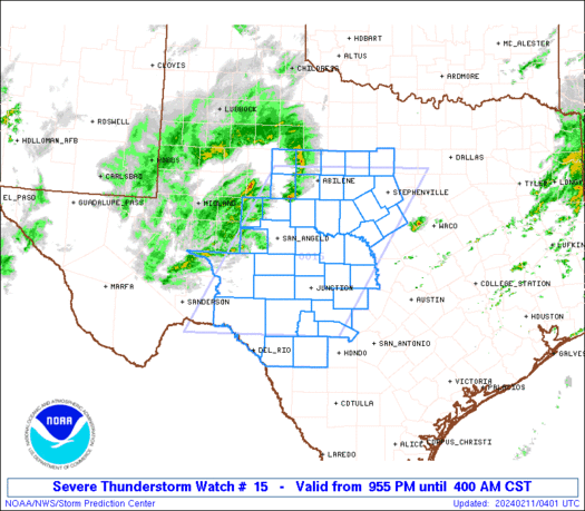
URGENT - IMMEDIATE BROADCAST REQUESTED
Tornado Watch Number 15
NWS Storm Prediction Center Norman OK
245 PM CST Fri Mar 6 2026

The NWS Storm Prediction Center has issued a

* Tornado Watch for portions of
  Central and Eastern Oklahoma
  North Texas

* Effective this Friday afternoon and evening from 245 PM until
  1000 PM CST.

* Primary threats include...
  A few tornadoes and a couple intense tornadoes possible
  Scattered large hail likely with isolated very large hail events
    to 2.5 inches in diameter possible
  Scattered damaging wind gusts to 70 mph possible

SUMMARY...Severe thunderstorms including supercells are expected to
develop through mid/late afternoon across the region, with the most
intense storms capable of large hail, damaging winds, and a tornado
risk.

The tornado watch area is approximately along and 80 statute miles
east and west of a line from 15 miles northeast of Bartlesville OK
to 25 miles southeast of Mineral Wells TX. For a complete depiction
of the watch see the associated watch outline update (WOUS64 KWNS
WOU5).

PRECAUTIONARY/PREPAREDNESS ACTIONS...

REMEMBER...A Tornado Watch means conditions are favorable for
tornadoes and severe thunderstorms in and close to the watch
area. Persons in these areas should be on the lookout for
threatening weather conditions and listen for later statements
and possible warnings.

&&

AVIATION...Tornadoes and a few severe thunderstorms with hail
surface and aloft to 2.5 inches. Extreme turbulence and surface wind
gusts to 60 knots. A few cumulonimbi with maximum tops to 450. Mean
storm motion vector 23025.

...Guyer
Read morehttps://www.spc.noaa.gov/products/watch/ww0015.html
|
|


CMS The Best Conveyancing solicitors conveyancing quotes throughout the UK
For any webhosting enquiries please email webmaster@aus-city.com
|
|
Entire Thread
|
 SPC Tornado Watch 15
|
Webmaster
|
Sat 07 Mar 2026 02:06:AM
|
|
Forums60
Topics787,730
Posts822,504
Members2,960
| |
Most Online102,106
06:57 PM
|
|
|


 - Click image for larger picture.")


