|
1 members (Alisa),
1,642
guests, and
27
robots. |
|
Key:
Admin,
Global Mod,
Mod
|
|
S |
M |
T |
W |
T |
F |
S |
|
|
1
|
2
|
3
|
4
|
5
|
6
|
|
7
|
8
|
9
|
10
|
11
|
12
|
13
|
|
14
|
15
|
16
|
17
|
18
|
19
|
20
|
|
21
|
22
|
23
|
24
|
25
|
26
|
27
|
|
28
|
29
|
30
|
|
|
|
|
|
There are no members with birthdays on this day. |

Magnitude 5.3 earthquake strikes near Palu, Kota Palu, Sulawesi Tengah, Indonesia
• Strong mag. 5.2 earthquake - Kabupaten Sigi, 25 km southeast of Palu, Kota ...
• Strong mag. 5.2 earthquake - Kabupaten Sigi, 25 km southeast of Palu, Kota ...
• Volcano earthquake report for Tuesday, 16 Jun 2026
• Volcano earthquake report for Tuesday, 16 Jun 2026
|

#801945
Wed 11 Mar 2026 10:22:AM
|
Joined: Feb 2001
Posts: 678,976
Launch Director
|
OP

Launch Director
Joined: Feb 2001
Posts: 678,976 |
SPC Tornado Watch 41WW 41 TORNADO IL IN KY OH 111020Z - 111600Z 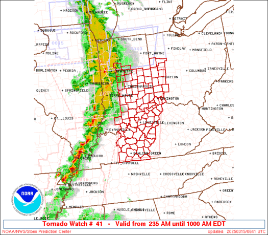
URGENT - IMMEDIATE BROADCAST REQUESTED
Tornado Watch Number 41
NWS Storm Prediction Center Norman OK
620 AM EDT Wed Mar 11 2026

The NWS Storm Prediction Center has issued a

* Tornado Watch for portions of
  East-Central and Southeast Illinois
  Central and Southern Indiana
  Far Northern Kentucky
  Western Ohio

* Effective this Wednesday morning from 620 AM until NOON EDT.

* Primary threats include...
  A couple tornadoes possible
  Scattered damaging wind gusts to 70 mph likely
  Isolated large hail events to 1.5 inches in diameter possible

SUMMARY...Thunderstorm coverage is expected to increase over the
next few both within and ahead of a convective line approaching from
the west. A warm, moist, and unstable airmass is in place across
much of the Ohio Valley, with very strong low-level shear in places
as well. These environmental conditions will support strong to
severe thunderstorms capable of all severe hazards, including
tornadoes.

The tornado watch area is approximately along and 75 statute miles
north and south of a line from 10 miles south of Salem IL to 25
miles east northeast of Dayton OH. For a complete depiction of the
watch see the associated watch outline update (WOUS64 KWNS WOU1).

PRECAUTIONARY/PREPAREDNESS ACTIONS...

REMEMBER...A Tornado Watch means conditions are favorable for
tornadoes and severe thunderstorms in and close to the watch
area. Persons in these areas should be on the lookout for
threatening weather conditions and listen for later statements
and possible warnings.

&&

AVIATION...Tornadoes and a few severe thunderstorms with hail
surface and aloft to 1.5 inches. Extreme turbulence and surface wind
gusts to 60 knots. A few cumulonimbi with maximum tops to 500. Mean
storm motion vector 24035.

...Mosier
Read morehttps://www.spc.noaa.gov/products/watch/ww0041.html
|
|


CMS The Best Conveyancing solicitors conveyancing quotes throughout the UK
For any webhosting enquiries please email webmaster@aus-city.com
|
|
Entire Thread
|
 SPC Tornado Watch 41
|
Webmaster
|
Wed 11 Mar 2026 10:22:AM
|
|
Forums60
Topics782,405
Posts817,165
Members2,960
| |
Most Online22,463
May 9th, 2026
|
|
|


 - Click image for larger picture.")


