|
|
|
0 members (),
1,983
guests, and
26
robots. |
|
Key:
Admin,
Global Mod,
Mod
|
|
S |
M |
T |
W |
T |
F |
S |
|
|
|
|
1
|
2
|
3
|
4
|
|
5
|
6
|
7
|
8
|
9
|
10
|
11
|
|
12
|
13
|
14
|
15
|
16
|
17
|
18
|
|
19
|
20
|
21
|
22
|
23
|
24
|
25
|
|
26
|
27
|
28
|
29
|
30
|
31
|
|
|
There are no members with birthdays on this day. |
|
|
|
|
|
|
|
|
|
|
|
|
|
|
|
|
|
|
|
|
|
|
by Webmaster - Tue 14 Jul 2026 10:01:PM
|

Volcano earthquake report for Friday, 10 Jul 2026
• Moderate mag. 4.2 earthquake - 133 km northwest of Ternate, Kota Ternate, N...
• World Earthquake Report for Friday, 10 July 2026
• Moderate mag. 4.6 earthquake - 17 km southwest of Comalapa, Estado de Chiap...
• Moderate mag. 4.1 earthquake - Olyutorskiy Rayon, 47 km northwest of Tilich...
• Moderate mag. 4.0 earthquake - Hawke's Bay, New Zealand, on Saturday, Jul 1...
|

#803359
Wed 25 Mar 2026 12:50:PM
|
Joined: Feb 2001
Posts: 678,976
Launch Director
|
OP

Launch Director
Joined: Feb 2001
Posts: 678,976 |
Volcano earthquake report for Wednesday, 25 Mar 2026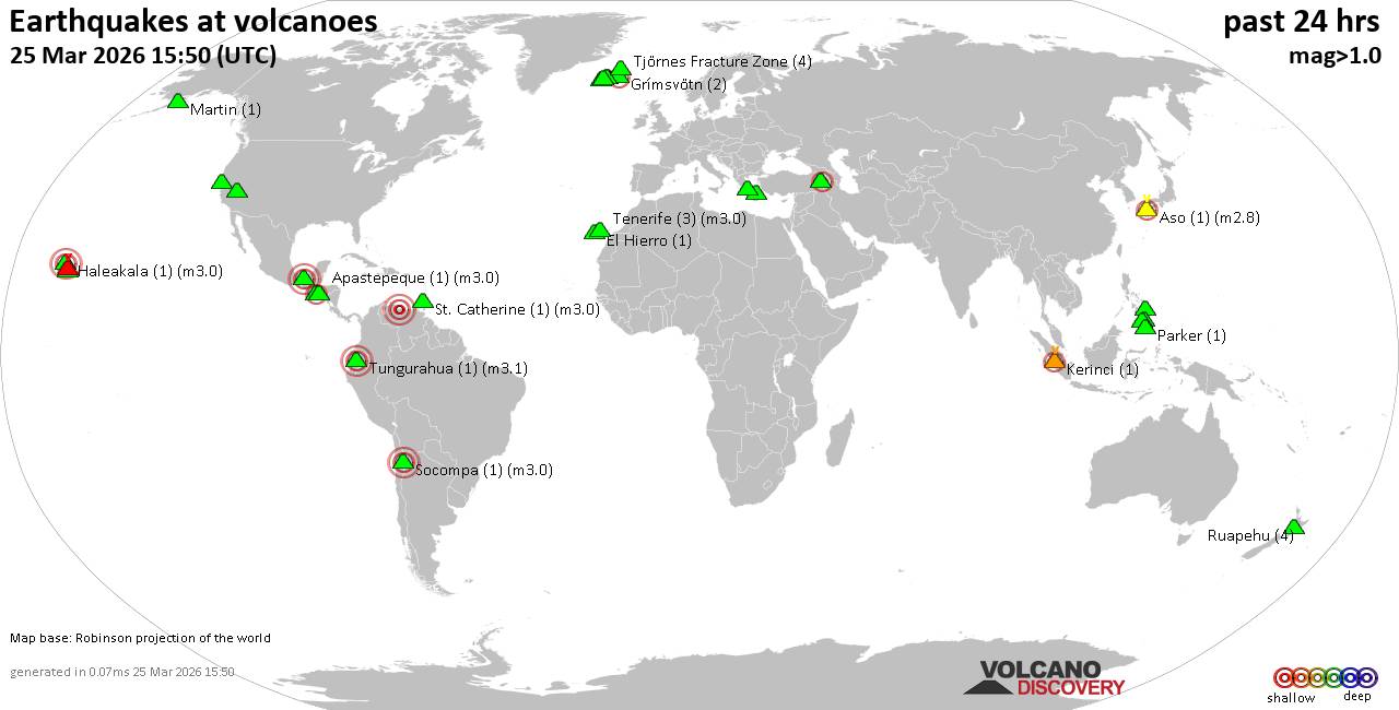 World map showing volcanoes with shallow (less than 50 km) earthquakes within 20 km radius during the past 24 hours on 25 Mar 2026 Number in brackets indicate nr of quakes. Quakes detected near: Apaneca Range (4 quakes between mag 1.5-2.2), Apastepeque (1 quake mag 3.0), Aso (1 quake mag 2.8), Clear Lake (22 quakes between mag 0.2-1.2), El Chichón (1 quake mag 2.0), El Hierro (1 quake mag 1.7)
Eldey (12 quakes between mag 0.6-1.9), Grímsnes (2 quakes between mag 0.9-2.0), Grímsvötn (1 quake mag 2.0), Haleakala (1 quake mag 3.0), Hrómundartindur (7 quakes between mag 0.0-1.0), Kalatungan (1 quake mag 1.8), Kerinci (1 quake mag 2.5), Kolumbo (1 quake mag 1.8), Krísuvík (7 quakes between mag 0.0-1.1), Makaturing (1 quake mag 1.7), Martin (1 quake mag 1.0), Maunaloa (1 quake mag 1.7), Methana (1 quake mag 1.8), Parker (1 quake mag 1.8), Ruapehu (4 quakes between mag 0.7-1.0), St. Catherine (1 quake mag 3.0), Svartsengi (1 quake mag 2.1), Tendürek Dağ (2 quakes between mag 1.0-2.1), Tenerife (4 quakes between mag 0.7-3.0), Tjörnes Fracture Zone (4 quakes between mag 0.0-1.0), Tungurahua (1 quake mag 3.1), Washiba-Kumonotaira (1 quake mag 3.4) (updated 12h50)
Note: Earthquakes within 20 km from and at depths less than 50 km under active volcanoes are reported. The list is not complete because many volcanoes are not monitored and/or seismic data in high resolution is not available publicly.
Volcanoes with recent earthquakes above magnitude 2 or more than 10 quakes are listed below:
Apaneca Range volcano (El Salvador): 4 earthquakes up to magnitude 2.24 earthquakes occurred near (under) the volcano during 13 minutes, the last being recorded quake 17 hours ago. Hypocenter depths ranged between 7.00 and 5.00 km. Earthquake details: 2.2 quake 19 km north of Sonsonate, Departamento de Sonsonate, El Salvador, Mar 24, 2026 01:57 pm (GMT -6) (6 km E) 2.1 quake 19 km north of Sonsonate, Departamento de Sonsonate, El Salvador, 2026-03-24 13:53:53 (6 km E) 1.8 quake 17 km north of Sonsonate, Departamento de Sonsonate, El Salvador, 2026-03-24 13:44:32 (6 km ESE) 1.5 quake 17 km north of Sonsonate, Departamento de Sonsonate, El Salvador, 2026-03-24 13:52:07 (6 km ESE) All earthquakes at Apaneca RangeApastepeque volcano (El Salvador): magnitude 3.0 earthquakeA magnitude 3.0 earthquake occurred at the volcano 5 hours ago. The quake, which might be volcanic in origin, was located at a depth of 10.00 km depth at 6 km distance SSE from the volcano. Earthquake details: Reported seismic-like event (likely no quake): 21 km east of Cojutepeque, Departamento de Cuscatlan, El Salvador, Mar 25, 2026 02:16 am (GMT -6) (6 km SSE) All earthquakes at ApastepequeAso volcano (Kyushu): magnitude 2.8 earthquakeA magnitude 2.8 earthquake occurred at the volcano 14 hours ago. The quake, which might be volcanic in origin, was located at a depth of 10.90 km depth at 14 km distance NNW from the volcano. Earthquake details: 2.8 quake 7.6 km northwest of Aso, Kumamoto, Japan, Mar 25, 2026 07:39 am (GMT +9) (14 km NNW) All earthquakes at AsoClear Lake volcano (California): 22 earthquakes up to magnitude 1.2Possible earthquake swarm: 22 earthquakes occurred near (under) the volcano during 23 hours, the last being recorded quake 33 minutes ago. Hypocenter depths ranged between 7.85 and 0.82 km. Earthquake details: (only 5 largest) 1.2 quake 25 mi north of Santa Rosa, Sonoma County, California, United States, Mar 24, 2026 05:25 pm (Universal Time) (19 km S) 1.2 quake Lake County, 28 mi north of Santa Rosa, Sonoma County, California, United States, Mar 24, 2026 02:30 pm (Universal Time) (15 km S) 1.1 quake Lake County, 25 mi north of Santa Rosa, Sonoma County, California, United States, Mar 25, 2026 06:06 am (Universal Time) (19 km SSE) 1.0 quake 28 mi north of Santa Rosa, Sonoma County, California, United States, Mar 25, 2026 05:59 am (Universal Time) (16 km SSW) 1.0 quake Lake County, 27 mi north of Santa Rosa, Sonoma County, California, United States, Mar 25, 2026 05:10 am (Universal Time) (16 km S) All earthquakes at Clear LakeEldey volcano (Iceland): 12 earthquakes up to magnitude 1.9Possible earthquake swarm: 12 earthquakes occurred near (under) the volcano during 15 hours, the last being recorded quake 9 hours ago. Hypocenter depths ranged between 18.00 and 0.00 km. Earthquake details: (only 5 largest) 1.9 quake Iceland: 2.1 km NW of Eldeyjardrangur Mar 24, 2026 05:49 pm (Reykjavik time) (1 km NW) 1.9 quake 4.2 km WNW of Geirfugladrangur Mar 24, 2026 12:57 pm (Universal Time) (19 km WSW) 1.7 quake Iceland: 3.7 km W of Geirfugladrangur Mar 24, 2026 06:07 pm (Reykjavik time) (19 km WSW) 1.6 quake Iceland: 2.9 km SW of Geirfugladrangur Mar 24, 2026 08:26 pm (Reykjavik time) (18 km WSW) 1.6 quake 4.7 km SSW of Geirfugladrangur Mar 24, 2026 05:45 pm (Universal Time) (19 km WSW) All earthquakes at EldeyEldey is located at the beginning of the Reykjanes Ridge off the SW tip of Iceland. Its highest elevation is the top of Eldey Island, but most of the volcanic edifice is submerged. Several eruptions occurred in historic times, last in 1926. Haleakala volcano (Hawaiian Islands): magnitude 3.0 earthquakeA magnitude 3.0 earthquake occurred at the volcano 9 hours ago. The quake, which might be volcanic in origin, was located at a depth of 10.00 km depth at 18 km distance W from the volcano. Earthquake details: Reported seismic-like event (likely no quake): 14 mi south of Kahului, Maui County, Hawaii, United States, Mar 24, 2026 05:22 pm (GMT -10) (18 km W) All earthquakes at HaleakalaKerinci volcano (Sumatra): magnitude 2.5 earthquakeA magnitude 2.5 earthquake occurred at the volcano 20 hours ago. The quake, which might be volcanic in origin, was located at a depth of 10.00 km depth at 10 km distance WNW from the volcano. Earthquake details: 2.5 quake Kabupaten Solok Selatan, Provinsi Sumatera Barat, 49 km northwest of Sungai Penuh, Indonesia, Mar 24, 2026 11:26 pm (GMT +7) (10 km WNW) All earthquakes at KerinciSt. Catherine volcano (Caribbean): magnitude 3.0 earthquakeA magnitude 3.0 earthquake occurred at the volcano 12 hours ago. The quake, which might be volcanic in origin, was located at a depth of 10.00 km depth at 16 km distance WSW from the volcano. Earthquake details: Unconfirmed earthquake or seismic-like event: 12 km northeast of Valencia, Carabobo, Venezuela, Mar 24, 2026 08:54 pm (GMT -4) (16 km WSW) All earthquakes at St. CatherineSvartsengi volcano (Reykjanes Peninsula, Iceland): magnitude 2.1 earthquakeA magnitude 2.1 earthquake occurred at the volcano 22 hours ago. The quake, which might be volcanic in origin, was located at a depth of 18.60 km depth at 15 km distance SSW from the volcano. Earthquake details: 2.1 quake Iceland: 7.6 km SE of Reykjanestá Mar 24, 2026 02:49 pm (Reykjavik time) (15 km SSW) All earthquakes at SvartsengiTendürek Dağ volcano (Turkey): 2 earthquakes up to magnitude 2.12 earthquakes occurred near (under) the volcano during 8 hours, the last being recorded quake 5 hours ago. Hypocenter depths ranged between 7.10 and 7.00 km. Earthquake details: 2.1 quake 14 km south of Dogubayazit, Agri, Turkey, Mar 25, 2026 08:00 am (Universal Time) (18 km ENE) 1.0 quake Van, 33 km southwest of Dogubayazit, Agri, Turkey, Mar 25, 2026 12:16 am (Universal Time) (5 km SW) All earthquakes at Tendürek DağTenerife volcano (Canary Islands): 4 earthquakes up to magnitude 3.04 earthquakes occurred near (under) the volcano during 19 hours, the last being recorded quake 3 hours ago. Hypocenter depths ranged between 15.00 and 6.00 km. Earthquake details: Reported seismic-like event (likely no quake): 28 km west of Santa Cruz de Tenerife, Spain, Mar 25, 2026 09:25 am (GMT +0) (16 km NE) 1.4 quake 15 km north of Arona, Santa Cruz de Tenerife, Canary Islands, Spain, Mar 25, 2026 06:06 am (Universal Time) (7 km SW) 1.3 quake 16 km north of Arona, Santa Cruz de Tenerife, Canary Islands, Spain, Mar 24, 2026 05:29 pm (Universal Time) (6 km WSW) 0.7 quake 17 km northeast of Arona, Santa Cruz de Tenerife, Canary Islands, Spain, Mar 24, 2026 02:50 pm (Universal Time) (7 km SE) All earthquakes at TenerifeTungurahua volcano (Ecuador): magnitude 3.1 earthquakeA magnitude 3.1 earthquake occurred at the volcano 19 hours ago. The quake, which might be volcanic in origin, was located at a depth of 10.00 km depth at 9 km distance N from the volcano. Earthquake details: 3.1 quake 18 km east of Ambato, Tungurahua, Ecuador, Mar 24, 2026 12:46 pm (GMT -5) (9 km N) All earthquakes at TungurahuaUnnamed 52.92°N/158.52°E volcano (Southern Kamchatka): magnitude 3.0 earthquakeA magnitude 3.0 earthquake occurred at the volcano 24 hours ago. The quake, which might be volcanic in origin, was located at a depth of 10.00 km depth at 15 km distance NNE from the volcano. Earthquake details: Reported seismic-like event (likely no quake): 3.5 km south of Petropavlovsk-Kamchatskiy, Kamchatka, Russia, Mar 25, 2026 01:05 am (GMT +12) (15 km NNE) All earthquakes at Unnamed 52.92°N/158.52°EWashiba-Kumonotaira volcano (Honshu): magnitude 3.4 earthquakeA magnitude 3.4 earthquake occurred at the volcano 24 hours ago. The quake, which might be volcanic in origin, was located at a depth of 0 km depth at 1 km distance SSE from the volcano. Earthquake details: 3.4 quake 48 km southeast of Toyama, Toyama, Japan, Mar 24, 2026 10:11 pm (GMT +9) (1 km SSE) All earthquakes at Washiba-Kumonotairahttps://www.volcanodiscovery.com/earthquakes-volcanoes/news/298494/Volcano-earthquake-report-for-Wednesday-25-Mar-2026.html
|
|


CMS The Best Conveyancing solicitors conveyancing quotes throughout the UK
For any webhosting enquiries please email webmaster@aus-city.com
|
|
Entire Thread
|
 Volcano earthquake report for Wednesday, 25 Mar 2026
|
Webmaster
|
Wed 25 Mar 2026 12:50:PM
|
|
Forums60
Topics788,790
Posts823,565
Members2,960
| |
Most Online102,106
Jul 10th, 2026
|
|
|
|
|
Copyright 1996 - 2026 by David Cottle. Designed by David Bate Jr. All Rights Reserved.
By using this forum, the user agrees not to transfer any data or technical information received under this agreement to any other entity without the express approval of the AUS-CITY Forum Admins and/or authors of individual posts (Forum Admins and DoD/USSPACECOM for the analysis of satellite tracking data).
Two-line elements (TLE) and all other satellite data presented and distributed via this forum and AUS-CITY mailing lists are distributed with permission from DoD/USSTRATCOM.

|

|


 - Click image for larger picture.")


