|
|
|
0 members (),
1,491
guests, and
58
robots. |
|
Key:
Admin,
Global Mod,
Mod
|
|
S |
M |
T |
W |
T |
F |
S |
|
|
|
|
1
|
2
|
3
|
4
|
|
5
|
6
|
7
|
8
|
9
|
10
|
11
|
|
12
|
13
|
14
|
15
|
16
|
17
|
18
|
|
19
|
20
|
21
|
22
|
23
|
24
|
25
|
|
26
|
27
|
28
|
29
|
30
|
31
|
|
|
There are no members with birthdays on this day. |

Volcano earthquake report for Friday, 10 Jul 2026
• Moderate mag. 4.2 earthquake - 133 km northwest of Ternate, Kota Ternate, N...
• World Earthquake Report for Friday, 10 July 2026
• Moderate mag. 4.6 earthquake - 17 km southwest of Comalapa, Estado de Chiap...
• Moderate mag. 4.1 earthquake - Olyutorskiy Rayon, 47 km northwest of Tilich...
• Moderate mag. 4.0 earthquake - Hawke's Bay, New Zealand, on Saturday, Jul 1...
|

#806189
Sun 19 Apr 2026 01:50:AM
|
Joined: Feb 2001
Posts: 678,976
Launch Director
|
OP

Launch Director
Joined: Feb 2001
Posts: 678,976 |
Volcano earthquake report for Sunday, 19 Apr 2026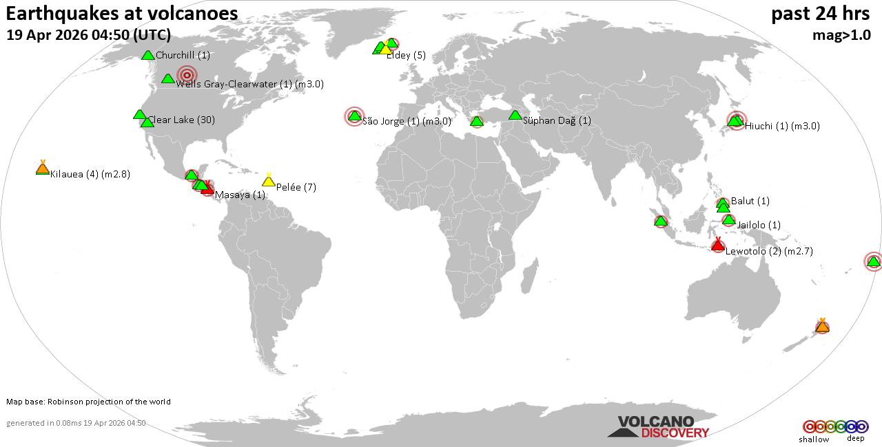 World map showing volcanoes with shallow (less than 50 km) earthquakes within 20 km radius during the past 24 hours on 19 Apr 2026 Number in brackets indicate nr of quakes. Quakes detected near: Apaneca Range (2 quakes between mag 2.1-2.2), Apo (1 quake mag 2.0), Balut (1 quake mag 2.3), Churchill (1 quake mag 1.2), Clear Lake (31 quakes between mag 0.2-1.7), Coso (3 quakes between mag 0.8-1.2)
El Chichón (3 quakes between mag 2.1-2.2), Eldey (5 quakes between mag 0.5-1.9), Grímsnes (2 quakes between mag 0.0-1.3), Imbabura (1 quake mag 3.0), Jailolo (1 quake mag 2.5), Katla (3 quakes between mag 0.0-2.1), Kilauea (5 quakes between mag 1.8-2.8), Kolumbo (1 quake mag 2.3), Lewotolo (1 quake mag 2.7), Ljósufjöll (2 quakes between mag 0.5-1.7), Masaya (1 quake mag 2.1), Midagahara (1 quake mag 3.0), Pelée (9 quakes between mag 0.2-1.1), Sorikmarapi (1 quake mag 2.3), São Jorge (1 quake mag 3.0), Süphan Dağ (1 quake mag 1.4), Tenerife (1 quake mag 1.5), Tjörnes Fracture Zone (62 quakes between mag 0.0-2.2), Upolu (1 quake mag 3.0), Usulután (1 quake mag 1.9), Wells Gray-Clearwater (1 quake mag 3.0), Whale Island (1 quake mag 2.2) (updated 01h50)
Note: Earthquakes within 20 km from and at depths less than 50 km under active volcanoes are reported. The list is not complete because many volcanoes are not monitored and/or seismic data in high resolution is not available publicly.
Volcanoes with recent earthquakes above magnitude 2 or more than 10 quakes are listed below:
Apaneca Range volcano (El Salvador): 2 earthquakes up to magnitude 2.22 earthquakes occurred near (under) the volcano during 2 minutes, the last being recorded quake 19 hours ago. Hypocenter depths ranged between 7.00 and 7.00 km. Earthquake details: 2.2 quake 5 km southeast of Ahuachapan, Departamento de Ahuachapan, El Salvador, Apr 18, 2026 12:58 am (GMT -6) (3 km WNW) 2.1 quake 6.5 km southeast of Ahuachapan, Departamento de Ahuachapan, El Salvador, Apr 18, 2026 12:56 am (GMT -6) (1 km N) All earthquakes at Apaneca RangeBalut volcano (Mindanao): magnitude 2.3 earthquakeA magnitude 2.3 earthquake occurred at the volcano 6 hours ago. The quake, which might be volcanic in origin, was located at a depth of 12.00 km depth at 16 km distance WNW from the volcano. Earthquake details: 2.3 quake Celebes Sea, 26 km west of Sarangani Island, Philippines, Apr 19, 2026 03:37 am (GMT +8) (16 km WNW) All earthquakes at BalutClear Lake volcano (California): 31 earthquakes up to magnitude 1.7Possible earthquake swarm: 31 earthquakes occurred near (under) the volcano during 22 hours, the last being recorded quake 1 hour 38 minutes ago. Hypocenter depths ranged between 13.46 and 0.99 km. Earthquake details: (only 5 largest) 1.7 quake Sonoma County, 14 mi southwest of Clearlake, Lake County, California, United States, Apr 18, 2026 12:58 am (GMT -7) (19 km S) 1.3 quake 27 mi north of Santa Rosa, Sonoma County, California, United States, Apr 17, 2026 07:11 pm (GMT -7) (17 km SSW) 1.3 quake Lake County, 27 mi north of Santa Rosa, Sonoma County, California, United States, Apr 18, 2026 01:14 pm (GMT -7) (16 km S) 1.2 quake 27 mi north of Santa Rosa, Sonoma County, California, United States, Apr 18, 2026 12:15 am (GMT -7) (17 km S) 1.2 quake 27 mi north of Santa Rosa, Sonoma County, California, United States, Apr 18, 2026 06:14 am (GMT -7) (17 km S) All earthquakes at Clear LakeEl Chichón volcano (Southern Mexico): 3 earthquakes up to magnitude 2.23 earthquakes occurred near (under) the volcano during 7 hours, the last being recorded quake 15 hours ago. Hypocenter depths ranged between 3.00 and 3.00 km. Earthquake details: 2.2 quake Estado de Chiapas, 36 km southwest of Teapa, Estado de Tabasco, Mexico, Apr 17, 2026 09:05 pm (GMT -6) (2 km ESE) 2.2 quake Estado de Chiapas, 36 km southwest of Teapa, Estado de Tabasco, Mexico, Apr 18, 2026 01:15 am (GMT -6) (2 km ESE) 2.1 quake Estado de Chiapas, 37 km southwest of Teapa, Estado de Tabasco, Mexico, Apr 18, 2026 04:22 am (GMT -6) (0 km N) All earthquakes at El ChichónImbabura volcano (Ecuador): magnitude 3.0 earthquakeA magnitude 3.0 earthquake occurred at the volcano 22 hours ago. The quake, which might be volcanic in origin, was located at a depth of 10.00 km depth at 13 km distance NNE from the volcano. Earthquake details: Reported seismic-like event (likely no quake): 1.5 km northwest of Ibarra, Provincia de Imbabura, Ecuador, Apr 17, 2026 11:14 pm (GMT -5) (13 km NNE) All earthquakes at ImbaburaJailolo volcano (Halmahera): magnitude 2.5 earthquakeA magnitude 2.5 earthquake occurred at the volcano 1 hour 0 minutes ago. The quake, which might be volcanic in origin, was located at a depth of 6.00 km depth at 6 km distance SW from the volcano. Earthquake details: 2.5 quake Maluku Sea, 28 km north of Ternate, Kota Ternate, North Maluku, Indonesia, Apr 19, 2026 09:49 am (GMT +9) (6 km SW) All earthquakes at JailoloKatla volcano (Iceland): 3 earthquakes up to magnitude 2.13 earthquakes occurred near (under) the volcano during 5 hours, the last being recorded quake 5 hours ago. Hypocenter depths ranged between 7.40 and 5.30 km. Earthquake details: 2.1 quake Iceland: 6.9 km NNE of Goðabunga Apr 18, 2026 03:32 pm (Reykjavik time) (10 km NW) 0.0 quake Iceland: 2.1 km ENE of Goðabunga Apr 18, 2026 08:35 pm (Reykjavik time) (8 km WNW) 0.0 quake Iceland: 6.9 km NNE of Goðabunga Apr 18, 2026 03:32 pm (Reykjavik time) (10 km NW) All earthquakes at KatlaKilauea volcano (Hawai'i (Big Island)): 5 earthquakes up to magnitude 2.85 earthquakes occurred near (under) the volcano during 23 hours, the last being recorded quake 28 minutes ago. Hypocenter depths ranged between 32.02 and 0.25 km. Earthquake details: 2.8 quake 31 mi south of Hilo, Hawaii County, Hawaii, United States, Apr 18, 2026 02:18 pm (GMT -10) (13 km SSE) 2.0 quake 36 mi southwest of Hilo, Hawaii County, Hawaii, United States, Apr 17, 2026 04:47 pm (GMT -10) (16 km SSW) 1.9 quake 26 mi southwest of Hilo, Hawaii County, Hawaii, United States, Apr 17, 2026 09:20 pm (GMT -10) (0 km E) 1.9 quake 37 mi southwest of Hilo, Hawaii County, Hawaii, United States, Apr 17, 2026 08:53 pm (GMT -10) (19 km SSW) 1.8 quake 36 mi southwest of Hilo, Hawaii County, Hawaii, United States, Apr 18, 2026 03:22 pm (GMT -10) (16 km SSW) All earthquakes at KilaueaKolumbo volcano (Greece): magnitude 2.3 earthquakeA magnitude 2.3 earthquake occurred at the volcano 20 hours ago. The quake, which might be volcanic in origin, was located at a depth of 26.76 km depth at 18 km distance NE from the volcano. Earthquake details: 2.3 quake Aegean Sea, 29 km northeast of Santorini Island, Greece, Apr 18, 2026 08:31 am (GMT +3) (18 km NE) All earthquakes at KolumboLewotolo volcano (Lesser Sunda Islands): magnitude 2.7 earthquakeA magnitude 2.7 earthquake occurred at the volcano 9 hours ago. The quake, which might be volcanic in origin, was located at a depth of 6.00 km depth at 6 km distance NNW from the volcano. Earthquake details: 2.7 quake 18 km north of Lewoleba, Kabupaten Lembata, East Nusa Tenggara, Indonesia, Apr 19, 2026 01:13 am (GMT +8) (6 km NNW) All earthquakes at LewotoloMasaya volcano (Nicaragua): magnitude 2.1 earthquakeA magnitude 2.1 earthquake occurred at the volcano 7 hours ago. The quake, which might be volcanic in origin, was located at a depth of 4.00 km depth at 3 km distance NNW from the volcano. Earthquake details: 2.1 quake 16 km southeast of Managua, Departamento de Managua, Nicaragua, Apr 18, 2026 12:31 pm (GMT -6) (3 km NNW) All earthquakes at MasayaMidagahara volcano (Honshu): magnitude 3.0 earthquakeA magnitude 3.0 earthquake occurred at the volcano 19 hours ago. The quake, which might be volcanic in origin, was located at a depth of 10.00 km depth at 0 km distance WNW from the volcano. Earthquake details: Reported quake or seismic-like event: 20 km west of Toyama, Toyama, Japan, Apr 18, 2026 04:12 pm (GMT +9) (0 km WNW) All earthquakes at MidagaharaSorikmarapi volcano (Sumatra): magnitude 2.3 earthquakeA magnitude 2.3 earthquake occurred at the volcano 21 hours ago. The quake, which might be volcanic in origin, was located at a depth of 5.00 km depth at 19 km distance ESE from the volcano. Earthquake details: 2.3 quake Kabupaten Mandailing Natal, 97 km southeast of Padangsidempuan, Indonesia, Apr 18, 2026 12:08 pm (GMT +7) (19 km ESE) All earthquakes at SorikmarapiSão Jorge volcano (Azores): magnitude 3.0 earthquakeA magnitude 3.0 earthquake occurred at the volcano 10 hours ago. The quake, which might be volcanic in origin, was located at a depth of 10.00 km depth at 3 km distance WSW from the volcano. Earthquake details: Reported seismic-like event (likely no quake): 30 km north of Lajes, Azores, Portugal, Apr 18, 2026 04:02 pm (GMT +0) (3 km WSW) All earthquakes at São JorgeTjörnes Fracture Zone volcano (Iceland): 62 earthquakes up to magnitude 2.2Possible earthquake swarm: 62 earthquakes occurred near (under) the volcano during 23 hours, the last being recorded quake 31 minutes ago. Hypocenter depths ranged between 12.70 and 0.00 km. Earthquake details: (only 5 largest) 2.2 quake Iceland: 11.2 km W of Kópasker Apr 18, 2026 07:13 pm (Reykjavik time) (18 km E) 1.6 quake 10.5 km W of Kópasker Apr 18, 2026 01:03 pm (Universal Time) (18 km E) 1.4 quake 10.8 km W of Kópasker Apr 18, 2026 06:36 am (Universal Time) (18 km E) 1.3 quake Iceland: 11.1 km W of Kópasker Apr 18, 2026 10:23 am (Reykjavik time) (18 km E) 1.3 quake 11.9 km W of Kópasker Apr 18, 2026 01:12 pm (Universal Time) (17 km E) All earthquakes at Tjörnes Fracture ZoneUpolu volcano (Samoan and Wallis Islands): magnitude 3.0 earthquakeA magnitude 3.0 earthquake occurred at the volcano 14 hours ago. The quake, which might be volcanic in origin, was located at a depth of 10.00 km depth at 14 km distance NW from the volcano. Earthquake details: Reported seismic-like event (likely no quake): 5 km west of Apia, Tuamasaga, Samoa, Apr 19, 2026 01:13 am (GMT +13) (14 km NW) All earthquakes at UpoluWells Gray-Clearwater volcano (Canada): magnitude 3.0 earthquakeA magnitude 3.0 earthquake occurred at the volcano 4 hours ago. The quake, which might be volcanic in origin, was located at a depth of 10.00 km depth at 5 km distance ENE from the volcano. Earthquake details: Unconfirmed earthquake or seismic-like event: Spring Lake, 33 km northeast of St. Albert, St. Albert, Alberta, Canada, Apr 18, 2026 04:00 pm (GMT -6) (5 km ENE) All earthquakes at Wells Gray-ClearwaterWhale Island volcano (New Zealand): magnitude 2.2 earthquakeA magnitude 2.2 earthquake occurred at the volcano 10 hours ago. The quake, which might be volcanic in origin, was located at a depth of 5.00 km depth at 18 km distance N from the volcano. Earthquake details: 2.2 quake South Pacific Ocean, 74 km east of Tauranga, Bay of Plenty, New Zealand, Apr 19, 2026 03:57 am (GMT +12) (18 km N) All earthquakes at Whale Islandhttps://www.volcanodiscovery.com/earthquakes-volcanoes/news/300233/Volcano-earthquake-report-for-Sunday-19-Apr-2026.html
|
|


CMS The Best Conveyancing solicitors conveyancing quotes throughout the UK
For any webhosting enquiries please email webmaster@aus-city.com
|
|
Entire Thread
|
 Volcano earthquake report for Sunday, 19 Apr 2026
|
Webmaster
|
Sun 19 Apr 2026 01:50:AM
|
|
Forums60
Topics788,488
Posts823,263
Members2,960
| |
Most Online102,106
Jul 10th, 2026
|
|
|
|
|
Copyright 1996 - 2026 by David Cottle. Designed by David Bate Jr. All Rights Reserved.
By using this forum, the user agrees not to transfer any data or technical information received under this agreement to any other entity without the express approval of the AUS-CITY Forum Admins and/or authors of individual posts (Forum Admins and DoD/USSPACECOM for the analysis of satellite tracking data).
Two-line elements (TLE) and all other satellite data presented and distributed via this forum and AUS-CITY mailing lists are distributed with permission from DoD/USSTRATCOM.

|

|


 - Click image for larger picture.")


