|
|
|
0 members (),
1,493
guests, and
20
robots. |
|
Key:
Admin,
Global Mod,
Mod
|
|
S |
M |
T |
W |
T |
F |
S |
|
|
1
|
2
|
3
|
4
|
5
|
6
|
|
7
|
8
|
9
|
10
|
11
|
12
|
13
|
|
14
|
15
|
16
|
17
|
18
|
19
|
20
|
|
21
|
22
|
23
|
24
|
25
|
26
|
27
|
|
28
|
29
|
30
|
|
|
|
|
|
There are no members with birthdays on this day. |

World Earthquake Report for Monday, 22 June 2026
• Moderate mag. 4.9 earthquake - Fiji Islands Region on Monday, Jun 22, 2026,...
• Moderate mag. 4.1 earthquake - South Pacific Ocean, 491 km northeast of Tau...
• Volcano earthquake report for Monday, 22 Jun 2026
• Moderate mag. 4.6 earthquake - 42 km south of Tocopilla, Provincia de Tocop...
• Moderate mag. 4.9 earthquake - South Pacific Ocean, 277 km south of Nuku'al...
|

#809965
Tue 12 May 2026 01:50:PM
|
Joined: Feb 2001
Posts: 678,976
Launch Director
|
OP

Launch Director
Joined: Feb 2001
Posts: 678,976 |
Volcano earthquake report for Tuesday, 12 May 2026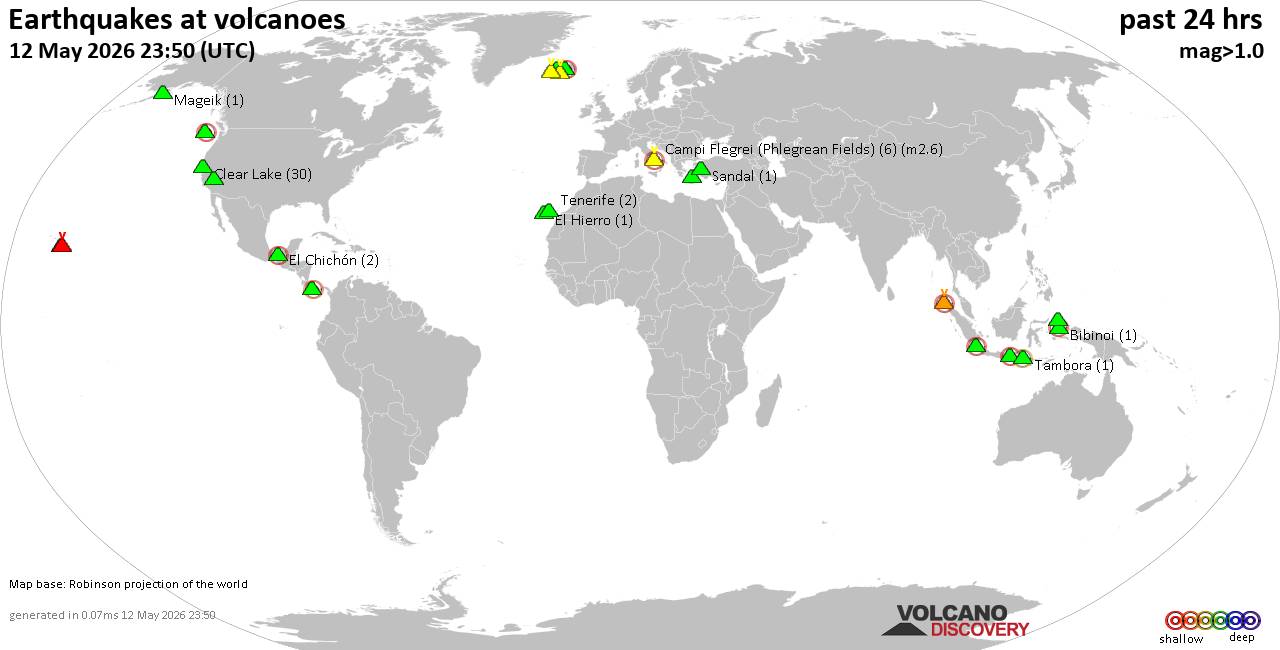 World map showing volcanoes with shallow (less than 50 km) earthquakes within 20 km radius during the past 24 hours on 12 May 2026 Number in brackets indicate nr of quakes. Quakes detected near: Bardarbunga (28 quakes between mag 0.0-2.1), Bibinoi (1 quake mag 2.3), Campi Flegrei (Phlegrean Fields) (2 quakes between mag 1.2-1.8), Cerro Singüil (1 quake mag 3.0), Churchill (1 quake mag 1.2), Clear Lake (25 quakes between mag 0.3-2.0)
El Chichón (1 quake mag 2.1), Eldey (6 quakes between mag 0.2-1.7), Endeavour Ridge (1 quake mag 2.8), Grímsvötn (7 quakes between mag 0.4-1.0), Katla (3 quakes between mag 0.1-1.0), Kilauea (2 quakes between mag 1.8-2.2), Kolumbo (2 quakes between mag 1.5-1.6), Ljósufjöll (2 quakes between mag 0.1-1.2), Maunaloa (5 quakes between mag 1.6-2.3), Prestahnukur (27 quakes between mag 0.3-2.9), Sandal (1 quake mag 1.0), Seulawah Agam (1 quake mag 2.4), Stepovak Bay 4 (2 quakes between mag 1.2-2.6), Tenerife (2 quakes between mag 1.0-1.3), Tjörnes Fracture Zone (5 quakes between mag 0.4-1.2) (updated 13h50)
Note: Earthquakes within 20 km from and at depths less than 50 km under active volcanoes are reported. The list is not complete because many volcanoes are not monitored and/or seismic data in high resolution is not available publicly.
Volcanoes with recent earthquakes above magnitude 2 or more than 10 quakes are listed below:
Bardarbunga volcano (Iceland): 28 earthquakes up to magnitude 2.1Possible earthquake swarm: 28 earthquakes occurred near (under) the volcano during 22 hours, the last being recorded quake 53 minutes ago. Hypocenter depths ranged between 15.50 and 0.00 km. Earthquake details: (only 5 largest) 2.1 quake Iceland: 8.2 km SE of Bárðarbunga May 11, 2026 03:23 pm (Reykjavik time) (8 km SE) 2.0 quake 5.5 km ENE of Bárðarbunga May 12, 2026 06:31 am (Universal Time) (6 km NE) 1.1 quake Iceland: 2.9 km ESE of Bárðarbunga May 12, 2026 03:34 am (Reykjavik time) (3 km E) 0.9 quake 2.7 km SE of Bárðarbunga May 11, 2026 03:55 pm (Universal Time) (2 km ESE) 0.8 quake Iceland: 2.7 km N of Bárðarbunga May 12, 2026 03:34 am (Reykjavik time) (4 km N) All earthquakes at BardarbungaBibinoi volcano (Halmahera): magnitude 2.3 earthquakeA magnitude 2.3 earthquake occurred at the volcano 13 hours ago. The quake, which might be volcanic in origin, was located at a depth of 6.00 km depth at 11 km distance WNW from the volcano. Earthquake details: 2.3 quake 21 km southeast of Labuha, Kabupaten Halmahera Selatan, North Maluku, Indonesia, May 12, 2026 09:30 am (GMT +9) (11 km WNW) All earthquakes at BibinoiCerro Singüil volcano (El Salvador): magnitude 3.0 earthquakeA magnitude 3.0 earthquake occurred at the volcano 17 hours ago. The quake, which might be volcanic in origin, was located at a depth of 10.00 km depth at 12 km distance ESE from the volcano. Earthquake details: Reported seismic-like event (likely no quake): 0.7 km northwest of Santa Ana, Departamento de Santa Ana, El Salvador, May 11, 2026 03:11 pm (GMT -6) (12 km ESE) All earthquakes at Cerro SingüilClear Lake volcano (California): 25 earthquakes up to magnitude 2.0Possible earthquake swarm: 25 earthquakes occurred near (under) the volcano during 20 hours, the last being recorded quake 1 hour 1 minutes ago. Hypocenter depths ranged between 12.01 and 1.04 km. Earthquake details: (only 5 largest) 2.0 quake Sonoma County, 13 mi southwest of Clearlake, Lake County, California, United States, May 11, 2026 10:40 am (GMT -7) (16 km SSW) 1.5 quake Sonoma County, 13 mi southwest of Clearlake, Lake County, California, United States, May 11, 2026 10:03 pm (GMT -7) (17 km S) 1.3 quake Lake County, 28 mi north of Santa Rosa, Sonoma County, California, United States, May 11, 2026 06:26 pm (GMT -7) (15 km S) 1.3 quake 26 mi north of Santa Rosa, Sonoma County, California, United States, May 11, 2026 03:39 pm (GMT -7) (18 km S) 1.3 quake 27 mi north of Santa Rosa, Sonoma County, California, United States, May 11, 2026 08:09 pm (GMT -7) (17 km SSW) All earthquakes at Clear LakeEl Chichón volcano (Southern Mexico): magnitude 2.1 earthquakeA magnitude 2.1 earthquake occurred at the volcano 22 hours ago. The quake, which might be volcanic in origin, was located at a depth of 2.90 km depth at 1 km distance E from the volcano. Earthquake details: 2.1 quake Estado de Chiapas, 36 km southwest of Teapa, Estado de Tabasco, Mexico, May 11, 2026 09:31 am (GMT -6) (1 km E) All earthquakes at El ChichónEndeavour Ridge volcano (Northern Pacific Ocean): magnitude 2.8 earthquakeA magnitude 2.8 earthquake occurred at the volcano 2 hours ago. The quake, which might be volcanic in origin, was located at a depth of 10.00 km depth at 19 km distance E from the volcano. Earthquake details: 2.8 quake 254 km WSW of Tofino, Canada, May 12, 2026 02:34 am (GMT -9) (19 km E) All earthquakes at Endeavour RidgeKilauea volcano (Hawai'i (Big Island)): 2 earthquakes up to magnitude 2.22 earthquakes occurred near (under) the volcano during 8 hours, the last being recorded quake 1 hour 50 minutes ago. Hypocenter depths ranged between 7.47 and 0.72 km. Earthquake details: 2.2 quake 28 mi south of Hilo, Hawaii County, Hawaii, United States, May 11, 2026 06:14 pm (GMT -10) (12 km SE) 1.8 quake 26 mi southwest of Hilo, Hawaii County, Hawaii, United States, May 12, 2026 02:00 am (GMT -10) (1 km E) All earthquakes at KilaueaMaunaloa volcano (Hawai'i (Big Island)): 5 earthquakes up to magnitude 2.35 earthquakes occurred near (under) the volcano during 20 hours, the last being recorded quake 1 hour 2 minutes ago. Hypocenter depths ranged between 9.27 and 0.40 km. Earthquake details: 2.3 quake 36 mi southwest of Hilo, Hawaii County, Hawaii, United States, May 11, 2026 02:15 pm (GMT -10) (18 km SE) 2.2 quake 36 mi southwest of Hilo, Hawaii County, Hawaii, United States, May 11, 2026 02:31 pm (GMT -10) (18 km SE) 2.1 quake 30 mi southwest of Hilo, Hawaii County, Hawaii, United States, May 12, 2026 02:47 am (GMT -10) (16 km E) 1.7 quake 38 mi southwest of Hilo, Hawaii County, Hawaii, United States, May 11, 2026 07:13 am (GMT -10) (2 km SE) 1.6 quake 10.8 mi north of Pāhala, Hawaii County, Hawaii, United States, May 11, 2026 01:53 pm (GMT -10) (18 km SE) All earthquakes at MaunaloaPrestahnukur volcano (Iceland): 27 earthquakes up to magnitude 2.9Possible earthquake swarm: 27 earthquakes occurred near (under) the volcano during 20 hours, the last being recorded quake 4 hours ago. Hypocenter depths ranged between 19.30 and 2.70 km. Earthquake details: (only 5 largest) 2.9 quake West, 71 km northeast of Reykjavik, Capital Region, Iceland, May 11, 2026 02:24 pm (Universal Time) (12 km WSW) 1.8 quake Iceland: 16.2 km S of Húsafell May 12, 2026 01:53 am (Reykjavik time) (14 km WSW) 1.8 quake Iceland: 16.8 km SSE of Húsafell May 12, 2026 06:49 am (Reykjavik time) (8 km SW) 1.7 quake 14.6 km SSE of Húsafell May 11, 2026 09:32 pm (Universal Time) (11 km WSW) 1.7 quake 16.7 km SSE of Húsafell May 11, 2026 10:10 pm (Universal Time) (8 km SW) All earthquakes at PrestahnukurSeulawah Agam volcano (Sumatra): magnitude 2.4 earthquakeA magnitude 2.4 earthquake occurred at the volcano 24 minutes ago. The quake, which might be volcanic in origin, was located at a depth of 4.00 km depth at 6 km distance S from the volcano. Earthquake details: 2.4 quake Kabupaten Aceh Besar, 40 km southeast of Banda Aceh, Indonesia, May 12, 2026 08:26 pm (GMT +7) (6 km S) All earthquakes at Seulawah AgamStepovak Bay 4 volcano (Alaska Peninsula): 2 earthquakes up to magnitude 2.62 earthquakes occurred near (under) the volcano during 10 minutes, the last being recorded quake 23 hours ago. Hypocenter depths ranged between 5.54 and 5.00 km. Earthquake details: 2.6 quake 52 mi northeast of Sand Point, Aleutians East Borough, Alaska, United States, May 11, 2026 07:08 am (GMT -8) (6 km N) 1.2 quake Lake and Peninsula Borough, 48 mi northeast of Sand Point, Aleutians East Borough, Alaska, United States, May 11, 2026 06:58 am (GMT -8) (13 km ESE) All earthquakes at Stepovak Bay 4https://www.volcanodiscovery.com/earthquakes-volcanoes/news/302121/Volcano-earthquake-report-for-Tuesday-12-May-2026.html
|
|


CMS The Best Conveyancing solicitors conveyancing quotes throughout the UK
For any webhosting enquiries please email webmaster@aus-city.com
|
|
Entire Thread
|
 Volcano earthquake report for Tuesday, 12 May 2026
|
Webmaster
|
Tue 12 May 2026 01:50:PM
|
|
Forums60
Topics784,206
Posts818,971
Members2,960
| |
Most Online22,463
May 9th, 2026
|
|
|
|
|
Copyright 1996 - 2026 by David Cottle. Designed by David Bate Jr. All Rights Reserved.
By using this forum, the user agrees not to transfer any data or technical information received under this agreement to any other entity without the express approval of the AUS-CITY Forum Admins and/or authors of individual posts (Forum Admins and DoD/USSPACECOM for the analysis of satellite tracking data).
Two-line elements (TLE) and all other satellite data presented and distributed via this forum and AUS-CITY mailing lists are distributed with permission from DoD/USSTRATCOM.

|

|


 - Click image for larger picture.")


