|
|
|
2 members (Alisa, Webmaster),
1,222
guests, and
24
robots. |
|
Key:
Admin,
Global Mod,
Mod
|
|
S |
M |
T |
W |
T |
F |
S |
|
|
|
|
|
|
1
|
2
|
|
3
|
4
|
5
|
6
|
7
|
8
|
9
|
|
10
|
11
|
12
|
13
|
14
|
15
|
16
|
|
17
|
18
|
19
|
20
|
21
|
22
|
23
|
|
24
|
25
|
26
|
27
|
28
|
29
|
30
|
|
31
|
|
|
|
|
|
|
|
There are no members with birthdays on this day. |
|
|
Joined: Feb 2001
Posts: 381,904
Launch Director
|
OP

Launch Director
Joined: Feb 2001
Posts: 381,904 |
Volcano earthquake report for Sunday, 17 May 2026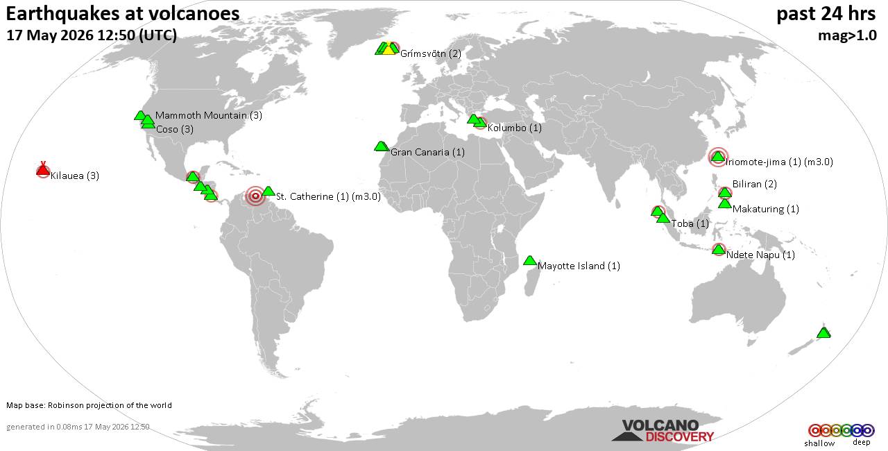 World map showing volcanoes with shallow (less than 50 km) earthquakes within 20 km radius during the past 24 hours on 17 May 2026 Number in brackets indicate nr of quakes. Quakes detected near: Agua (1 quake mag 2.9), Apaneca Range (2 quakes between mag 1.6-1.8), Bardarbunga (20 quakes between mag 0.0-1.4), Biliran (2 quakes between mag 1.9-2.0), Clear Lake (22 quakes between mag 0.3-1.4), Coso (2 quakes between mag 0.7-1.0)
Eldey (11 quakes between mag 0.4-1.6), Geureudong (1 quake mag 2.3), Grímsvötn (4 quakes between mag 0.0-1.9), Hofsjökull (3 quakes between mag 0.9-1.4), Hrómundartindur (6 quakes between mag 0.2-1.0), Katla (12 quakes between mag 0.0-1.6), Kilauea (3 quakes between mag 2.1-2.4), Kolumbo (1 quake mag 2.0), La Palma (1 quake mag 1.7), Las Pilas (1 quake mag 2.1), Ljósufjöll (8 quakes between mag 0.4-1.3), Makaturing (2 quakes between mag 1.8-2.8), Mammoth Mountain (3 quakes between mag 0.3-1.4), Maroa (1 quake mag 1.8), Mayotte Island (1 quake mag 1.2), Prestahnukur (13 quakes between mag 0.5-1.9), Santo Tomas (1 quake mag 1.3), Sousaki (1 quake mag 1.7), St. Catherine (1 quake mag 3.0), Stepovak Bay 4 (1 quake mag 2.5), Talakmau (1 quake mag 2.2), Tambora (1 quake mag 3.4), Taupo (1 quake mag 1.8), Tenerife (1 quake mag 1.0), Tenorio (1 quake mag 2.3) (updated 21h50)
Note: Earthquakes within 20 km from and at depths less than 50 km under active volcanoes are reported. The list is not complete because many volcanoes are not monitored and/or seismic data in high resolution is not available publicly.
Volcanoes with recent earthquakes above magnitude 2 or more than 10 quakes are listed below:
Agua volcano (Guatemala): magnitude 2.9 earthquakeA magnitude 2.9 earthquake occurred at the volcano 17 minutes ago. The quake, which might be volcanic in origin, was located at a depth of 10.00 km depth at 6 km distance ESE from the volcano. Earthquake details: 2.9 quake 4.1 km north of Palin, Departamento de Escuintla, Guatemala, May 17, 2026 03:33 pm (GMT -6) (6 km ESE) All earthquakes at AguaBardarbunga volcano (Iceland): 20 earthquakes up to magnitude 1.4Possible earthquake swarm: 20 earthquakes occurred near (under) the volcano during 19 hours, the last being recorded quake 4 hours ago. Hypocenter depths ranged between 11.40 and 0.00 km. Earthquake details: (only 5 largest) 1.4 quake 4.7 km ESE of Bárðarbunga May 17, 2026 04:57 pm (Universal Time) (4 km ESE) 0.6 quake Iceland: 4.3 km ENE of Bárðarbunga May 17, 2026 12:19 am (Reykjavik time) (5 km NE) 0.5 quake 6.7 km ESE of Bárðarbunga May 17, 2026 01:22 am (Universal Time) (6 km E) 0.5 quake Iceland: 5.6 km SW of Bárðarbunga May 16, 2026 10:04 pm (Reykjavik time) (5 km SW) 0.4 quake 6.1 km SW of Bárðarbunga May 17, 2026 02:18 am (Universal Time) (5 km SW) All earthquakes at BardarbungaClear Lake volcano (California): 22 earthquakes up to magnitude 1.4Possible earthquake swarm: 22 earthquakes occurred near (under) the volcano during 22 hours, the last being recorded quake 1 hour 38 minutes ago. Hypocenter depths ranged between 4.84 and 0.21 km. Earthquake details: (only 5 largest) 1.4 quake 25 mi north of Santa Rosa, Sonoma County, California, United States, May 17, 2026 12:02 am (GMT -7) (19 km S) 1.1 quake 27 mi north of Santa Rosa, Sonoma County, California, United States, May 16, 2026 08:54 pm (GMT -7) (18 km SSW) 1.1 quake 25 mi north of Santa Rosa, Sonoma County, California, United States, May 16, 2026 10:02 pm (GMT -7) (18 km S) 1.1 quake 26 mi north of Santa Rosa, Sonoma County, California, United States, May 17, 2026 12:28 pm (GMT -7) (19 km SSW) 1.1 quake 27 mi north of Santa Rosa, Sonoma County, California, United States, May 17, 2026 07:27 am (GMT -7) (17 km S) All earthquakes at Clear LakeEldey volcano (Iceland): 11 earthquakes up to magnitude 1.6Possible earthquake swarm: 11 earthquakes occurred near (under) the volcano during 18 hours, the last being recorded quake 1 hour 43 minutes ago. Hypocenter depths ranged between 10.90 and 6.80 km. Earthquake details: (only 5 largest) 1.6 quake 8.1 km N of Eldey May 17, 2026 07:43 pm (Universal Time) (9 km N) 1.2 quake Iceland: 8.8 km N of Eldey May 17, 2026 08:05 pm (Reykjavik time) (10 km N) 1.0 quake Iceland: 9.4 km NNE of Eldey May 17, 2026 08:06 pm (Reykjavik time) (11 km NNE) 1.0 quake Iceland: 7.5 km N of Eldey May 17, 2026 02:37 pm (Reykjavik time) (9 km NNE) 1.0 quake Iceland: 10.2 km NNE of Eldey May 17, 2026 02:33 am (Reykjavik time) (12 km NNE) All earthquakes at EldeyEldey is located at the beginning of the Reykjanes Ridge off the SW tip of Iceland. Its highest elevation is the top of Eldey Island, but most of the volcanic edifice is submerged. Several eruptions occurred in historic times, last in 1926. Geureudong volcano (Sumatra): magnitude 2.3 earthquakeA magnitude 2.3 earthquake occurred at the volcano 21 hours ago. The quake, which might be volcanic in origin, was located at a depth of 3.00 km depth at 1 km distance E from the volcano. Earthquake details: 2.3 quake Kabupaten Bener Meriah, 50 km south of Bireun, Indonesia, May 17, 2026 07:30 am (GMT +7) (1 km E) All earthquakes at GeureudongKatla volcano (Iceland): 12 earthquakes up to magnitude 1.6Possible earthquake swarm: 12 earthquakes occurred near (under) the volcano during 16 hours, the last being recorded quake 1 hour 25 minutes ago. Hypocenter depths ranged between 6.40 and 0.00 km. Earthquake details: (only 5 largest) 1.6 quake 4.3 km ENE of Goðabunga May 17, 2026 09:38 am (Universal Time) (6 km WNW) 1.2 quake Iceland: 4.0 km NNE of Hábunga May 17, 2026 06:28 pm (Reykjavik time) (2 km SSW) 1.2 quake Iceland: 4.1 km WNW of Hábunga May 17, 2026 06:15 pm (Reykjavik time) (8 km SW) 1.2 quake 6.5 km NNE of Hábunga May 17, 2026 02:39 pm (Universal Time) (1 km NNW) 1.1 quake 3.6 km NNW of Hábunga May 17, 2026 02:35 pm (Universal Time) (5 km SW) All earthquakes at KatlaKilauea volcano (Hawai'i (Big Island)): 3 earthquakes up to magnitude 2.43 earthquakes occurred near (under) the volcano during 17 hours, the last being recorded quake 45 minutes ago. Hypocenter depths ranged between 32.06 and 2.68 km. Earthquake details: 2.4 quake 33 mi southwest of Hilo, Hawaii County, Hawaii, United States, May 16, 2026 10:11 pm (GMT -10) (15 km WSW) 2.1 quake 29 mi south of Hilo, Hawaii County, Hawaii, United States, May 17, 2026 11:05 am (GMT -10) (12 km SE) 2.1 quake 7.5 mi northeast of Pāhala, Hawaii County, Hawaii, United States, May 16, 2026 06:25 pm (GMT -10) (18 km SW) All earthquakes at KilaueaLas Pilas volcano (Nicaragua): magnitude 2.1 earthquakeA magnitude 2.1 earthquake occurred at the volcano 23 hours ago. The quake, which might be volcanic in origin, was located at a depth of 7.00 km depth at 6 km distance ESE from the volcano. Earthquake details: 2.1 quake 26 km east of Leon, Departamento de Leon, Nicaragua, May 16, 2026 05:17 pm (GMT -6) (6 km ESE) All earthquakes at Las PilasMakaturing volcano (Mindanao): 2 earthquakes up to magnitude 2.82 earthquakes occurred near (under) the volcano during 3 hours, the last being recorded quake 8 hours ago. Hypocenter depths ranged between 24.00 and 5.00 km. Earthquake details: 2.8 quake Province of Lanao del Sur, 50 km north of Cotabato, Philippines, May 17, 2026 09:36 pm (GMT +8) (7 km E) 1.8 quake 31 km south of Marawi City, Philippines, May 17, 2026 07:06 pm (GMT +8) (14 km NW) All earthquakes at MakaturingPrestahnukur volcano (Iceland): 13 earthquakes up to magnitude 1.9Possible earthquake swarm: 13 earthquakes occurred near (under) the volcano during 18 hours, the last being recorded quake 3 hours ago. Hypocenter depths ranged between 18.60 and 0.00 km. Earthquake details: (only 5 largest) 1.9 quake Iceland: 15.9 km S of Húsafell May 17, 2026 08:07 am (Reykjavik time) (14 km WSW) 1.4 quake Iceland: 16.1 km SSE of Húsafell May 17, 2026 07:01 pm (Reykjavik time) (11 km WSW) 1.4 quake 18.0 km SE of Húsafell May 17, 2026 01:16 am (Universal Time) (1 km S) 1.2 quake Iceland: 15.4 km S of Húsafell May 17, 2026 04:38 pm (Reykjavik time) (13 km WSW) 1.1 quake 15.8 km SSE of Húsafell May 17, 2026 05:19 pm (Universal Time) (12 km WSW) All earthquakes at PrestahnukurSt. Catherine volcano (Caribbean): magnitude 3.0 earthquakeA magnitude 3.0 earthquake occurred at the volcano 20 hours ago. The quake, which might be volcanic in origin, was located at a depth of 10.00 km depth at 19 km distance WSW from the volcano. Earthquake details: Uncertain quake: M3.0, 2.1 km southwest of Caracas, Distrito Federal, Venezuela, May 16, 2026 10:18 pm (GMT -4) (19 km WSW) All earthquakes at St. CatherineStepovak Bay 4 volcano (Alaska Peninsula): magnitude 2.5 earthquakeA magnitude 2.5 earthquake occurred at the volcano 6 hours ago. The quake, which might be volcanic in origin, was located at a depth of 5.00 km depth at 17 km distance NNW from the volcano. Earthquake details: 2.5 quake 56 mi north of Sand Point, Aleutians East Borough, Alaska, United States, May 17, 2026 08:02 am (GMT -8) (17 km NNW) All earthquakes at Stepovak Bay 4Talakmau volcano (Sumatra): magnitude 2.2 earthquakeA magnitude 2.2 earthquake occurred at the volcano 6 hours ago. The quake, which might be volcanic in origin, was located at a depth of 7.00 km depth at 2 km distance ESE from the volcano. Earthquake details: 2.2 quake Kabupaten Pasaman, 59 km northwest of Bukittinggi, Indonesia, May 17, 2026 10:27 pm (GMT +7) (2 km ESE) All earthquakes at TalakmauTambora volcano (Sumbawa): magnitude 3.4 earthquakeA magnitude 3.4 earthquake occurred at the volcano 2 hours ago. The quake, which might be volcanic in origin, was located at a depth of 23.00 km depth at 15 km distance SSE from the volcano. Earthquake details: 3.4 quake 49 km west of Dompu, Kabupaten Dompu, West Nusa Tenggara, Indonesia, May 18, 2026 03:47 am (GMT +8) (15 km SSE) All earthquakes at TamboraTenorio volcano (Costa Rica): magnitude 2.3 earthquakeA magnitude 2.3 earthquake occurred at the volcano 23 hours ago. The quake, which might be volcanic in origin, was located at a depth of 13.00 km depth at 9 km distance SE from the volcano. Earthquake details: 2.3 quake Provincia de Alajuela, 24 km northeast of Canas, Costa Rica, May 16, 2026 04:43 pm (Costa_Rica time) (9 km SE) All earthquakes at Tenoriohttps://www.volcanodiscovery.com/earthquakes-volcanoes/news/302650/Volcano-earthquake-report-for-Sunday-17-May-2026.html
|
|


CMS The Best Conveyancing solicitors conveyancing quotes throughout the UK
For any webhosting enquiries please email webmaster@aus-city.com
|
|
Entire Thread
|

 Volcano earthquake report for Sunday, 17 May 2026
|
Webmaster
|
Yesterday at 09:50 PM
|
|
Forums60
Topics775,003
Posts809,792
Members2,960
| |
Most Online22,463
May 9th, 2026
|
|
|
|
|
Copyright 1996 - 2026 by David Cottle. Designed by David Bate Jr. All Rights Reserved.
By using this forum, the user agrees not to transfer any data or technical information received under this agreement to any other entity without the express approval of the AUS-CITY Forum Admins and/or authors of individual posts (Forum Admins and DoD/USSPACECOM for the analysis of satellite tracking data).
Two-line elements (TLE) and all other satellite data presented and distributed via this forum and AUS-CITY mailing lists are distributed with permission from DoD/USSTRATCOM.

|

|


 - Click image for larger picture.")


