|
|
|
1 members (Alisa),
1,642
guests, and
27
robots. |
|
Key:
Admin,
Global Mod,
Mod
|
|
S |
M |
T |
W |
T |
F |
S |
|
|
1
|
2
|
3
|
4
|
5
|
6
|
|
7
|
8
|
9
|
10
|
11
|
12
|
13
|
|
14
|
15
|
16
|
17
|
18
|
19
|
20
|
|
21
|
22
|
23
|
24
|
25
|
26
|
27
|
|
28
|
29
|
30
|
|
|
|
|
|
There are no members with birthdays on this day. |

Magnitude 5.3 earthquake strikes near Palu, Kota Palu, Sulawesi Tengah, Indonesia
• Strong mag. 5.2 earthquake - Kabupaten Sigi, 25 km southeast of Palu, Kota ...
• Strong mag. 5.2 earthquake - Kabupaten Sigi, 25 km southeast of Palu, Kota ...
• Volcano earthquake report for Tuesday, 16 Jun 2026
• Volcano earthquake report for Tuesday, 16 Jun 2026
|

#811964
Tue 19 May 2026 12:50:AM
|
Joined: Feb 2001
Posts: 678,976
Launch Director
|
OP

Launch Director
Joined: Feb 2001
Posts: 678,976 |
Volcano earthquake report for Tuesday, 19 May 2026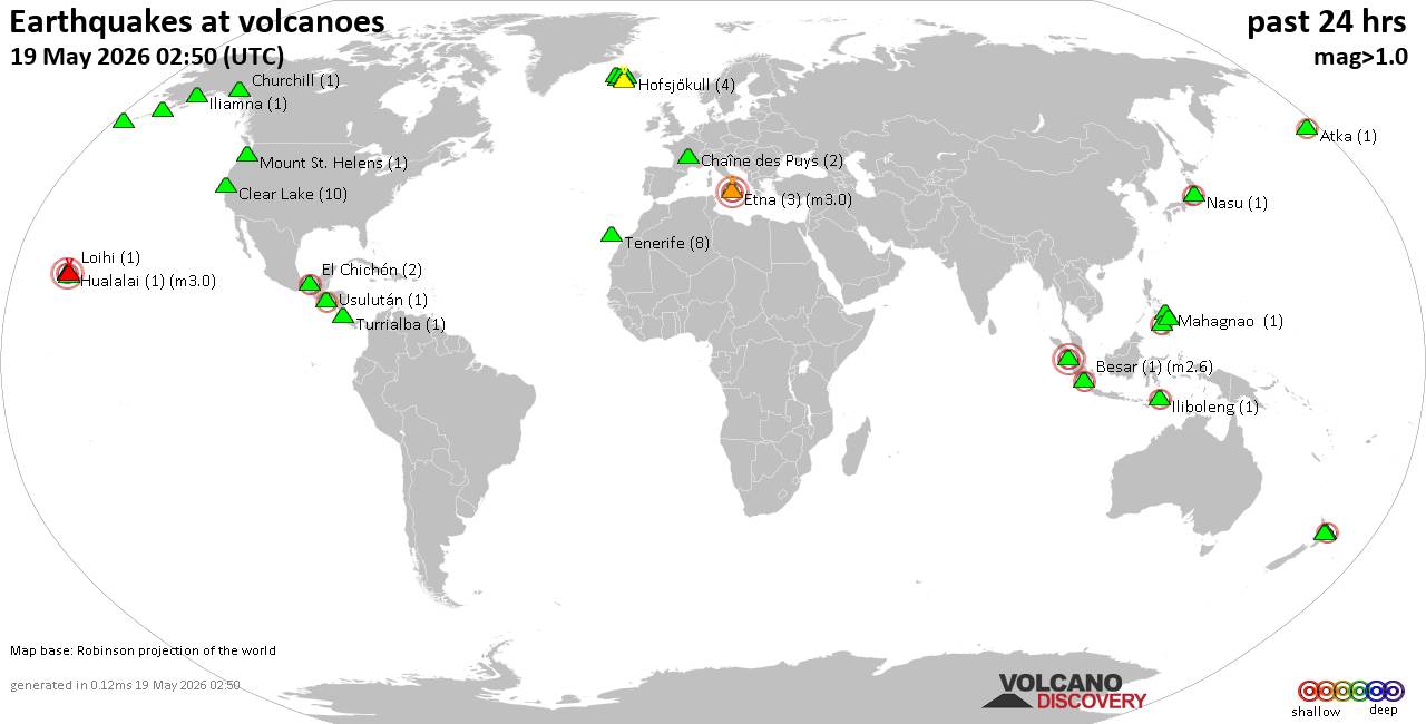 World map showing volcanoes with shallow (less than 50 km) earthquakes within 20 km radius during the past 24 hours on 19 May 2026 Number in brackets indicate nr of quakes. Quakes detected near: Bardarbunga (12 quakes between mag 0.0-1.0), Barva (1 quake mag 1.7), Black Peak (1 quake mag 1.7), Chaîne des Puys (2 quakes between mag 1.4-1.4), Churchill (1 quake mag 1.5), Clear Lake (6 quakes between mag 0.2-1.1)
El Chichón (3 quakes between mag 2.3-2.5), Eldey (7 quakes between mag 0.6-1.1), Etna (3 quakes between mag 1.6-3.0), Hofsjökull (4 quakes between mag 0.9-1.9), Hrómundartindur (4 quakes between mag 0.0-1.2), Iliamna (1 quake mag 1.0), Iliboleng (1 quake mag 2.3), Katla (8 quakes between mag 0.1-1.2), Kilauea (1 quake mag 1.6), Ljósufjöll (7 quakes between mag 0.0-1.3), Loihi (1 quake mag 2.0), Mahagnao (1 quake mag 1.4), Malindang (1 quake mag 2.3), Maunaloa (1 quake mag 1.2), Mount St. Helens (1 quake mag 1.7), Nasu (1 quake mag 2.5), Okataina (Tarawera) (2 quakes between mag 2.2-2.5), Paco (1 quake mag 2.3), Prestahnukur (14 quakes between mag 0.1-1.6), Reporoa (2 quakes between mag 1.5-1.9), Seulawah Agam (1 quake mag 2.9), Sorikmarapi (2 quakes between mag 2.1-3.3), Tenerife (8 quakes between mag 1.1-1.5), Torfajökull (1 quake mag 1.1), Turrialba (1 quake mag 1.4), Usulután (1 quake mag 2.2), Whale Island (1 quake mag 2.5), Wide Bay (1 quake mag 1.2) (updated 00h50)
Note: Earthquakes within 20 km from and at depths less than 50 km under active volcanoes are reported. The list is not complete because many volcanoes are not monitored and/or seismic data in high resolution is not available publicly.
Volcanoes with recent earthquakes above magnitude 2 or more than 10 quakes are listed below:
Bardarbunga volcano (Iceland): 12 earthquakes up to magnitude 1.0Possible earthquake swarm: 12 earthquakes occurred near (under) the volcano during 14 hours, the last being recorded quake 9 hours ago. Hypocenter depths ranged between 6.10 and 0.00 km. Earthquake details: (only 5 largest) 1.0 quake 4.0 km ESE of Bárðarbunga May 18, 2026 01:39 am (Universal Time) (3 km E) 0.8 quake Iceland: 3.4 km SE of Bárðarbunga May 18, 2026 03:31 pm (Reykjavik time) (3 km ESE) 0.8 quake 5.5 km E of Bárðarbunga May 18, 2026 04:39 am (Universal Time) (6 km E) 0.6 quake 4.1 km ESE of Bárðarbunga May 18, 2026 06:11 am (Universal Time) (4 km E) 0.4 quake 2.2 km SSE of Bárðarbunga May 18, 2026 08:19 am (Universal Time) (1 km ESE) All earthquakes at BardarbungaEl Chichón volcano (Southern Mexico): 3 earthquakes up to magnitude 2.53 earthquakes occurred near (under) the volcano during 9 hours, the last being recorded quake 14 hours ago. Hypocenter depths ranged between 3.40 and 3.00 km. Earthquake details: 2.5 quake Estado de Chiapas, 38 km southwest of Teapa, Estado de Tabasco, Mexico, May 18, 2026 01:51 am (GMT -6) (1 km SSW) 2.4 quake Estado de Chiapas, 37 km southwest of Teapa, Estado de Tabasco, Mexico, May 18, 2026 04:50 am (GMT -6) (0 km W) 2.3 quake Estado de Chiapas, 36 km southwest of Teapa, Estado de Tabasco, Mexico, May 17, 2026 08:09 pm (GMT -6) (2 km E) All earthquakes at El ChichónEtna volcano (Italy): 3 earthquakes up to magnitude 3.03 earthquakes occurred near (under) the volcano during 18 hours, the last being recorded quake 3 hours ago. Hypocenter depths ranged between 10.00 and 6.71 km. Earthquake details: Reported seismic-like event (likely no quake): 30 km north of Catania, Catania, Sicily, Italy, May 18, 2026 11:31 pm (GMT +2) (0 km SW) Reported seismic-like event (likely no quake): 30 km north of Catania, Catania, Sicily, Italy, May 18, 2026 05:41 am (GMT +2) (0 km SW) 1.6 quake 13 km northeast of Adrano, Catania, Sicily, Italy, May 18, 2026 07:28 pm (GMT +2) (4 km SW) All earthquakes at EtnaIliboleng volcano (Lesser Sunda Islands): magnitude 2.3 earthquakeA magnitude 2.3 earthquake occurred at the volcano 5 hours ago. The quake, which might be volcanic in origin, was located at a depth of 5.00 km depth at 15 km distance SW from the volcano. Earthquake details: 2.3 quake Kabupaten Flores Timur, 29 km west of Lewoleba, Indonesia, May 19, 2026 04:17 am (GMT +8) (15 km SW) All earthquakes at IlibolengMalindang volcano (Mindanao): magnitude 2.3 earthquakeA magnitude 2.3 earthquake occurred at the volcano 9 hours ago. The quake, which might be volcanic in origin, was located at a depth of 5.00 km depth at 14 km distance WNW from the volcano. Earthquake details: 2.3 quake Province of Zamboanga del Norte, 16 km northeast of Mahayag, Philippines, May 18, 2026 11:34 pm (GMT +8) (14 km WNW) All earthquakes at MalindangNasu volcano (Honshu): magnitude 2.5 earthquakeA magnitude 2.5 earthquake occurred at the volcano 15 hours ago. The quake, which might be volcanic in origin, was located at a depth of 10.30 km depth at 14 km distance WSW from the volcano. Earthquake details: 2.5 quake Fukushima, 26 km northwest of Nasushiobara, Tochigi, Japan, May 18, 2026 07:12 pm (GMT +9) (14 km WSW) All earthquakes at NasuOkataina (Tarawera) volcano (New Zealand): 2 earthquakes up to magnitude 2.52 earthquakes occurred near (under) the volcano during 3 minutes, the last being recorded quake 16 hours ago. Hypocenter depths ranged between 5.00 and 5.00 km. Earthquake details: 2.5 quake 35 km east of Rotorua, Bay of Plenty, New Zealand, May 18, 2026 09:09 pm (GMT +12) (15 km SE) 2.2 quake 34 km east of Rotorua, Bay of Plenty, New Zealand, May 18, 2026 09:12 pm (GMT +12) (14 km SE) All earthquakes at Okataina (Tarawera)Paco volcano (Mindanao): magnitude 2.3 earthquakeA magnitude 2.3 earthquake occurred at the volcano 3 hours ago. The quake, which might be volcanic in origin, was located at a depth of 17.00 km depth at 12 km distance NE from the volcano. Earthquake details: 2.3 quake 16 km southeast of Surigao, Province of Surigao del Norte, Caraga, Philippines, May 19, 2026 05:24 am (GMT +8) (12 km NE) All earthquakes at PacoPrestahnukur volcano (Iceland): 14 earthquakes up to magnitude 1.6Possible earthquake swarm: 14 earthquakes occurred near (under) the volcano during 22 hours, the last being recorded quake 43 minutes ago. Hypocenter depths ranged between 6.70 and 0.00 km. Earthquake details: (only 5 largest) 1.6 quake 14.9 km SSE of Húsafell May 18, 2026 10:41 am (Universal Time) (9 km WSW) 1.4 quake Iceland: 14.9 km N of Skjaldbreið May 18, 2026 10:27 pm (Reykjavik time) (12 km SW) 1.3 quake 15.2 km S of Húsafell May 18, 2026 09:56 pm (Universal Time) (13 km WSW) 1.3 quake 15.6 km SSE of Húsafell May 18, 2026 07:51 am (Universal Time) (11 km WSW) 1.2 quake 15.4 km S of Húsafell May 18, 2026 10:31 pm (Universal Time) (14 km WSW) All earthquakes at PrestahnukurSeulawah Agam volcano (Sumatra): magnitude 2.9 earthquakeA magnitude 2.9 earthquake occurred at the volcano 23 minutes ago. The quake, which might be volcanic in origin, was located at a depth of 9.00 km depth at 19 km distance SSE from the volcano. Earthquake details: 2.9 quake Kabupaten Aceh Besar, 29 km west of Sigli, Indonesia, May 19, 2026 07:26 am (GMT +7) (19 km SSE) All earthquakes at Seulawah AgamSorikmarapi volcano (Sumatra): 2 earthquakes up to magnitude 3.32 earthquakes occurred near (under) the volcano during 10 minutes, the last being recorded quake 10 hours ago. Hypocenter depths ranged between 10.00 and 4.00 km. Earthquake details: 3.3 quake Kabupaten Mandailing Natal, 91 km southeast of Padangsidempuan, Indonesia, May 18, 2026 09:25 pm (GMT +7) (12 km ESE) 2.1 quake Kabupaten Mandailing Natal, 82 km southeast of Padangsidempuan, Indonesia, May 18, 2026 09:14 pm (GMT +7) (12 km ENE) All earthquakes at SorikmarapiUsulután volcano (El Salvador): magnitude 2.2 earthquakeA magnitude 2.2 earthquake occurred at the volcano 5 hours ago. The quake, which might be volcanic in origin, was located at a depth of 17.00 km depth at 9 km distance S from the volcano. Earthquake details: 2.2 quake 2.8 km west of Usulutan, Departamento de Usulutan, El Salvador, May 18, 2026 01:46 pm (GMT -6) (9 km S) All earthquakes at UsulutánWhale Island volcano (New Zealand): magnitude 2.5 earthquakeA magnitude 2.5 earthquake occurred at the volcano 23 hours ago. The quake, which might be volcanic in origin, was located at a depth of 47.30 km depth at 15 km distance ENE from the volcano. Earthquake details: 2.5 quake South Pacific Ocean, 22 km northeast of Whakatane, Bay of Plenty, New Zealand, May 18, 2026 02:02 pm (GMT +12) (15 km ENE) All earthquakes at Whale Islandhttps://www.volcanodiscovery.com/earthquakes-volcanoes/news/302808/Volcano-earthquake-report-for-Tuesday-19-May-2026.html
|
|


CMS The Best Conveyancing solicitors conveyancing quotes throughout the UK
For any webhosting enquiries please email webmaster@aus-city.com
|
|
Entire Thread
|
 Volcano earthquake report for Tuesday, 19 May 2026
|
Webmaster
|
Tue 19 May 2026 12:50:AM
|
|
Forums60
Topics782,405
Posts817,165
Members2,960
| |
Most Online22,463
May 9th, 2026
|
|
|
|
|
Copyright 1996 - 2026 by David Cottle. Designed by David Bate Jr. All Rights Reserved.
By using this forum, the user agrees not to transfer any data or technical information received under this agreement to any other entity without the express approval of the AUS-CITY Forum Admins and/or authors of individual posts (Forum Admins and DoD/USSPACECOM for the analysis of satellite tracking data).
Two-line elements (TLE) and all other satellite data presented and distributed via this forum and AUS-CITY mailing lists are distributed with permission from DoD/USSTRATCOM.

|

|


 - Click image for larger picture.")


