|
|
|
0 members (),
1,636
guests, and
25
robots. |
|
Key:
Admin,
Global Mod,
Mod
|
|
S |
M |
T |
W |
T |
F |
S |
|
|
1
|
2
|
3
|
4
|
5
|
6
|
|
7
|
8
|
9
|
10
|
11
|
12
|
13
|
|
14
|
15
|
16
|
17
|
18
|
19
|
20
|
|
21
|
22
|
23
|
24
|
25
|
26
|
27
|
|
28
|
29
|
30
|
|
|
|
|
|
There are no members with birthdays on this day. |

Volcano earthquake report for Friday, 26 Jun 2026
• Moderate mag. 4.7 earthquake - Indonesia: Northern Molucca Sea on Friday, J...
• World Earthquake Report for Friday, 26 June 2026
• Significant 5.0 quake hits near La Romana, Provincia de La Romana, Dominica...
• No Tsunami Threat After Magnitude 5.0 Earthquake Near Isla Mona
• Moderate mag. 4.9 earthquake - Caribbean Sea, Provincia de San Cristobal, 3...
|

#812313
Wed 20 May 2026 04:50:AM
|
Joined: Feb 2001
Posts: 678,976
Launch Director
|
OP

Launch Director
Joined: Feb 2001
Posts: 678,976 |
Volcano earthquake report for Wednesday, 20 May 2026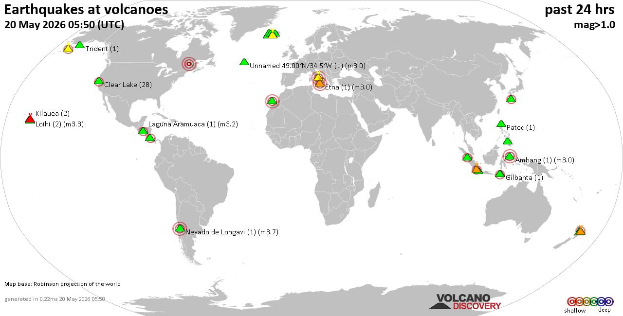 World map showing volcanoes with shallow (less than 50 km) earthquakes within 20 km radius during the past 24 hours on 20 May 2026 Number in brackets indicate nr of quakes. Quakes detected near: Ambang (1 quake mag 3.0), Bardarbunga (16 quakes between mag 0.0-1.6), Campi Flegrei (Phlegrean Fields) (4 quakes between mag 0.1-3.0), Chinameca (1 quake mag 2.3), Clear Lake (29 quakes between mag 0.3-2.0), Coso (1 quake mag 1.3)
Eldey (22 quakes between mag 0.1-2.0), Etna (1 quake mag 3.0), Gilbanta (1 quake mag 2.1), Katla (4 quakes between mag 0.5-1.5), Kilauea (2 quakes between mag 1.6-2.0), Kolumbo (1 quake mag 1.6), Krakatau (1 quake mag 2.9), Kuchinoshima (1 quake mag 2.8), Kupreanof (1 quake mag 1.1), Laguna Aramuaca (1 quake mag 3.2), Lanzarote (1 quake mag 3.0), Ljósufjöll (5 quakes between mag 0.1-2.0), Loihi (2 quakes between mag 2.1-3.3), Malindang (1 quake mag 1.9), Maunaloa (1 quake mag 2.5), Mayor Island (1 quake mag 2.5), Mayotte Island (1 quake mag 1.1), Okataina (Tarawera) (3 quakes between mag 1.5-2.0), Patoc (1 quake mag 1.4), Perbakti (1 quake mag 2.7), Prestahnukur (3 quakes between mag 0.8-1.1), San Cristobal (1 quake mag 2.3), Sangeang Api (3 quakes between mag 2.6-3.6), Talakmau (1 quake mag 2.1), Torfajökull (11 quakes between mag 0.2-1.1), Trident (1 quake mag 1.1), Turrialba (5 quakes between mag 1.7-2.5), Whale Island (1 quake mag 1.6) (updated 04h50)
Note: Earthquakes within 20 km from and at depths less than 50 km under active volcanoes are reported. The list is not complete because many volcanoes are not monitored and/or seismic data in high resolution is not available publicly.
Volcanoes with recent earthquakes above magnitude 2 or more than 10 quakes are listed below:
Ambang volcano (Sulawesi & Sangihe Islands): magnitude 3.0 earthquakeA magnitude 3.0 earthquake occurred at the volcano 14 hours ago. The quake, which might be volcanic in origin, was located at a depth of 12.00 km depth at 8 km distance NW from the volcano. Earthquake details: 3.0 quake Kota Kotamobagu, 92 km southwest of Manado, Indonesia, May 19, 2026 10:56 pm (GMT +8) (8 km NW) All earthquakes at AmbangBardarbunga volcano (Iceland): 16 earthquakes up to magnitude 1.6Possible earthquake swarm: 16 earthquakes occurred near (under) the volcano during 19 hours, the last being recorded quake 1 hour 35 minutes ago. Hypocenter depths ranged between 21.20 and 0.00 km. Earthquake details: (only 5 largest) 1.6 quake Iceland: 8.2 km ESE of Bárðarbunga May 19, 2026 04:38 pm (Reykjavik time) (8 km E) 1.5 quake 9.0 km E of Bárðarbunga May 19, 2026 07:24 pm (Universal Time) (9 km E) 1.5 quake 7.1 km ESE of Bárðarbunga May 19, 2026 01:52 pm (Universal Time) (7 km E) 1.0 quake 4.3 km E of Bárðarbunga May 19, 2026 01:52 pm (Universal Time) (5 km E) 0.8 quake Iceland: 2.5 km S of Bárðarbunga May 20, 2026 03:15 am (Reykjavik time) (1 km S) All earthquakes at BardarbungaCampi Flegrei (Phlegrean Fields) volcano (Italy): 4 earthquakes up to magnitude 3.04 earthquakes occurred near (under) the volcano during 21 hours, the last being recorded quake 1 hour 53 minutes ago. Hypocenter depths ranged between 10.00 and 0.03 km. Earthquake details: Reported seismic-like event (likely no quake): 6.2 km northwest of Naples, Napoli, Campania, Italy, May 19, 2026 10:46 pm (GMT +2) (11 km NE) 1.0 quake 2.9 km northwest of Bagnoli, Napoli, Campania, Italy, May 19, 2026 07:58 am (GMT +2) (1 km N) 0.1 quake 1.2 km north of Pozzuoli, Napoli, Campania, Italy, May 20, 2026 02:56 am (Universal Time) (5 km NW) 0.1 quake 10.5 km west of Naples, Napoli, Campania, Italy, May 19, 2026 06:01 am (Universal Time) (1 km NE) All earthquakes at Campi Flegrei (Phlegrean Fields)Chinameca volcano (El Salvador): magnitude 2.3 earthquakeA magnitude 2.3 earthquake occurred at the volcano 11 hours ago. The quake, which might be volcanic in origin, was located at a depth of 6.00 km depth at 12 km distance N from the volcano. Earthquake details: 2.3 quake 18 km northwest of San Miguel, Departamento de San Miguel, El Salvador, May 19, 2026 11:47 am (GMT -6) (12 km N) All earthquakes at ChinamecaClear Lake volcano (California): 29 earthquakes up to magnitude 2.0Possible earthquake swarm: 29 earthquakes occurred near (under) the volcano during 22 hours, the last being recorded quake 42 minutes ago. Hypocenter depths ranged between 7.55 and 0.21 km. Earthquake details: (only 5 largest) 2.0 quake Mendocino County, 13 mi southwest of Clearlake, Lake County, California, United States, May 19, 2026 05:43 pm (GMT -7) (14 km SSW) 1.3 quake 25 mi north of Santa Rosa, Sonoma County, California, United States, May 19, 2026 04:28 am (GMT -7) (19 km S) 1.3 quake 26 mi north of Santa Rosa, Sonoma County, California, United States, May 19, 2026 12:16 am (GMT -7) (17 km S) 1.3 quake Lake County, 28 mi north of Santa Rosa, Sonoma County, California, United States, May 19, 2026 02:05 pm (GMT -7) (15 km S) 1.1 quake 28 mi north of Santa Rosa, Sonoma County, California, United States, May 19, 2026 09:08 pm (GMT -7) (16 km SSW) All earthquakes at Clear LakeEldey volcano (Iceland): 22 earthquakes up to magnitude 2.0Possible earthquake swarm: 22 earthquakes occurred near (under) the volcano during 16 hours, the last being recorded quake 1 hour 31 minutes ago. Hypocenter depths ranged between 11.20 and 0.00 km. Earthquake details: (only 5 largest) 2.0 quake 9.1 km N of Eldey May 19, 2026 01:41 pm (Universal Time) (10 km N) 1.4 quake Iceland: 9.2 km NW of Reykjanestá May 19, 2026 03:35 pm (Reykjavik time) (17 km NNE) 1.3 quake 8.0 km N of Eldey May 19, 2026 11:18 am (Universal Time) (9 km N) 1.2 quake 7.6 km N of Eldey May 19, 2026 01:37 pm (Universal Time) (9 km N) 1.1 quake 8.0 km N of Eldey May 19, 2026 01:24 pm (Universal Time) (9 km N) All earthquakes at EldeyEldey is located at the beginning of the Reykjanes Ridge off the SW tip of Iceland. Its highest elevation is the top of Eldey Island, but most of the volcanic edifice is submerged. Several eruptions occurred in historic times, last in 1926. Etna volcano (Italy): magnitude 3.0 earthquakeA magnitude 3.0 earthquake occurred at the volcano 22 hours ago. The quake, which might be volcanic in origin, was located at a depth of 10.00 km depth at 0 km distance SW from the volcano. Earthquake details: Reported seismic-like event (likely no quake): 30 km north of Catania, Catania, Sicily, Italy, May 19, 2026 09:18 am (GMT +2) (0 km SW) All earthquakes at EtnaGilbanta volcano (Lesser Sunda Islands): magnitude 2.1 earthquakeA magnitude 2.1 earthquake occurred at the volcano 16 hours ago. The quake, which might be volcanic in origin, was located at a depth of 10.00 km depth at 19 km distance W from the volcano. Earthquake details: 2.1 quake Selat Sumba, 16 km west of Gili Banta Island, West Nusa Tenggara, Indonesia, May 19, 2026 08:46 pm (GMT +8) (19 km W) All earthquakes at GilbantaKrakatau volcano (Sunda Strait): magnitude 2.9 earthquakeA magnitude 2.9 earthquake occurred at the volcano 11 hours ago. The quake, which might be volcanic in origin, was located at a depth of 3.00 km depth at 12 km distance SW from the volcano. Earthquake details: 2.9 quake Indian Ocean, 31 km southwest of Pulau Sebesi Island, Lampung, Indonesia, May 20, 2026 12:55 am (GMT +7) (12 km SW) All earthquakes at KrakatauKuchinoshima volcano (Ryukyu Islands): magnitude 2.8 earthquakeA magnitude 2.8 earthquake occurred at the volcano 18 hours ago. The quake, which might be volcanic in origin, was located at a depth of 10.00 km depth at 8 km distance ENE from the volcano. Earthquake details: 2.8 quake East China Sea, Kagoshima-ken, 49 km northeast of Suwanose-jima Island, Japan, May 19, 2026 07:35 pm (GMT +9) (8 km ENE) All earthquakes at KuchinoshimaLaguna Aramuaca volcano (El Salvador): magnitude 3.2 earthquakeA magnitude 3.2 earthquake occurred at the volcano 15 hours ago. The quake, which might be volcanic in origin, was located at a depth of 4.60 km depth at 12 km distance S from the volcano. Earthquake details: 3.2 quake 20 km southeast of San Miguel, Departamento de San Miguel, El Salvador, May 19, 2026 07:22 am (GMT -6) (12 km S) All earthquakes at Laguna AramuacaLanzarote volcano (Canary Islands): magnitude 3.0 earthquakeA magnitude 3.0 earthquake occurred at the volcano 9 hours ago. The quake, which might be volcanic in origin, was located at a depth of 10.00 km depth at 12 km distance ESE from the volcano. Earthquake details: Reported seismic-like event (likely no quake): 9.2 km west of Arrecife, Las Palmas, Canary Islands, Spain, May 19, 2026 08:28 pm (GMT +1) (12 km ESE) All earthquakes at LanzaroteLoihi volcano (Hawai'i (Big Island)): 2 earthquakes up to magnitude 3.32 earthquakes occurred near (under) the volcano during 14 hours, the last being recorded quake 6 hours ago. Hypocenter depths ranged between 36.05 and 10.37 km. Earthquake details: 3.3 quake North Pacific Ocean, 60 mi south of Hilo, Hawaii County, Hawaii, United States, May 18, 2026 11:10 pm (GMT -10) (8 km SE) 2.1 quake North Pacific Ocean, 24 mi east of Hawaiian Ocean View, Hawaii County, Hawaii, United States, May 19, 2026 01:08 pm (GMT -10) (19 km NW) All earthquakes at LoihiMaunaloa volcano (Hawai'i (Big Island)): magnitude 2.5 earthquakeA magnitude 2.5 earthquake occurred at the volcano 18 hours ago. The quake, which might be volcanic in origin, was located at a depth of 0.56 km depth at 16 km distance E from the volcano. Earthquake details: 2.5 quake 30 mi southwest of Hilo, Hawaii County, Hawaii, United States, May 19, 2026 12:32 am (GMT -10) (16 km E) All earthquakes at MaunaloaMayor Island volcano (New Zealand): magnitude 2.5 earthquakeA magnitude 2.5 earthquake occurred at the volcano 20 hours ago. The quake, which might be volcanic in origin, was located at a depth of 21.70 km depth at 17 km distance NE from the volcano. Earthquake details: 2.5 quake South Pacific Ocean, 60 km north of Tauranga, Bay of Plenty, New Zealand, May 19, 2026 08:37 pm (GMT +12) (17 km NE) All earthquakes at Mayor IslandPerbakti volcano (West Java): magnitude 2.7 earthquakeA magnitude 2.7 earthquake occurred at the volcano 18 hours ago. The quake, which might be volcanic in origin, was located at a depth of 19.00 km depth at 18 km distance SE from the volcano. Earthquake details: 2.7 quake 9.3 km south of Cicurug, Kabupaten Sukabumi, Jawa Barat, Indonesia, May 19, 2026 05:50 pm (GMT +7) (18 km SE) All earthquakes at PerbaktiSan Cristobal volcano (Nicaragua): magnitude 2.3 earthquakeA magnitude 2.3 earthquake occurred at the volcano 23 hours ago. The quake, which might be volcanic in origin, was located at a depth of 7.00 km depth at 3 km distance NW from the volcano. Earthquake details: 2.3 quake 16 km northeast of Chinandega, Departamento de Chinandega, Nicaragua, May 18, 2026 11:36 pm (GMT -6) (3 km NW) All earthquakes at San CristobalSangeang Api volcano (Lesser Sunda Islands): 3 earthquakes up to magnitude 3.63 earthquakes occurred near (under) the volcano during 14 hours, the last being recorded quake 32 minutes ago. Hypocenter depths ranged between 12.00 and 10.00 km. Earthquake details: 3.6 quake Flores Sea, 16 km east of Pulau Sangeang Island, West Nusa Tenggara, Indonesia, May 20, 2026 12:17 pm (GMT +8) (15 km E) 2.8 quake Flores Sea, 19 km northeast of Pulau Sangeang Island, Indonesia, May 19, 2026 10:28 pm (GMT +8) (19 km NE) 2.6 quake Flores Sea, 18 km northeast of Pulau Sangeang Island, Indonesia, May 20, 2026 05:13 am (GMT +8) (18 km ENE) All earthquakes at Sangeang ApiTalakmau volcano (Sumatra): magnitude 2.1 earthquakeA magnitude 2.1 earthquake occurred at the volcano 33 minutes ago. The quake, which might be volcanic in origin, was located at a depth of 10.00 km depth at 3 km distance ESE from the volcano. Earthquake details: 2.1 quake Kabupaten Pasaman, 58 km northwest of Bukittinggi, Indonesia, May 20, 2026 11:16 am (GMT +7) (3 km ESE) All earthquakes at TalakmauTorfajökull volcano (Iceland): 11 earthquakes up to magnitude 1.1Possible earthquake swarm: 11 earthquakes occurred near (under) the volcano during 11 hours, the last being recorded quake 11 hours ago. Hypocenter depths ranged between 0.80 and 0.00 km. Earthquake details: (only 5 largest) 1.1 quake 6.5 km NNW of Álftavatn May 19, 2026 04:13 pm (Universal Time) (5 km WSW) 1.0 quake Iceland: 7.6 km SE of Álftavatn May 19, 2026 07:02 am (Reykjavik time) (14 km SSE) 0.8 quake 11.5 km NNW of Álftavatn May 19, 2026 01:34 pm (Universal Time) (6 km WNW) 0.8 quake 10.9 km NNW of Álftavatn May 19, 2026 11:19 am (Universal Time) (6 km WNW) 0.5 quake Iceland: 10.3 km N of Álftavatn May 19, 2026 06:07 pm (Reykjavik time) (4 km WNW) All earthquakes at TorfajökullTurrialba volcano (Costa Rica): 5 earthquakes up to magnitude 2.55 earthquakes occurred near (under) the volcano during 1 hour 59 minutes, the last being recorded quake 18 hours ago. Hypocenter depths ranged between 5.00 and 4.00 km. Earthquake details: 2.5 quake 12 km north of Turrialba, Provincia de Cartago, Costa Rica, May 19, 2026 03:18 am (GMT -6) (10 km ESE) 2.2 quake 12 km north of Turrialba, Provincia de Cartago, Costa Rica, May 19, 2026 03:17 am (Costa_Rica time) (11 km E) 2.1 quake 12 km north of Turrialba, Provincia de Cartago, Costa Rica, May 19, 2026 05:12 am (Costa_Rica time) (9 km E) 2.0 quake 12 km northwest of Turrialba, Provincia de Cartago, Costa Rica, May 19, 2026 03:13 am (Costa_Rica time) (5 km SE) 1.7 quake 12 km north of Turrialba, Provincia de Cartago, Costa Rica, May 19, 2026 04:52 am (Costa_Rica time) (10 km E) All earthquakes at TurrialbaUnnamed 49.00°N/34.5°W volcano (Atlantic Ocean): magnitude 3.0 earthquakeA magnitude 3.0 earthquake occurred at the volcano 4 hours ago. The quake, which might be volcanic in origin, was located at a depth of 10.00 km depth at 15 km distance WNW from the volcano. Earthquake details: Uncertain quake: M3.0, 15 km southeast of Saguenay, Saguenay/Lac-Saint-Jean, Quebec, Canada, May 19, 2026 08:21 pm (GMT -4) (15 km WNW) All earthquakes at Unnamed 49.00°N/34.5°Whttps://www.volcanodiscovery.com/earthquakes-volcanoes/news/302925/Volcano-earthquake-report-for-Wednesday-20-May-2026.html
|
|


CMS The Best Conveyancing solicitors conveyancing quotes throughout the UK
For any webhosting enquiries please email webmaster@aus-city.com
|
|
Entire Thread
|
 Volcano earthquake report for Wednesday, 20 May 2026
|
Webmaster
|
Wed 20 May 2026 04:50:AM
|
|
Forums60
Topics784,872
Posts819,639
Members2,960
| |
Most Online22,463
May 9th, 2026
|
|
|
|
|
Copyright 1996 - 2026 by David Cottle. Designed by David Bate Jr. All Rights Reserved.
By using this forum, the user agrees not to transfer any data or technical information received under this agreement to any other entity without the express approval of the AUS-CITY Forum Admins and/or authors of individual posts (Forum Admins and DoD/USSPACECOM for the analysis of satellite tracking data).
Two-line elements (TLE) and all other satellite data presented and distributed via this forum and AUS-CITY mailing lists are distributed with permission from DoD/USSTRATCOM.

|

|


 - Click image for larger picture.")


