|
|
|
2 members (Webmaster, Alisa),
1,369
guests, and
26
robots. |
|
Key:
Admin,
Global Mod,
Mod
|
|
S |
M |
T |
W |
T |
F |
S |
|
|
|
|
|
|
1
|
2
|
|
3
|
4
|
5
|
6
|
7
|
8
|
9
|
|
10
|
11
|
12
|
13
|
14
|
15
|
16
|
|
17
|
18
|
19
|
20
|
21
|
22
|
23
|
|
24
|
25
|
26
|
27
|
28
|
29
|
30
|
|
31
|
|
|
|
|
|
|
|
There are no members with birthdays on this day. |
|
|
|
|
|
|
|
|
|
|
|
|
|
|
SPC MD 805
by Webmaster - Wed 20 May 2026 08:43:PM
|
SPC MD 806
by Webmaster - Wed 20 May 2026 08:43:PM
|
|
|

World Earthquake Report for Wednesday, 20 May 2026
• Volcano earthquake report for Wednesday, 20 May 2026
• Moderate mag. 4.2 earthquake - 57 km north of Tingo Maria, Region de Huanuc...
• Moderate mag. 4.0 earthquake - Kabupaten Luwu Timur, 70 km east of Masamba,...
• Strong mag. 5.0 earthquake - Southern East Pacific Rise on Wednesday, May 2...
• Magnitude 3.5 earthquake strikes near Tellebang, North Burnett, Queensland,...
|
|
|
Joined: Feb 2001
Posts: 381,904
Launch Director
|
OP

Launch Director
Joined: Feb 2001
Posts: 381,904 |
Volcano earthquake report for Wednesday, 20 May 2026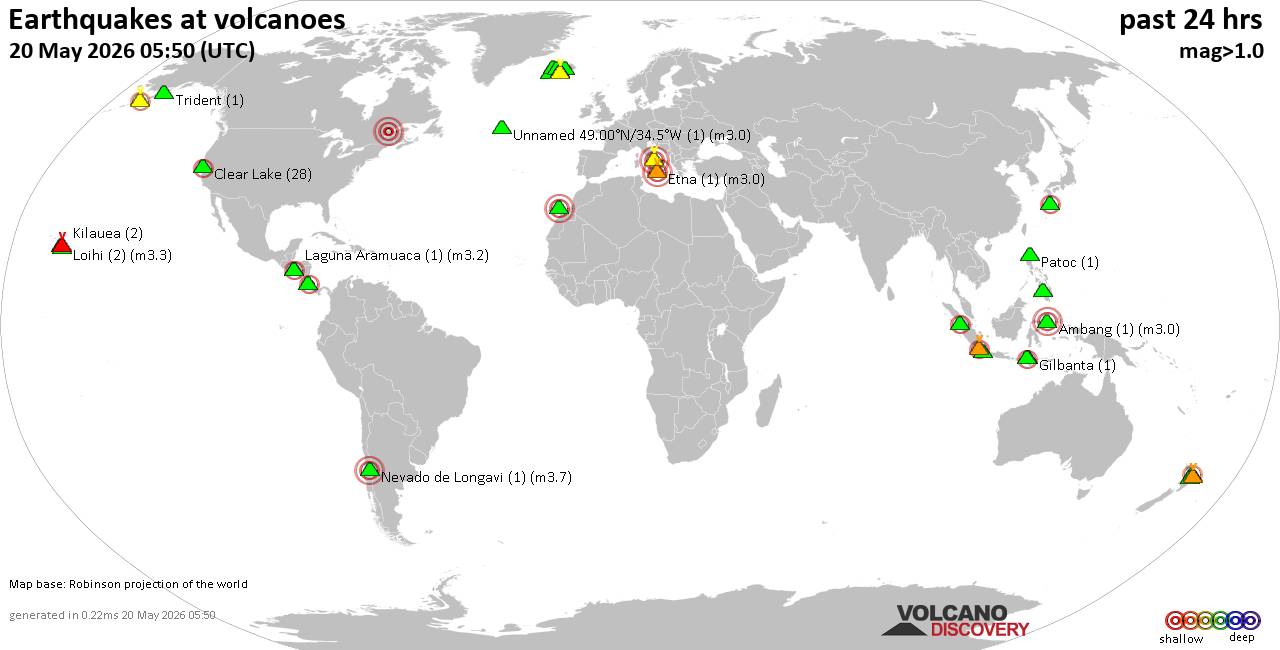 World map showing volcanoes with shallow (less than 50 km) earthquakes within 20 km radius during the past 24 hours on 20 May 2026 Number in brackets indicate nr of quakes. Quakes detected near: Bardarbunga (17 quakes between mag 0.1-1.6), Campi Flegrei (Phlegrean Fields) (5 quakes between mag 0.1-3.0), Clear Lake (26 quakes between mag 0.3-2.0), Coso (2 quakes between mag 0.3-1.4), Eldey (6 quakes between mag 0.5-1.0), Gilbanta (1 quake mag 5.2)
Hulubelu (1 quake mag 2.0), Katla (4 quakes between mag 0.0-1.5), Kenger (1 quake mag 1.0), Kilauea (1 quake mag 1.7), Kyejo (1 quake mag 2.9), Loihi (2 quakes between mag 1.8-2.1), Maunaloa (1 quake mag 2.6), Natib (1 quake mag 3.0), Nevado de Longavi (3 quakes between mag 2.8-3.7), Okataina (Tarawera) (1 quake mag 1.5), Prestahnukur (27 quakes between mag 0.5-2.2), Reporoa (1 quake mag 1.4), Sangeang Api (17 quakes between mag 2.0-3.5), Talakmau (1 quake mag 2.1), Tenerife (2 quakes between mag 0.8-1.0), Torfajökull (9 quakes between mag 0.0-1.0), White Island (4 quakes between mag 2.1-2.9) (updated 19h50)
Note: Earthquakes within 20 km from and at depths less than 50 km under active volcanoes are reported. The list is not complete because many volcanoes are not monitored and/or seismic data in high resolution is not available publicly.
Volcanoes with recent earthquakes above magnitude 2 or more than 10 quakes are listed below:
Bardarbunga volcano (Iceland): 17 earthquakes up to magnitude 1.6Possible earthquake swarm: 17 earthquakes occurred near (under) the volcano during 18 hours, the last being recorded quake 4 hours ago. Hypocenter depths ranged between 21.20 and 0.00 km. Earthquake details: (only 5 largest) 1.6 quake 7.4 km E of Bárðarbunga May 20, 2026 06:31 am (Universal Time) (8 km E) 1.0 quake 3.9 km ESE of Bárðarbunga May 20, 2026 03:28 pm (Universal Time) (4 km E) 1.0 quake 1.0 km SSE of Bárðarbunga May 20, 2026 05:24 am (Universal Time) (1 km ENE) 0.9 quake Iceland: 4.9 km E of Bárðarbunga May 20, 2026 05:11 am (Reykjavik time) (5 km E) 0.8 quake Iceland: 2.5 km S of Bárðarbunga May 20, 2026 03:15 am (Reykjavik time) (1 km S) All earthquakes at BardarbungaCampi Flegrei (Phlegrean Fields) volcano (Italy): 5 earthquakes up to magnitude 3.05 earthquakes occurred near (under) the volcano during 22 hours, the last being recorded quake 1 hour 14 minutes ago. Hypocenter depths ranged between 10.00 and 0.03 km. Earthquake details: Reported seismic-like event (likely no quake): 6.2 km northwest of Naples, Napoli, Campania, Italy, May 19, 2026 10:46 pm (GMT +2) (11 km NE) 0.5 quake 3.7 km east of Pozzuoli, Napoli, Campania, Italy, May 20, 2026 08:36 pm (GMT +2) (1 km NNW) 0.4 quake 3 km southeast of Pozzuoli, Napoli, Campania, Italy, May 20, 2026 10:16 am (GMT +2) (2 km W) 0.1 quake 1.2 km northwest of Bagnoli, Napoli, Campania, Italy, May 20, 2026 05:33 pm (Universal Time) (2 km ESE) 0.1 quake 1.2 km north of Pozzuoli, Napoli, Campania, Italy, May 20, 2026 02:56 am (Universal Time) (5 km NW) All earthquakes at Campi Flegrei (Phlegrean Fields)Clear Lake volcano (California): 26 earthquakes up to magnitude 2.0Possible earthquake swarm: 26 earthquakes occurred near (under) the volcano during 22 hours, the last being recorded quake 58 minutes ago. Hypocenter depths ranged between 7.55 and 0.21 km. Earthquake details: (only 5 largest) 2.0 quake Mendocino County, 13 mi southwest of Clearlake, Lake County, California, United States, May 19, 2026 05:43 pm (GMT -7) (14 km SSW) 1.6 quake 12 mi southwest of Clearlake, Lake County, California, United States, May 20, 2026 11:52 am (GMT -7) (15 km S) 1.5 quake 13 mi southwest of Clearlake, Lake County, California, United States, May 20, 2026 03:05 am (GMT -7) (19 km S) 1.3 quake 28 mi north of Santa Rosa, Sonoma County, California, United States, May 20, 2026 07:32 am (GMT -7) (16 km SSW) 1.3 quake Lake County, 28 mi north of Santa Rosa, Sonoma County, California, United States, May 19, 2026 02:05 pm (GMT -7) (15 km S) All earthquakes at Clear LakeGilbanta volcano (Lesser Sunda Islands): magnitude 5.2 earthquakeA magnitude 5.2 earthquake occurred at the volcano 9 hours ago. The quake, which might be volcanic in origin, was located at a depth of 10.00 km depth at 16 km distance NNW from the volcano. Earthquake details: 5.2 quake Flores Sea, 17 km east of Pulau Sangeang Island, West Nusa Tenggara, Indonesia, May 20, 2026 06:28 pm (Makassar time) (16 km NNW) All earthquakes at GilbantaKyejo volcano (Tanzania): magnitude 2.9 earthquakeA magnitude 2.9 earthquake occurred at the volcano 9 hours ago. The quake, which might be volcanic in origin, was located at a depth of 10.00 km depth at 5 km distance SSW from the volcano. Earthquake details: 2.9 quake South Africa May 20, 2026 12:49 pm (GMT +2) (5 km SSW) All earthquakes at KyejoLoihi volcano (Hawai'i (Big Island)): 2 earthquakes up to magnitude 2.12 earthquakes occurred near (under) the volcano during 18 hours, the last being recorded quake 3 hours ago. Hypocenter depths ranged between 36.05 and 34.97 km. Earthquake details: 2.1 quake North Pacific Ocean, 24 mi east of Hawaiian Ocean View, Hawaii County, Hawaii, United States, May 19, 2026 01:08 pm (GMT -10) (19 km NW) 1.8 quake North Pacific Ocean, 41 mi southeast of of Hawai‘i Island, Hawaii County, Hawaii, United States, May 20, 2026 06:57 am (GMT -10) (15 km NNW) All earthquakes at LoihiMaunaloa volcano (Hawai'i (Big Island)): magnitude 2.6 earthquakeA magnitude 2.6 earthquake occurred at the volcano 16 hours ago. The quake, which might be volcanic in origin, was located at a depth of 1.65 km depth at 8 km distance S from the volcano. Earthquake details: 2.6 quake 26 mi southeast of Holualoa, Hawaii County, Hawaii, United States, May 19, 2026 05:57 pm (GMT -10) (8 km S) All earthquakes at MaunaloaNatib volcano (Luzon Island): magnitude 3.0 earthquakeA magnitude 3.0 earthquake occurred at the volcano 4 hours ago. The quake, which might be volcanic in origin, was located at a depth of 10.00 km depth at 17 km distance NNE from the volcano. Earthquake details: Reported seismic-like event (likely no quake): 30 km southwest of San Fernando, Philippines, May 21, 2026 12:13 am (GMT +8) (17 km NNE) All earthquakes at NatibNevado de Longavi volcano (Central Chile and Argentina): 3 earthquakes up to magnitude 3.73 earthquakes occurred near (under) the volcano during 7 hours, the last being recorded quake 8 hours ago. Hypocenter depths ranged between 7.80 and 6.80 km. Earthquake details: 3.7 quake 51 km southeast of Linares, Provincia de Linares, Region del Maule, Chile, May 20, 2026 12:49 am (GMT -4) (7 km WSW) 3.4 quake 51 km southeast of Linares, Provincia de Linares, Region del Maule, Chile, May 20, 2026 07:33 am (GMT -4) (11 km WSW) 2.8 quake 47 km southeast of Linares, Provincia de Linares, Region del Maule, Chile, May 20, 2026 07:22 am (GMT -4) (11 km W) All earthquakes at Nevado de LongaviPrestahnukur volcano (Iceland): 27 earthquakes up to magnitude 2.2Possible earthquake swarm: 27 earthquakes occurred near (under) the volcano during 17 hours, the last being recorded quake 3 hours ago. Hypocenter depths ranged between 12.90 and 0.10 km. Earthquake details: (only 5 largest) 2.2 quake 15.4 km SSE of Húsafell May 20, 2026 09:41 am (Universal Time) (12 km WSW) 1.9 quake 15.5 km SSE of Húsafell May 20, 2026 06:35 am (Universal Time) (11 km WSW) 1.8 quake 15.2 km SSE of Húsafell May 20, 2026 09:43 am (Universal Time) (11 km WSW) 1.8 quake 15.3 km SSE of Húsafell May 20, 2026 07:05 am (Universal Time) (12 km WSW) 1.6 quake 15.6 km SSE of Húsafell May 20, 2026 07:23 am (Universal Time) (12 km WSW) All earthquakes at PrestahnukurSangeang Api volcano (Lesser Sunda Islands): 17 earthquakes up to magnitude 3.5Possible earthquake swarm: 17 earthquakes occurred near (under) the volcano during 22 hours, the last being recorded quake 42 minutes ago. Hypocenter depths ranged between 13.00 and 9.00 km. Earthquake details: (only 5 largest) 3.5 quake Flores Sea, 17 km northeast of Pulau Sangeang Island, Indonesia, May 20, 2026 12:17 pm (GMT +8) (17 km NE) 3.4 quake Flores Sea, 16 km east of Pulau Sangeang Island, West Nusa Tenggara, Indonesia, May 20, 2026 06:33 pm (GMT +8) (16 km ENE) 2.9 quake Flores Sea, 14 km east of Pulau Sangeang Island, West Nusa Tenggara, Indonesia, May 20, 2026 07:02 pm (GMT +8) (14 km ENE) 2.8 quake Flores Sea, 18 km northeast of Pulau Sangeang Island, Indonesia, May 21, 2026 01:30 am (GMT +8) (17 km NE) 2.6 quake Flores Sea, 18 km northeast of Pulau Sangeang Island, Indonesia, May 20, 2026 05:13 am (GMT +8) (18 km ENE) All earthquakes at Sangeang ApiTalakmau volcano (Sumatra): magnitude 2.1 earthquakeA magnitude 2.1 earthquake occurred at the volcano 16 hours ago. The quake, which might be volcanic in origin, was located at a depth of 10.00 km depth at 3 km distance ESE from the volcano. Earthquake details: 2.1 quake Kabupaten Pasaman, 58 km northwest of Bukittinggi, Indonesia, May 20, 2026 11:16 am (GMT +7) (3 km ESE) All earthquakes at TalakmauUnnamed 49.00°N/34.5°W volcano (Atlantic Ocean): magnitude 3.0 earthquakeA magnitude 3.0 earthquake occurred at the volcano 19 hours ago. The quake, which might be volcanic in origin, was located at a depth of 10.00 km depth at 15 km distance WNW from the volcano. Earthquake details: Uncertain quake: M3.0, 15 km southeast of Saguenay, Saguenay/Lac-Saint-Jean, Quebec, Canada, May 19, 2026 08:21 pm (GMT -4) (15 km WNW) All earthquakes at Unnamed 49.00°N/34.5°WWhite Island volcano (New Zealand): 4 earthquakes up to magnitude 2.94 earthquakes occurred near (under) the volcano during 12 hours, the last being recorded quake 37 minutes ago. Hypocenter depths ranged between 5.00 and 2.00 km. Earthquake details: 2.9 quake South Pacific Ocean, 53 km north of Whakatane, Bay of Plenty, New Zealand, May 20, 2026 07:14 pm (GMT +12) (3 km NW) 2.6 quake South Pacific Ocean, 69 km north of Whakatane, Bay of Plenty, New Zealand, May 21, 2026 01:44 am (GMT +12) (18 km NNE) 2.4 quake South Pacific Ocean, 70 km north of Whakatane, Bay of Plenty, New Zealand, May 21, 2026 07:13 am (GMT +12) (19 km N) 2.1 quake South Pacific Ocean, 49 km north of Whakatane, Bay of Plenty, New Zealand, May 20, 2026 08:50 pm (GMT +12) (3 km SW) All earthquakes at White Islandhttps://www.volcanodiscovery.com/earthquakes-volcanoes/news/302925/Volcano-earthquake-report-for-Wednesday-20-May-2026.html
|
|


CMS The Best Conveyancing solicitors conveyancing quotes throughout the UK
For any webhosting enquiries please email webmaster@aus-city.com
|
|
Entire Thread
|

 Volcano earthquake report for Wednesday, 20 May 2026
|
Webmaster
|
3 hours ago
|
|
Forums60
Topics775,832
Posts810,625
Members2,960
| |
Most Online22,463
May 9th, 2026
|
|
|
|
|
Copyright 1996 - 2026 by David Cottle. Designed by David Bate Jr. All Rights Reserved.
By using this forum, the user agrees not to transfer any data or technical information received under this agreement to any other entity without the express approval of the AUS-CITY Forum Admins and/or authors of individual posts (Forum Admins and DoD/USSPACECOM for the analysis of satellite tracking data).
Two-line elements (TLE) and all other satellite data presented and distributed via this forum and AUS-CITY mailing lists are distributed with permission from DoD/USSTRATCOM.

|

|


 - Click image for larger picture.")


