|
1 members (Alisa),
1,512
guests, and
22
robots. |
|
Key:
Admin,
Global Mod,
Mod
|
|
S |
M |
T |
W |
T |
F |
S |
|
|
1
|
2
|
3
|
4
|
5
|
6
|
|
7
|
8
|
9
|
10
|
11
|
12
|
13
|
|
14
|
15
|
16
|
17
|
18
|
19
|
20
|
|
21
|
22
|
23
|
24
|
25
|
26
|
27
|
|
28
|
29
|
30
|
|
|
|
|
|
There are no members with birthdays on this day. |

Volcano earthquake report for Monday, 29 Jun 2026
• World Earthquake Report for Monday, 29 June 2026
• Moderate mag. 4.8 earthquake - South of the Fiji Islands on Tuesday, Jun 30...
• Magnitude 4.0 earthquake strikes near Kodiak, Kodiak Island, Alaska, USA
• Light mag. 3.9 earthquake - 51 km NNE of Aleneva, Alaska, on Monday, Jun 29...
• Moderate mag. 4.2 earthquake - Northern Molucca Sea on Monday, Jun 29, 2026...
|

#812535
Wed 20 May 2026 08:39:PM
|
Joined: Feb 2001
Posts: 678,976
Launch Director
|
OP

Launch Director
Joined: Feb 2001
Posts: 678,976 |
SPC Severe Thunderstorm Watch 237WW 237 SEVERE TSTM TX 202015Z - 210300Z 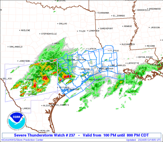
URGENT - IMMEDIATE BROADCAST REQUESTED
Severe Thunderstorm Watch Number 237
NWS Storm Prediction Center Norman OK
315 PM CDT Wed May 20 2026

The NWS Storm Prediction Center has issued a

* Severe Thunderstorm Watch for portions of
  Southwest Texas

* Effective this Wednesday afternoon and evening from 315 PM
  until 1000 PM CDT.

* Primary threats include...
  Scattered large hail and isolated very large hail events to 2
    inches in diameter likely
  Scattered damaging wind gusts to 70 mph possible
  A tornado or two possible

SUMMARY...Intense thunderstorms will develop off the Davis Mountains
and spread eastward this afternoon and evening, posing a risk of
large hail and damaging wind gusts.

The severe thunderstorm watch area is approximately along and 60
statute miles north and south of a line from 15 miles south
southwest of Marfa TX to 35 miles east northeast of Dryden TX. For a
complete depiction of the watch see the associated watch outline
update (WOUS64 KWNS WOU7).

PRECAUTIONARY/PREPAREDNESS ACTIONS...

REMEMBER...A Severe Thunderstorm Watch means conditions are
favorable for severe thunderstorms in and close to the watch area.
Persons in these areas should be on the lookout for threatening
weather conditions and listen for later statements and possible
warnings. Severe thunderstorms can and occasionally do produce
tornadoes.

&&

OTHER WATCH INFORMATION...CONTINUE...WW 234...WW 235...WW 236...

AVIATION...A few severe thunderstorms with hail surface and aloft to
2 inches. Extreme turbulence and surface wind gusts to 60 knots. A
few cumulonimbi with maximum tops to 500. Mean storm motion vector
25025.

...Hart
Read morehttps://www.spc.noaa.gov/products/watch/ww0237.html
|
|


CMS The Best Conveyancing solicitors conveyancing quotes throughout the UK
For any webhosting enquiries please email webmaster@aus-city.com
|
|
Entire Thread
|
 SPC Severe Thunderstorm Watch 237
|
Webmaster
|
Wed 20 May 2026 08:39:PM
|
|
Forums60
Topics785,111
Posts819,880
Members2,960
| |
Most Online22,463
May 9th, 2026
|
|
|


 - Click image for larger picture.")


