|
|
|
0 members (),
1,194
guests, and
29
robots. |
|
Key:
Admin,
Global Mod,
Mod
|
|
S |
M |
T |
W |
T |
F |
S |
|
|
|
|
|
|
1
|
2
|
|
3
|
4
|
5
|
6
|
7
|
8
|
9
|
|
10
|
11
|
12
|
13
|
14
|
15
|
16
|
|
17
|
18
|
19
|
20
|
21
|
22
|
23
|
|
24
|
25
|
26
|
27
|
28
|
29
|
30
|
|
31
|
|
|
|
|
|
|
|
There are no members with birthdays on this day. |
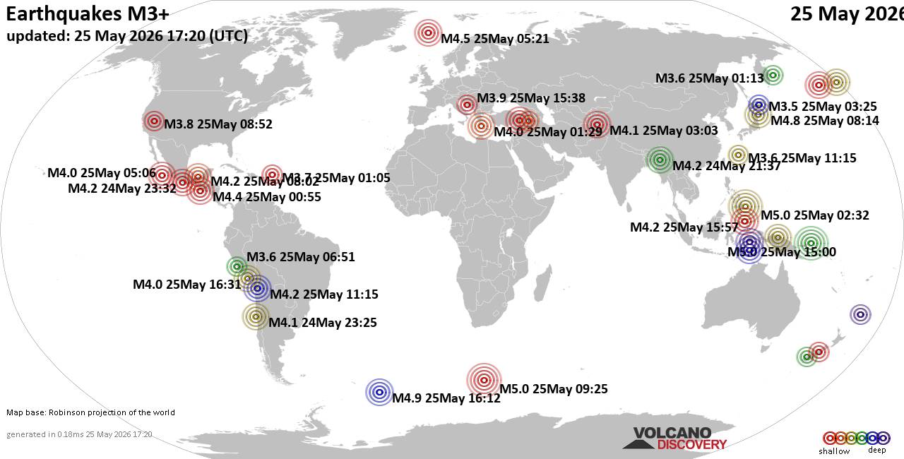
World Earthquake Report for Monday, 25 May 2026
• Moderate mag. 4.1 earthquake - 80 km northwest of Galela, Kabupaten Halmahe...
• Moderate magnitude 4.5 quake hits 102 km northeast of Manokwari, Indonesia ...
• Volcano earthquake report for Monday, 25 May 2026
• Moderate mag. 4.8 earthquake - South Pacific Ocean, 89 km northeast of Mano...
• Moderate mag. 4.0 earthquake - South Pacific Ocean, 81 km southwest of Moll...
|
|
|
Joined: Feb 2001
Posts: 381,904
Launch Director
|
OP

Launch Director
Joined: Feb 2001
Posts: 381,904 |
SPC May 25, 2026 1730 UTC Day 2 Convective OutlookSPC 1730Z Day 2 Outlook 
Day 2 Convective Outlook
NWS Storm Prediction Center Norman OK
1232 PM CDT Mon May 25 2026

Valid 261200Z - 271200Z

...THERE IS A SLIGHT RISK OF SEVERE THUNDERSTORMS ACROSS
WEST/SOUTHWEST TEXAS...

...SUMMARY...
Scattered severe storms will be possible across West/southwest Texas
into south-central Texas Tuesday afternoon and night, including
potential for large hail, damaging winds and a couple tornadoes.

...Eastern New Mexico and West/south-central Texas...
Forcing for ascent will arrive into the region Tuesday afternoon via
a lead shortwave trough, with increasing thunderstorm development
expected from the Davis Mountains to the Edwards Plateau and to the
southern Permian Basin. Moderate instability and steep low to
mid-level lapse rates are forecast across the region, with
increasing deep layer shear to around 30-40 kt. Mode will likely
include initially discrete supercells and multicell clusters capable
of large to very large hail and severe wind gusts, along with a
tornado risk as low-level winds/SRH increase particularly late in
the day across parts of the Permian Basin. Storms should grow
upscale by evening as they progress east-southeastward Tuesday night
toward south-central Texas with at least some continued severe
potential.

...Montana/Northern Intermountain West...
Scattered thunderstorms are expected Tuesday afternoon into evening,
aided by forcing for ascent related to the amplifying upper trough
and the upper-jet exit region. Modest instability and strengthening
deep layer shear amid deeply mixed profiles may allow for a few
stronger storms with potential for marginally severe hail and
locally severe wind gusts.

...Upper Midwest including parts of Wisconsin/Minnesota...
While influenced by upper ridging and weak overall forcing for
ascent, a moist/moderately unstable environment will exist
along/south of generally southward-shifting front. Isolated to
widely scattered thunderstorm development is plausible particularly
into peak heating. Diurnally steepening low-level lapse rates,
upwards of 1500-2500 J/kg MLCAPE within a weak vertical shear (20-30
kt effective) could yield some pulse-type/multicellular storms
capable of marginally severe hail and/or locally damaging winds.

...Northern Maine...
As a shortwave trough/mid-level jet streak approaches from Quebec, a
few strong or locally severe storms could develop into the region
Tuesday late afternoon or early evening. Some questions linger
regarding the degree of destabilization of timing of relevant
features, but this will be reevaluated into the Day 1 time frame for
a potential need for severe probabilities.

..Guyer.. 05/25/2026
Read morehttps://www.spc.noaa.gov/products/outlook/day2otlk_1730.html
|
|



CMS The Best Conveyancing solicitors conveyancing quotes throughout the UK
For any webhosting enquiries please email webmaster@aus-city.com
|
|
Entire Thread
|

 SPC May 25, 2026 1730 UTC Day 2 Convective Outlook
|
Webmaster
|
5 hours ago
|
|
Forums60
Topics776,601
Posts811,397
Members2,960
| |
Most Online22,463
May 9th, 2026
|
|
|
|
|
Copyright 1996 - 2026 by David Cottle. Designed by David Bate Jr. All Rights Reserved.
By using this forum, the user agrees not to transfer any data or technical information received under this agreement to any other entity without the express approval of the AUS-CITY Forum Admins and/or authors of individual posts (Forum Admins and DoD/USSPACECOM for the analysis of satellite tracking data).
Two-line elements (TLE) and all other satellite data presented and distributed via this forum and AUS-CITY mailing lists are distributed with permission from DoD/USSTRATCOM.

|

|