|
0 members (),
1,455
guests, and
25
robots. |
|
Key:
Admin,
Global Mod,
Mod
|
|
S |
M |
T |
W |
T |
F |
S |
|
|
|
|
|
|
1
|
2
|
|
3
|
4
|
5
|
6
|
7
|
8
|
9
|
|
10
|
11
|
12
|
13
|
14
|
15
|
16
|
|
17
|
18
|
19
|
20
|
21
|
22
|
23
|
|
24
|
25
|
26
|
27
|
28
|
29
|
30
|
|
31
|
|
|
|
|
|
|
|
There are no members with birthdays on this day. |
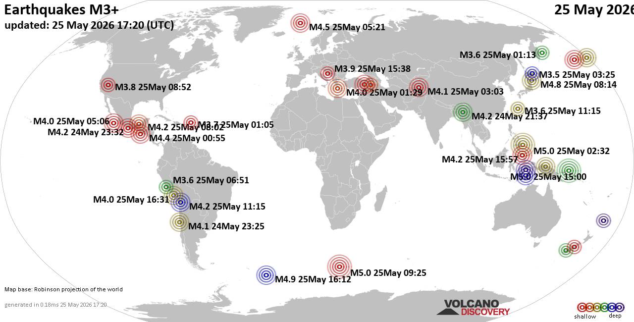
World Earthquake Report for Monday, 25 May 2026
• Moderate mag. 4.1 earthquake - 80 km northwest of Galela, Kabupaten Halmahe...
• Moderate magnitude 4.5 quake hits 102 km northeast of Manokwari, Indonesia ...
• Volcano earthquake report for Monday, 25 May 2026
• Moderate mag. 4.8 earthquake - South Pacific Ocean, 89 km northeast of Mano...
• Moderate mag. 4.0 earthquake - South Pacific Ocean, 81 km southwest of Moll...
|
|
|
Joined: Feb 2001
Posts: 381,904
Launch Director
|
OP

Launch Director
Joined: Feb 2001
Posts: 381,904 |
SPC Day 1 Fire Weather OutlookSPC Day 1 Fire Weather Outlook 
Day 1 Fire Weather Outlook
NWS Storm Prediction Center Norman OK
1119 AM CDT Mon May 25 2026

Valid 251700Z - 261200Z

...CRITICAL FIRE WEATHER AREA FOR PORTIONS OF NORTHWESTERN NEVADA
INTO SOUTHEASTERN OREGON...

...Great Basin...
Pronounced southwest flow ahead of a surface cold front and
impinging mid/upper trough into the Pacific Northwest is still
expected through today across the northwestern Great Basin region.
Southwest winds of 15-25 mph with higher gusts along with RH as low
as 15% by peak afternoon heating will result in a broad fire weather
threat for this region today. A corridor of higher sustained winds
of 20-25 mph aligning with drier/cured lower elevation fuels will
support critical fire weather conditions across southeastern OR into
northwestern NV. No changes were necessary to the existing Critical
and surrounding adjacent Elevated Highlights.

...Southwest...
Light stratiform rainfall across far eastern AZ into western NM will
translate northward today as a mid/upper short wave ejects into Four
Corners. Farther south, ongoing thunderstorms with heavier rain
cores will similarly move northward through the day. Scaled back
southeastward extent of Isolated Dry Thunderstorm Highlights owing
to higher overnight rainfall accumulations and reduced ignition
potential. High-based convection is still expected across the
Mogollon Rim region into the AZ Strip this afternoon. Surface dew
points in the 30s and 40s F along with daytime boundary layer mixing
should yield a deeper dry, sub-cloud layer through the afternoon
resulting in overall lower rainfall amounts and potential ignitions
over dry fuels.

..Williams.. 05/25/2026

.PREV DISCUSSION... /ISSUED 0223 AM CDT Mon May 25 2026/

...Synopsis...
A robust upper-level trough will dig into the Pacific Northwest
today as a weaker mid/upper trough and an associated plume of
enhanced mid/upper level moisture shift into the Southwest. Another
upper trough will transition quickly east/northeastward across
northern New England while ridging remains in place over the
Southeast and much of the High Plains. Chances for wetting rainfall
will continue across much of the East Coast and the South
along/ahead of a surface quasi-stationary boundary/cold front. A
second cold front will also begin to advance across the Pacific
Northwest in tandem with the aforementioned upper trough.

...Great Basin...
A strengthening surface pressure gradient ahead of an approaching
surface cold front will promote sustained southwesterly surface
winds of 20-25 mph, with above normal temperatures and minimum RH
values around 15% also expected. Recent fire activity suggests that
fuels are becoming more receptive to wildfire spread across this
region. This combination of winds/RH and cured/drying lower
elevation fuels will result in a critical fire weather threat from
northwestern Nevada into southeastern Oregon this afternoon. Deep
boundary layer mixing and strengthening southwesterly flow aloft may
also support occasional wind gusts to 30-35 mph. Elevated fire
weather conditions are also expected across adjacent portions of the
Great Basin where sustained southwesterly surface winds of 15-25 mph
are forecast to overlap reduced RH of 15-25%.

...Southwest...
A mid/upper trough and associated plume of greater mid-level
moisture will shift into the Southwest through today. This will
contribute to weak buoyancy and support isolated to widely scattered
thunderstorms over receptive fuels (ERCs around the 90th
percentile). Thunderstorms will initially be high-based, with a dry
boundary layer supporting evaporation of rainfall. More robust
boundary layer moistening and the potential for a more prolonged
convective event in some locations will support a mix of wet/dry
thunderstorms, with rainfall accumulations of up to 0.5" possible,
primarily from west-central New Mexico into east-central Arizona.
Minor trimming to the drawn area was done to account for recent
rainfall accumulation trends in the latest high-res guidance.
High-based thunderstorms with lower rainfall totals should still be
more prevalent along and south of the Mogollon Rim and along the
fringes of the deeper subtropical moisture plume across lower
elevation areas, where isolated Dry Thunderstorm highlights remain.

...Please see www.spc.noaa.gov/fire for graphic product...
Read morehttps://www.spc.noaa.gov/products/fire_wx/fwdy1.html
|
|



CMS The Best Conveyancing solicitors conveyancing quotes throughout the UK
For any webhosting enquiries please email webmaster@aus-city.com
|
|
Entire Thread
|

 SPC Day 1 Fire Weather Outlook
|
Webmaster
|
Yesterday at 04:20 PM
|
|
Forums60
Topics776,784
Posts811,581
Members2,960
| |
Most Online22,463
May 9th, 2026
|
|
|