|
0 members (),
1,258
guests, and
56
robots. |
|
Key:
Admin,
Global Mod,
Mod
|
|
S |
M |
T |
W |
T |
F |
S |
|
|
|
|
1
|
2
|
3
|
4
|
|
5
|
6
|
7
|
8
|
9
|
10
|
11
|
|
12
|
13
|
14
|
15
|
16
|
17
|
18
|
|
19
|
20
|
21
|
22
|
23
|
24
|
25
|
|
26
|
27
|
28
|
29
|
30
|
31
|
|
|
There are no members with birthdays on this day. |
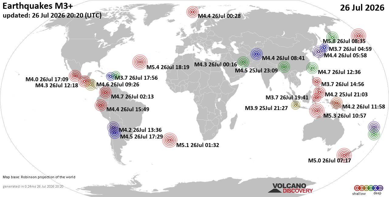
World Earthquake Report for Sunday, 26 July 2026
• Moderate mag. 4.5 earthquake - Estado de Veracruz-Llave, Mexico, on 2026-07...
• Volcano earthquake report for Sunday, 26 Jul 2026
• Moderate mag. 4.0 earthquake - Kabupaten Kepulauan Talaud, 148 km northeast...
• Light mag. 3.9 earthquake - North Pacific Ocean, 65 km south of Puerto San ...
• Strong mag. 5.4 earthquake - Northern Mid-Atlantic Ridge on Sunday, Jul 26,...
|

#814565
Mon 01 Jun 2026 03:55:AM
|
Joined: Feb 2001
Posts: 678,976
Launch Director
|
OP

Launch Director
Joined: Feb 2001
Posts: 678,976 |
SPC MD 927MD 0927 CONCERNING SEVERE THUNDERSTORM WATCH 257... FOR FAR SOUTHEAST SOUTH DAKOTA INTO ADJACENT PORTIONS OF NEBRASKA AND IOWA 
Mesoscale Discussion 0927
NWS Storm Prediction Center Norman OK
0915 PM CDT Sun May 31 2026

Areas affected...Far southeast South Dakota into adjacent portions
of Nebraska and Iowa

Concerning...Severe Thunderstorm Watch 257...

Valid 010215Z - 010415Z

The severe weather threat for Severe Thunderstorm Watch 257
continues.

SUMMARY...A localized corridor of higher tornado potential may
persist for the next couple of hours across far southeast South
Dakota into adjacent portions of Iowa and Nebraska.

DISCUSSION...Additional tornadic supercells have emerged immediately
west of the Sioux Falls, SD and the I-29 corridor based on radar
imagery from KFSD. Near-storm 0-1 km SRH sampled by the local VWP
has recently increased to around 200 m2/s2 immediately ahead of the
approaching storms. Consequently, the near-storm environment is more
favorable for tornadoes than previously anticipated, though storm
interactions appear to be modulating the duration of the tornado
threat to some degree. Additional supercell development is noted on
the southern flank of the emerging cluster, and is already showing
signs of an organizing low-level mesocyclone. It appears likely that
some tornado threat will likely continue for the next 1-2 hours -
most likely on the southern flank of the cluster as it migrates
east/southeast into far northeast NE/northwest IA. Based on the
near-storm environment and observed velocity signatures, a strong
tornado appears possible.

..Moore.. 06/01/2026

...Please see www.spc.noaa.gov for graphic product...

ATTN...WFO...FSD...OAX...

LAT...LON   42589728 43109709 43329697 43359662 43289611 43139602
            42919595 42689607 42519629 42459661 42489704 42589728

MOST PROBABLE PEAK TORNADO INTENSITY...100-125 MPH
MOST PROBABLE PEAK WIND GUST...55-70 MPH
MOST PROBABLE PEAK HAIL SIZE...1.00-1.75 IN
Read morehttps://www.spc.noaa.gov/products/md/md0927.html
|
|



CMS The Best Conveyancing solicitors conveyancing quotes throughout the UK
For any webhosting enquiries please email webmaster@aus-city.com
|
|
Entire Thread
|
 SPC MD 927
|
Webmaster
|
Mon 01 Jun 2026 03:55:AM
|
|
Forums60
Topics793,270
Posts828,053
Members2,960
| |
Most Online102,106
Jul 10th, 2026
|
|
|