|
|
|
0 members (),
1,201
guests, and
21
robots. |
|
Key:
Admin,
Global Mod,
Mod
|
|
S |
M |
T |
W |
T |
F |
S |
|
|
1
|
2
|
3
|
4
|
5
|
6
|
|
7
|
8
|
9
|
10
|
11
|
12
|
13
|
|
14
|
15
|
16
|
17
|
18
|
19
|
20
|
|
21
|
22
|
23
|
24
|
25
|
26
|
27
|
|
28
|
29
|
30
|
|
|
|
|
|
There are no members with birthdays on this day. |

Volcano earthquake report for Thursday, 11 Jun 2026
• Moderate mag. 4.6 earthquake - South Pacific Ocean, Bay of Plenty, 354 km n...
• Moderate magnitude 4.9 earthquake 92 km southwest of Bima, Indonesia
• Moderate mag. 4.4 earthquake - Indian Ocean, 84 km south of Dompu, Indonesi...
• Strong mag. 5.5 earthquake - Philippine Sea, 144 km north of Sangihe Besar ...
• World Earthquake Report for Wednesday, 10 June 2026
|
|
|
Joined: Feb 2001
Posts: 678,976
Launch Director
|
OP

Launch Director
Joined: Feb 2001
Posts: 678,976 |
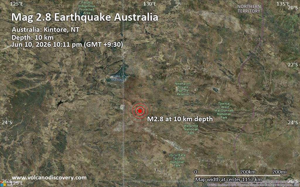
Small magnitude 2.8 earthquake 27 miles southeast of Kintore, Northern Territory, AustraliaJust 15 minutes ago, a 2.8-magnitude earthquake struck near Kintore, MacDonnell, Northern Territory, Australia. The tremor was recorded in the evening on Wednesday, June 10th, 2026, at 9:41 pm local time, at a shallow depth of 6.2 miles below the surface.
The event was filed by Geoscience Australia (GeoAu), the first seismological agency to report it.
A second report was later issued by the citizen-seismograph network of RaspberryShake, which listed it as a magnitude 2.8 earthquake as well. A third agency, the European-Mediterranean Seismological Centre (EMSC), reported the same quake at magnitude 2.8.
According to preliminary calculations, we do not expect that the quake was felt by many people and did not cause any damage. In Kintore (pop. 410, 27 miles away), the quake was probably not felt.
Earthquake data: Date & time: Jun 10, 2026 10:11 pm (GMT +9:30) local time (10 Jun 2026 12:41 GMT)Magnitude: 2.8 Depth: 10.00 km Epicenter latitude / longitude: 23.6°S / 129.63°E  ( MacDonnell, Northern Territory, Australia) Primary data source: GeoAuhttps://www.volcanodiscovery.com/earthquake/news/305115/Small-magnitude-28-earthquake-27-miles-southeast-of-Kintore-Northern-Territory-Australia.html
|
|


CMS The Best Conveyancing solicitors conveyancing quotes throughout the UK
For any webhosting enquiries please email webmaster@aus-city.com
|
|
Entire Thread
|

 Small magnitude 2.8 earthquake 27 miles southeast of Kintore, Northern Territory, Australia
|
Webmaster
|
Yesterday at 12:58 PM
|
|
Forums60
Topics780,535
Posts815,293
Members2,960
| |
Most Online22,463
May 9th, 2026
|
|
|
|
|
Copyright 1996 - 2026 by David Cottle. Designed by David Bate Jr. All Rights Reserved.
By using this forum, the user agrees not to transfer any data or technical information received under this agreement to any other entity without the express approval of the AUS-CITY Forum Admins and/or authors of individual posts (Forum Admins and DoD/USSPACECOM for the analysis of satellite tracking data).
Two-line elements (TLE) and all other satellite data presented and distributed via this forum and AUS-CITY mailing lists are distributed with permission from DoD/USSTRATCOM.

|

|


 - Click image for larger picture.")


