|
|
|
0 members (),
3,867
guests, and
21
robots. |
|
Key:
Admin,
Global Mod,
Mod
|
|
S |
M |
T |
W |
T |
F |
S |
|
|
|
|
1
|
2
|
3
|
4
|
|
5
|
6
|
7
|
8
|
9
|
10
|
11
|
|
12
|
13
|
14
|
15
|
16
|
17
|
18
|
|
19
|
20
|
21
|
22
|
23
|
24
|
25
|
|
26
|
27
|
28
|
29
|
30
|
31
|
|
|
There are no members with birthdays on this day. |

Volcano earthquake report for Friday, 10 Jul 2026
• Moderate mag. 4.2 earthquake - 133 km northwest of Ternate, Kota Ternate, N...
• World Earthquake Report for Friday, 10 July 2026
• Moderate mag. 4.6 earthquake - 17 km southwest of Comalapa, Estado de Chiap...
• Moderate mag. 4.1 earthquake - Olyutorskiy Rayon, 47 km northwest of Tilich...
• Moderate mag. 4.0 earthquake - Hawke's Bay, New Zealand, on Saturday, Jul 1...
|

#820981
Fri 26 Jun 2026 11:43:AM
|
Joined: Feb 2001
Posts: 678,976
Launch Director
|
OP

Launch Director
Joined: Feb 2001
Posts: 678,976 |
Significant magnitude 6.7 earthquake 75 km south of Malapatan, Philippines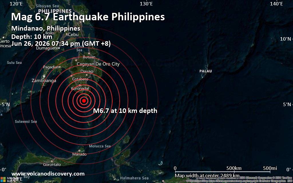 A shallow magnitude 6.7 earthquake was reported early evening near Malapatan, Province of Sarangani, Soccsksargen, Philippines.
According to Indonesia's Meteorology, Climatology, and Geophysical Agency, the quake hit on Friday, June 26th, 2026, at 7:34 pm local time at a shallow depth of 10. km. Shallow earthquakes are felt more strongly than deeper ones as they are closer to the surface. The exact magnitude, epicenter, and depth of the quake might be revised within the next few hours or minutes as seismologists review data and refine their calculations, or as other agencies issue their report.
A second report was later issued by France's Réseau National de Surveillance Sismique (RéNaSS), which listed it as a magnitude 5.7 earthquake.
Based on the preliminary seismic data, the quake should have been felt by everybody in the area of the epicenter. In those areas, dangerous ground shaking occurred with the potential to inflict moderate to heavy damage to buildings and other infrastructure.
Towns or cities where the quake likely caused strong ground shaking include
Moderate shaking probably occurred in Glan (pop. 24,300) located 58 km from the epicenter, Sapu Padidu (pop. 9,800) 69 km away, Sapu Padidu (pop. 9,800) 69 km away, Malapatan (pop. 82,600) 75 km away, Alabel (pop. 90,100) 90 km away, and General Santos (pop. 722,100) 90 km away.
In Malita (pop. 118,400) located 133 km from the epicenter, the quake should have been felt as light shaking.
VolcanoDiscovery will automatically update magnitude and depth if these change and follow up if other significant news about the quake become available. If you’re in the area, please send us your experience through our reporting mechanism, either online or via our mobile app. This will help us provide more first-hand updates to anyone around the globe who wants to know more about this quake.
Earthquake data: Date & time: Jun 26, 2026 07:34 pm (GMT +8) local time (26 Jun 2026 11:34 GMT)Magnitude: 6.7 Depth: 10.00 km Epicenter latitude / longitude: 5.3°N / 125.19°E  (Davao Occidental, Davao, Philippines) Primary data source: BMKGhttps://www.volcanodiscovery.com/earthquake/news/317787/Significant-magnitude-67-earthquake-75-km-south-of-Malapatan-Philippines.html
|
|


CMS The Best Conveyancing solicitors conveyancing quotes throughout the UK
For any webhosting enquiries please email webmaster@aus-city.com
|
|
Entire Thread
|
 Significant magnitude 6.7 earthquake 75 km south of Malapatan, Philippines
|
Webmaster
|
Fri 26 Jun 2026 11:43:AM
|
|
Forums60
Topics789,850
Posts824,628
Members2,960
| |
Most Online102,106
Jul 10th, 2026
|
|
|
|
|
Copyright 1996 - 2026 by David Cottle. Designed by David Bate Jr. All Rights Reserved.
By using this forum, the user agrees not to transfer any data or technical information received under this agreement to any other entity without the express approval of the AUS-CITY Forum Admins and/or authors of individual posts (Forum Admins and DoD/USSPACECOM for the analysis of satellite tracking data).
Two-line elements (TLE) and all other satellite data presented and distributed via this forum and AUS-CITY mailing lists are distributed with permission from DoD/USSTRATCOM.

|

|


 - Click image for larger picture.")


