|
|
|
0 members (),
1,582
guests, and
22
robots. |
|
Key:
Admin,
Global Mod,
Mod
|
|
S |
M |
T |
W |
T |
F |
S |
|
|
|
|
1
|
2
|
3
|
4
|
|
5
|
6
|
7
|
8
|
9
|
10
|
11
|
|
12
|
13
|
14
|
15
|
16
|
17
|
18
|
|
19
|
20
|
21
|
22
|
23
|
24
|
25
|
|
26
|
27
|
28
|
29
|
30
|
31
|
|
|
There are no members with birthdays on this day. |

World Earthquake Report for Sunday, 26 July 2026
• Moderate mag. 4.5 earthquake - Estado de Veracruz-Llave, Mexico, on 2026-07...
• Volcano earthquake report for Sunday, 26 Jul 2026
• Moderate mag. 4.0 earthquake - Kabupaten Kepulauan Talaud, 148 km northeast...
• Light mag. 3.9 earthquake - North Pacific Ocean, 65 km south of Puerto San ...
• Strong mag. 5.4 earthquake - Northern Mid-Atlantic Ridge on Sunday, Jul 26,...
|

#822696
Thu 02 Jul 2026 04:50:PM
|
Joined: Feb 2001
Posts: 678,976
Launch Director
|
OP

Launch Director
Joined: Feb 2001
Posts: 678,976 |
Volcano earthquake report for Thursday, 2 Jul 2026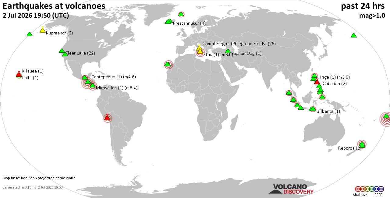 World map showing volcanoes with shallow (less than 50 km) earthquakes within 20 km radius during the past 24 hours on 2 Jul 2026 Number in brackets indicate nr of quakes. Quakes detected near: Auckland Field (1 quake mag 3.0), Balut (17 quakes between mag 1.3-3.6), Cabalian (2 quakes between mag 1.9-1.9), Camiguin de Babuyanes (1 quake mag 2.8), Campi Flegrei (Phlegrean Fields) (26 quakes between mag 0.1-1.8), Chaîne des Puys (2 quakes between mag 1.0-1.4)
Clear Lake (22 quakes between mag 0.2-1.3), Coatepeque (1 quake mag 4.6), Coso (5 quakes between mag 0.9-1.4), El Chichón (1 quake mag 2.8), Eldey (3 quakes between mag 0.3-1.1), Etna (1 quake mag 3.0), Gareloi (10 quakes between mag 0.4-1.8), Geureudong (1 quake mag 2.0), Gilbanta (1 quake mag 2.4), Gran Canaria (1 quake mag 3.0), Iriga (1 quake mag 3.0), Jan Mayen (4 quakes between mag 1.0-2.6), Katla (4 quakes between mag 0.4-1.5), Kilauea (1 quake mag 1.9), Krísuvík (4 quakes between mag 0.2-1.1), Kupreanof (3 quakes between mag 1.2-1.6), Leonard Range (1 quake mag 1.8), Loihi (1 quake mag 2.2), Mayon (2 quakes between mag 2.9-3.2), Prestahnukur (3 quakes between mag 1.2-1.8), Reporoa (1 quake mag 1.4), Sabancaya (1 quake mag 3.5), Santo Tomas (1 quake mag 3.0), Süphan Dağ (1 quake mag 1.4), Talang (1 quake mag 2.4), Tambora (1 quake mag 2.3), Tana (2 quakes between mag 1.7-1.8), Tenerife (7 quakes between mag 1.1-1.9), Todoko-Ranu (1 quake mag 2.9), Upolu (1 quake mag 5.5), Vulcano (1 quake mag 1.9), White Island (1 quake mag 2.2) (updated 16h50)
Note: Earthquakes within 20 km from and at depths less than 50 km under active volcanoes are reported. The list is not complete because many volcanoes are not monitored and/or seismic data in high resolution is not available publicly.
Volcanoes with recent earthquakes above magnitude 2 or more than 10 quakes are listed below:
Auckland Field volcano (North Island): magnitude 3.0 earthquakeA magnitude 3.0 earthquake occurred at the volcano 7 hours ago. The quake, which might be volcanic in origin, was located at a depth of 10.00 km depth at 18 km distance W from the volcano. Earthquake details: Reported seismic-like event (likely no quake): 11 km southwest of Auckland, Auckland, New Zealand, Jul 2, 2026 09:35 pm (GMT +12) (18 km W) All earthquakes at Auckland FieldBalut volcano (Mindanao): 17 earthquakes up to magnitude 3.6Possible earthquake swarm: 17 earthquakes occurred near (under) the volcano during 22 hours, the last being recorded quake 24 minutes ago. Hypocenter depths ranged between 34.00 and 7.00 km. Earthquake details: (only 5 largest) 3.6 quake Philippine Sea, 9.6 km south of Sarangani Island, Philippines, Jul 2, 2026 03:47 pm (GMT +8) (9 km ESE) 2.6 quake Celebes Sea, 20 km west of Sarangani Island, Philippines, Jul 2, 2026 08:18 pm (GMT +8) (8 km W) 2.5 quake Philippine Sea, 8.1 km north of Sarangani Island, Philippines, Jul 2, 2026 12:10 pm (GMT +8) (15 km NE) 2.4 quake Celebes Sea, 20 km west of Sarangani Island, Philippines, Jul 3, 2026 12:26 am (GMT +8) (9 km WNW) 2.4 quake Celebes Sea, 26 km west of Sarangani Island, Philippines, Jul 2, 2026 05:39 pm (GMT +8) (16 km WNW) All earthquakes at BalutCamiguin de Babuyanes volcano (North of Luzon): magnitude 2.8 earthquakeA magnitude 2.8 earthquake occurred at the volcano 19 hours ago. The quake, which might be volcanic in origin, was located at a depth of 10.00 km depth at 19 km distance NE from the volcano. Earthquake details: 2.8 quake 76 km northeast of Aparri, Province of Cagayan, Cagayan Valley, Philippines, Jul 2, 2026 05:46 am (GMT +8) (19 km NE) All earthquakes at Camiguin de BabuyanesCampi Flegrei (Phlegrean Fields) volcano (Italy): 26 earthquakes up to magnitude 1.8Possible earthquake swarm: 26 earthquakes occurred near (under) the volcano during 14 hours, the last being recorded quake 8 hours ago. Hypocenter depths ranged between 2.91 and 0.97 km. Earthquake details: (only 5 largest) 1.8 quake 3.6 km southeast of Pozzuoli, Napoli, Campania, Italy, Jul 2, 2026 12:34 am (GMT +2) (4 km NW) 1.3 quake 3.6 km southeast of Pozzuoli, Napoli, Campania, Italy, Jul 2, 2026 12:46 am (GMT +2) (1 km NW) 1.3 quake 3.4 km southeast of Pozzuoli, Napoli, Campania, Italy, Jul 2, 2026 12:43 am (GMT +2) (1 km WNW) 1.2 quake 3.3 km southeast of Pozzuoli, Napoli, Campania, Italy, Jul 2, 2026 12:52 am (GMT +2) (1 km WNW) 1.0 quake 3 km southeast of Pozzuoli, Napoli, Campania, Italy, Jul 2, 2026 12:28 am (GMT +2) (1 km WNW) All earthquakes at Campi Flegrei (Phlegrean Fields)Clear Lake volcano (California): 22 earthquakes up to magnitude 1.3Possible earthquake swarm: 22 earthquakes occurred near (under) the volcano during 23 hours, the last being recorded quake 1 hour 8 minutes ago. Hypocenter depths ranged between 3.86 and 1.14 km. Earthquake details: (only 5 largest) 1.3 quake Lake County, 28 mi north of Santa Rosa, Sonoma County, California, United States, Jul 1, 2026 11:50 am (GMT -7) (15 km S) 1.2 quake 26 mi north of Santa Rosa, Sonoma County, California, United States, Jul 1, 2026 11:21 am (GMT -7) (18 km SSW) 1.1 quake 26 mi north of Santa Rosa, Sonoma County, California, United States, Jul 2, 2026 08:41 am (GMT -7) (19 km SSW) 1.1 quake 26 mi north of Santa Rosa, Sonoma County, California, United States, Jul 2, 2026 12:02 am (GMT -7) (18 km S) 1.1 quake Lake County, 28 mi north of Santa Rosa, Sonoma County, California, United States, Jul 2, 2026 05:14 am (GMT -7) (15 km S) All earthquakes at Clear LakeCoatepeque volcano (El Salvador): magnitude 4.6 earthquakeA magnitude 4.6 earthquake occurred at the volcano 6 hours ago. The quake, which might be volcanic in origin, was located at a depth of 17.00 km depth at 12 km distance SW from the volcano. Earthquake details: 4.6 quake North Pacific Ocean, 100 km southeast of Puerto San Jose, Guatemala, Jul 2, 2026 04:27 am (GMT -6) (12 km SW) All earthquakes at CoatepequeEl Chichón volcano (Southern Mexico): magnitude 2.8 earthquakeA magnitude 2.8 earthquake occurred at the volcano 19 hours ago. The quake, which might be volcanic in origin, was located at a depth of 3.00 km depth at 2 km distance ESE from the volcano. Earthquake details: 2.8 quake Estado de Chiapas, 36 km southwest of Teapa, Estado de Tabasco, Mexico, Jul 1, 2026 04:11 pm (Mexico_City time) (2 km ESE) All earthquakes at El ChichónEtna volcano (Italy): magnitude 3.0 earthquakeA magnitude 3.0 earthquake occurred at the volcano 21 hours ago. The quake, which might be volcanic in origin, was located at a depth of 10.00 km depth at 0 km distance SW from the volcano. Earthquake details: Reported seismic-like event (likely no quake): 30 km north of Catania, Catania, Sicily, Italy, Jul 1, 2026 10:11 pm (GMT +2) (0 km SW) All earthquakes at EtnaGilbanta volcano (Lesser Sunda Islands): magnitude 2.4 earthquakeA magnitude 2.4 earthquake occurred at the volcano 4 hours ago. The quake, which might be volcanic in origin, was located at a depth of 11.00 km depth at 19 km distance W from the volcano. Earthquake details: 2.4 quake Selat Sumba, 16 km west of Gili Banta Island, West Nusa Tenggara, Indonesia, Jul 2, 2026 09:03 pm (GMT +8) (19 km W) All earthquakes at GilbantaGran Canaria volcano (Canary Islands): magnitude 3.0 earthquakeA magnitude 3.0 earthquake occurred at the volcano 9 hours ago. The quake, which might be volcanic in origin, was located at a depth of 10.00 km depth at 19 km distance ESE from the volcano. Earthquake details: Reported seismic-like event (likely no quake): 13 km south of Las Palmas de Gran Canaria, Las Palmas, Canary Islands, Spain, Jul 2, 2026 09:16 am (GMT +1) (19 km ESE) All earthquakes at Gran CanariaIriga volcano (Luzon Island): magnitude 3.0 earthquakeA magnitude 3.0 earthquake occurred at the volcano 8 hours ago. The quake, which might be volcanic in origin, was located at a depth of 10.00 km depth at 12 km distance WSW from the volcano. Earthquake details: Reported seismic-like event (likely no quake): 31 km southeast of Naga, Province of Camarines Sur, Bicol, Philippines, Jul 2, 2026 04:57 pm (GMT +8) (12 km WSW) All earthquakes at IrigaJan Mayen volcano (Atlantic Ocean): 4 earthquakes up to magnitude 2.64 earthquakes occurred near (under) the volcano during 5 hours, the last being recorded quake 12 hours ago. Hypocenter depths ranged between 0 and 0.00 km. Earthquake details: 2.6 quake 36 km northeast of Olonkinbyen, Jan Mayen, Svalbard and Jan Mayen, Jul 2, 2026 07:03 am (GMT +2) (9 km NE) 1.5 quake Norwegian Sea, 27 km northeast of Jan Mayen Island, Svalbard and Jan Mayen, Jul 2, 2026 05:00 am (GMT +2) (12 km ENE) 1.5 quake Norwegian Sea, 30 km east of Jan Mayen Island, Jan Mayen, Svalbard and Jan Mayen, Jul 2, 2026 04:09 am (GMT +2) (18 km ESE) 1.0 quake Norwegian Sea, 26 km east of Jan Mayen Island, Jan Mayen, Svalbard and Jan Mayen, Jul 2, 2026 02:08 am (GMT +2) (17 km SE) All earthquakes at Jan MayenLoihi volcano (Hawai'i (Big Island)): magnitude 2.2 earthquakeA magnitude 2.2 earthquake occurred at the volcano 19 hours ago. The quake, which might be volcanic in origin, was located at a depth of 38.03 km depth at 17 km distance WNW from the volcano. Earthquake details: 2.2 quake North Pacific Ocean, 15 mi east of Discovery Harbor, Hawaii County, Hawaii, United States, Jul 1, 2026 11:35 am (GMT -10) (17 km WNW) All earthquakes at LoihiMayon volcano (Luzon Island): 2 earthquakes up to magnitude 3.22 earthquakes occurred near (under) the volcano during 9 minutes, the last being recorded quake 11 hours ago. Hypocenter depths ranged between 11.00 and 10.00 km. Earthquake details: 3.2 quake 15 km northeast of Legaspi, Province of Albay, Bicol, Philippines, Jul 2, 2026 01:22 pm (GMT +8) (16 km E) 2.9 quake 14 km northeast of Legaspi, Province of Albay, Bicol, Philippines, Jul 2, 2026 01:14 pm (GMT +8) (15 km E) All earthquakes at MayonSabancaya volcano (Peru): magnitude 3.5 earthquakeA magnitude 3.5 earthquake occurred at the volcano 16 hours ago. The quake, which might be volcanic in origin, was located at a depth of 14.00 km depth at 8 km distance ESE from the volcano. Earthquake details: 3.5 quake 69 km northwest of Selva Alegre, Arequipa, Peru, Jul 1, 2026 08:19 pm (GMT -5) (8 km ESE) All earthquakes at SabancayaSanto Tomas volcano (Luzon Island): magnitude 3.0 earthquakeA magnitude 3.0 earthquake occurred at the volcano 5 hours ago. The quake, which might be volcanic in origin, was located at a depth of 10.00 km depth at 8 km distance NE from the volcano. Earthquake details: Reported seismic-like event (likely no quake): 3.5 km south of Baguio, Philippines, Jul 2, 2026 08:07 pm (GMT +8) (8 km NE) All earthquakes at Santo TomasTalang volcano (Sumatra): magnitude 2.4 earthquakeA magnitude 2.4 earthquake occurred at the volcano 15 hours ago. The quake, which might be volcanic in origin, was located at a depth of 23.00 km depth at 10 km distance NE from the volcano. Earthquake details: 2.4 quake Kabupaten Solok, 15 km southeast of Solok, Indonesia, Jul 2, 2026 09:06 am (GMT +7) (10 km NE) All earthquakes at TalangTambora volcano (Sumbawa): magnitude 2.3 earthquakeA magnitude 2.3 earthquake occurred at the volcano 12 hours ago. The quake, which might be volcanic in origin, was located at a depth of 36.00 km depth at 19 km distance NE from the volcano. Earthquake details: 2.3 quake Kabupaten Bima, 57 km northwest of Dompu, Indonesia, Jul 2, 2026 12:25 pm (GMT +8) (19 km NE) All earthquakes at TamboraTodoko-Ranu volcano (Halmahera): magnitude 2.9 earthquakeA magnitude 2.9 earthquake occurred at the volcano 12 hours ago. The quake, which might be volcanic in origin, was located at a depth of 24.00 km depth at 16 km distance E from the volcano. Earthquake details: 2.9 quake Kabupaten Halmahera Barat, 57 km northeast of Ternate, Indonesia, Jul 2, 2026 02:18 pm (GMT +9) (16 km E) All earthquakes at Todoko-Ranu Upolu volcano (Samoan and Wallis Islands): magnitude 5.5 earthquakeA magnitude 5.5 earthquake occurred at the volcano 20 hours ago. The quake, which might be volcanic in origin, was located at a depth of 10.00 km depth at 12 km distance SSE from the volcano. Earthquake details: 5.5 quake South Pacific Ocean, 248 km south of Pago Pago, Eastern District, American Samoa, Jul 1, 2026 10:12 am (GMT -11) (12 km SSE) All earthquakes at UpoluWhite Island volcano (New Zealand): magnitude 2.2 earthquakeA magnitude 2.2 earthquake occurred at the volcano 23 hours ago. The quake, which might be volcanic in origin, was located at a depth of 2.00 km depth at 18 km distance S from the volcano. Earthquake details: 2.2 quake South Pacific Ocean, 36 km northeast of Whakatane, Bay of Plenty, New Zealand, Jul 2, 2026 06:01 am (GMT +12) (18 km S) All earthquakes at White Islandhttps://www.volcanodiscovery.com/earthquakes-volcanoes/news/318212/Volcano-earthquake-report-for-Thursday-2-Jul-2026.html
|
|


CMS The Best Conveyancing solicitors conveyancing quotes throughout the UK
For any webhosting enquiries please email webmaster@aus-city.com
|
|
Entire Thread
|
 Volcano earthquake report for Thursday, 2 Jul 2026
|
Webmaster
|
Thu 02 Jul 2026 04:50:PM
|
|
Forums60
Topics792,985
Posts827,767
Members2,960
| |
Most Online102,106
Jul 10th, 2026
|
|
|
|
|
Copyright 1996 - 2026 by David Cottle. Designed by David Bate Jr. All Rights Reserved.
By using this forum, the user agrees not to transfer any data or technical information received under this agreement to any other entity without the express approval of the AUS-CITY Forum Admins and/or authors of individual posts (Forum Admins and DoD/USSPACECOM for the analysis of satellite tracking data).
Two-line elements (TLE) and all other satellite data presented and distributed via this forum and AUS-CITY mailing lists are distributed with permission from DoD/USSTRATCOM.

|

|


 - Click image for larger picture.")


