|
0 members (),
2,211
guests, and
22
robots. |
|
Key:
Admin,
Global Mod,
Mod
|
|
S |
M |
T |
W |
T |
F |
S |
|
|
|
|
|
|
|
1
|
|
2
|
3
|
4
|
5
|
6
|
7
|
8
|
|
9
|
10
|
11
|
12
|
13
|
14
|
15
|
|
16
|
17
|
18
|
19
|
20
|
21
|
22
|
|
23
|
24
|
25
|
26
|
27
|
28
|
29
|
|
30
|
31
|
|
|
|
|
|
|
There are no members with birthdays on this day. |
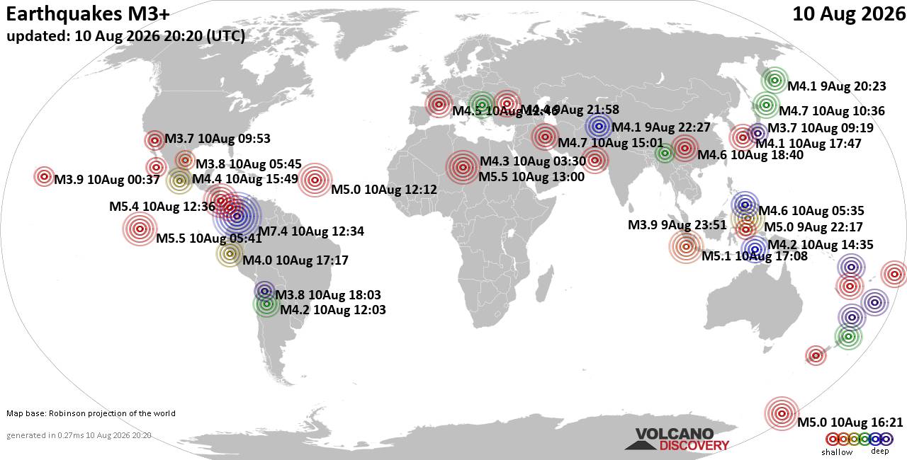
World Earthquake Report for Monday, 10 August 2026
• Volcano earthquake report for Monday, 10 Aug 2026
• Moderate mag. 4.0 earthquake - Zangilan Rayon, 58 km southwest of Ganja, Ga...
• Moderate mag. 4.6 earthquake - 31 km northeast of Xunchang, Sichuan, China,...
• Moderate mag. 4.2 earthquake - New Zealand on Tuesday, Aug 11, 2026, at 06:...
• World Earthquake Report for August 2026
|
|
|
Joined: Feb 2001
Posts: 678,976
Launch Director
|
OP

Launch Director
Joined: Feb 2001
Posts: 678,976 |
SPC MD 1907MD 1907 CONCERNING SEVERE POTENTIAL...WATCH LIKELY FOR WESTERN SOUTH DAKOTA INTO NORTH-CENTRAL NEBRASKA 
Mesoscale Discussion 1907
NWS Storm Prediction Center Norman OK
0539 PM CDT Mon Aug 10 2026

Areas affected...Western South Dakota into north-central Nebraska

Concerning...Severe potential...Watch likely

Valid 102239Z - 110045Z

Probability of Watch Issuance...80 percent

SUMMARY...Thunderstorms developing across western South Dakota may
intensify into a robust MCS in the coming hours. If/when this
occurs, the potential for severe winds will substantially increase
downstream into southern South Dakota and north-central Nebraska.
Watch issuance is probable if convection intensifies as expected.

DISCUSSION...Large-scale ascent continues to spread east across the
central and northern High Plains based on recent GOES imagery with
several clusters of high-based thunderstorms emerging from eastern
MT into eastern WY and CO. More recently, a cluster of high-based
thunderstorms has developed across far western SD in proximity to
the western fringe of a moist plume that extends from the central
Plains into western SD around a weak surface low analyzed south of
the Black Hills. Over time, this convection should intensify as it
continues to spread east into the moist air mass where MLCAPE
rapidly increases into the 3000-4500 J/kg range.

Additionally, the combination of southeasterly low-level winds to
the north of the low with 30-40 knot mid-level flow aloft is
supporting around 40-50 knots of effective bulk shear across the
warm sector. This will likely promote organization of deepening
convection over the next few hours - most likely into an MCS as cold
pools continue to amalgamate and deepen. If an MCS emerges, the
downstream environment will likely support severe gusts as high as
65-80 mph, and potentially a few embedded circulations given strong
westerly low-level shear.

Most high-res solutions over the past several hours have depicted
some form of an MCS emerging out of the Dakotas this evening, though
considerable spread is noted on precisely when and where such an MCS
will emerge. Based on these observed trends, this cluster may
develop into the anticipated MCS. Trends will continue to be
monitored, and watch issuance will likely be required if the cluster
continues to intensify.

..Moore/Mosier.. 08/10/2026

...Please see www.spc.noaa.gov for graphic product...

ATTN...WFO...FSD...ABR...LBF...UNR...CYS...

LAT...LON   42350100 43390398 43660419 44160422 44430415 44640385
            44700351 44349913 43859875 43259880 42839910 42539963
            42360032 42350100

MOST PROBABLE PEAK TORNADO INTENSITY...UP TO 90 MPH
MOST PROBABLE PEAK WIND GUST...65-80 MPH
MOST PROBABLE PEAK HAIL SIZE...1.50-2.50 IN
Read morehttps://www.spc.noaa.gov/products/md/md1907.html
|
|



CMS The Best Conveyancing solicitors conveyancing quotes throughout the UK
For any webhosting enquiries please email webmaster@aus-city.com
|
|
Entire Thread
|

 SPC MD 1907
|
Webmaster
|
Yesterday at 10:56 PM
|
|
Forums60
Topics795,908
Posts830,698
Members2,960
| |
Most Online102,106
Jul 10th, 2026
|
|
|





































