|
1 members (Alisa),
2,521
guests, and
21
robots. |
|
Key:
Admin,
Global Mod,
Mod
|
|
S |
M |
T |
W |
T |
F |
S |
|
|
|
|
|
1
|
2
|
3
|
|
4
|
5
|
6
|
7
|
8
|
9
|
10
|
|
11
|
12
|
13
|
14
|
15
|
16
|
17
|
|
18
|
19
|
20
|
21
|
22
|
23
|
24
|
|
25
|
26
|
27
|
28
|
29
|
30
|
31
|
|
There are no members with birthdays on this day. |
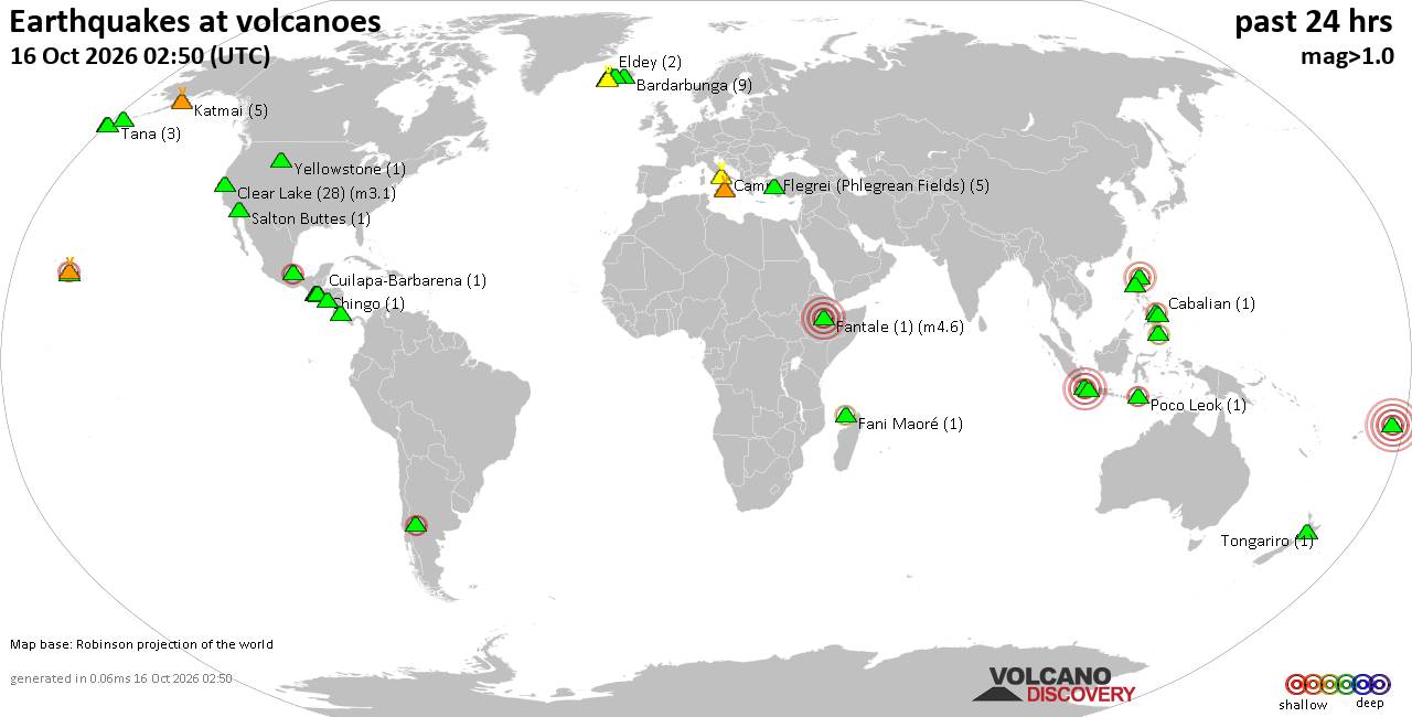
Volcano earthquake report for Friday, 16 October 2026
• M 3.1 - 202 km SE of Atka, Alaska
• M 2.3 - 40 km E of Chase, Alaska
• M 3.6 - 2 km NW of Knik, Alaska
• M 3.3 - 65 km NE of Punta Cana, Dominican Republic
• M 3.6 - 282 km ESE of Chiniak, Alaska
|

#837760
Mon 24 Aug 2026 08:50:AM
|
Joined: Feb 2001
Posts: 678,977
Launch Director
|
|
Launch Director
Joined: Feb 2001
Posts: 678,977 |
Issued at 200 AM PDT Mon Aug 24 2026 000
WTPZ34 KNHC 240850
TCPEP4
BULLETIN
Tropical Storm Iselle Advisory Number 4
NWS National Hurricane Center Miami FL EP092026
200 AM PDT Mon Aug 24 2026
...ISELLE STRENGTHENS SLIGHTLY...
SUMMARY OF 200 AM PDT...0900 UTC...INFORMATION
----------------------------------------------
LOCATION...17.8N 116.2W
ABOUT 540 MI...865 KM SW OF THE SOUTHERN TIP OF BAJA CALIFORNIA
MAXIMUM SUSTAINED WINDS...60 MPH...95 KM/H
PRESENT MOVEMENT...NW OR 315 DEGREES AT 12 MPH...19 KM/H
MINIMUM CENTRAL PRESSURE...996 MB...29.42 INCHES
WATCHES AND WARNINGS
--------------------
There are no coastal watches or warnings in effect.
DISCUSSION AND OUTLOOK
----------------------
At 200 AM PDT (0900 UTC), the center of Tropical Storm Iselle was
located near latitude 17.8 North, longitude 116.2 West. Iselle is
moving toward the northwest near 12 mph (19 km/h) and this motion is
expected to continue through tonight, followed by a gradual turn
toward the west-northwest on Tuesday.
Maximum sustained winds have increased to near 60 mph (95 km/h) with
higher gusts. Some strengthening is expected over the next day or
so, and Iselle could become a short-lived hurricane by late tonight.
Gradual weakening is then forecast starting on Tuesday.
Tropical-storm-force winds extend outward up to 125 miles (205 km)
from the center.
The estimated minimum central pressure is 996 mb (29.42 inches).
HAZARDS AFFECTING LAND
----------------------
SURF: Swells generated by Iselle will affect the west coast of the
Baja California Peninsula beginning today. These swells are likely
to cause life-threatening surf and rip current conditions. Please
consult products from your local weather office.
NEXT ADVISORY
-------------
Next complete advisory at 800 AM PDT.
$$
Forecaster Adams Source: Tropical Storm Iselle Public Advisory Number 4
|
|



CMS The Best Conveyancing solicitors conveyancing quotes throughout the UK
For any webhosting enquiries please email webmaster@aus-city.com
|
|
Entire Thread
|
 Tropical Storm Iselle Public Advisory Number 4
|
Webmaster
|
Mon 24 Aug 2026 08:50:AM
|
|
Forums60
Topics879,145
Posts913,942
Members2,960
| |
Most Online102,106
Jul 10th, 2026
|
|
|









































