|
|
|
0 members (),
1,435
guests, and
23
robots. |
|
Key:
Admin,
Global Mod,
Mod
|
|
S |
M |
T |
W |
T |
F |
S |
|
|
|
|
|
1
|
2
|
3
|
|
4
|
5
|
6
|
7
|
8
|
9
|
10
|
|
11
|
12
|
13
|
14
|
15
|
16
|
17
|
|
18
|
19
|
20
|
21
|
22
|
23
|
24
|
|
25
|
26
|
27
|
28
|
29
|
30
|
31
|
|
There are no members with birthdays on this day. |
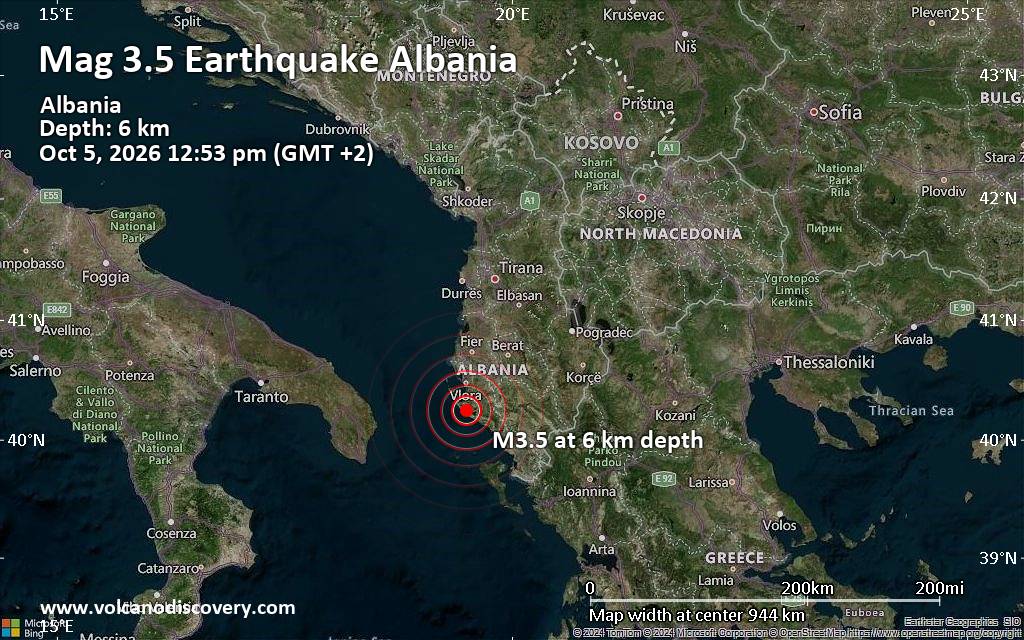
Magnitude 3.5 earthquake strikes near Vlore, Bashkia Vlorë, Qarku i Vlores, Albania
• M 2.1 - 2 km S of Forest Park, Georgia
• M 5.0 - Mariana Islands region
• M 1.2 - 10 km WSW of Shamrock, Oklahoma
• M 3.5 - 137 km NNE of Vieques, Puerto Rico
• M 2.1 - 69 km NE of Chignik, Alaska
• M 5.0 - 187 km ENE of Saipan, Northern Mariana Islands
|

#850068
Thu 27 Aug 2026 07:30:AM
|
Joined: Feb 2001
Posts: 678,977
Launch Director
|
|
Launch Director
Joined: Feb 2001
Posts: 678,977 |
SPC Aug 27, 2026 0730 UTC Day 3 Severe Thunderstorm OutlookSPC 0730Z Day 3 Outlook 
Day 3 Convective Outlook
NWS Storm Prediction Center Norman OK
0228 AM CDT Thu Aug 27 2026

Valid 291200Z - 301200Z

...THERE IS A MARGINAL RISK OF SEVERE THUNDERSTORMS FOR PORTIONS OF
THE NORTHERN GREAT BASIN AND THE NORTHERN PLAINS...

...SUMMARY...
Isolated strong to severe storms are possible in parts of the
northern Great Basin and across the northern Plains.

...Northern Great Basin Vicinity...
A broad range of 00Z guidance (GFS/RRFS/NAM) shows moderate
instability developing across northern Utah on Saturday amid strong
surface heating. Forecast soundings show an uncapped airmass by
mid-afternoon when scattered thunderstorm activity is expected to
begin. 45 to 50 knots of mid-level flow will support storm
organization/longevity and some damaging wind threat (some 75+ mph).
The ECMWF is the least unstable, with more cloud-cover across the
region, which may limit the severe weather threat somewhat.
Nonetheless, even this ECMWF solution would likely support some
severe wind threat. Therefore, a Marginal Risk seems warranted, and
if all guidance trends toward the more unstable solution, an upgrade
to Slight Risk may be needed in later outlooks.

...Northern Plains...
Moderate to strong instability is forecast across the Northern
Plains on Saturday within a moist region to the north of a surface
low. Forcing will be relatively weak, but subtle height falls and
perhaps a weak mid-level shortwave trough embedded within the
southwesterly flow, may be sufficient for isolated to widely
scattered storms Saturday afternoon/evening. Forecast soundings show
long hodographs across the region which would support a supercell
storm mode. A Marginal Risk has been added for this threat, but the
lack of stronger forcing precludes higher probabilities at this
time.

..Bentley.. 08/27/2026
Read morehttps://www.spc.noaa.gov/products/outlook/day3otlk_0730.html
|
|



CMS The Best Conveyancing solicitors conveyancing quotes throughout the UK
For any webhosting enquiries please email webmaster@aus-city.com
|
|
Entire Thread
|
 SPC Aug 27, 2026 0730 UTC Day 3 Severe Thunderstorm Outlook
|
Webmaster
|
Thu 27 Aug 2026 07:30:AM
|
|
Forums60
Topics857,689
Posts892,484
Members2,960
| |
Most Online102,106
Jul 10th, 2026
|
|
|
|
|

|









































