|
1 members (Alisa),
1,791
guests, and
20
robots. |
|
Key:
Admin,
Global Mod,
Mod
|
|
S |
M |
T |
W |
T |
F |
S |
|
|
|
1
|
2
|
3
|
4
|
5
|
|
6
|
7
|
8
|
9
|
10
|
11
|
12
|
|
13
|
14
|
15
|
16
|
17
|
18
|
19
|
|
20
|
21
|
22
|
23
|
24
|
25
|
26
|
|
27
|
28
|
29
|
30
|
|
|
|
|
There are no members with birthdays on this day. |
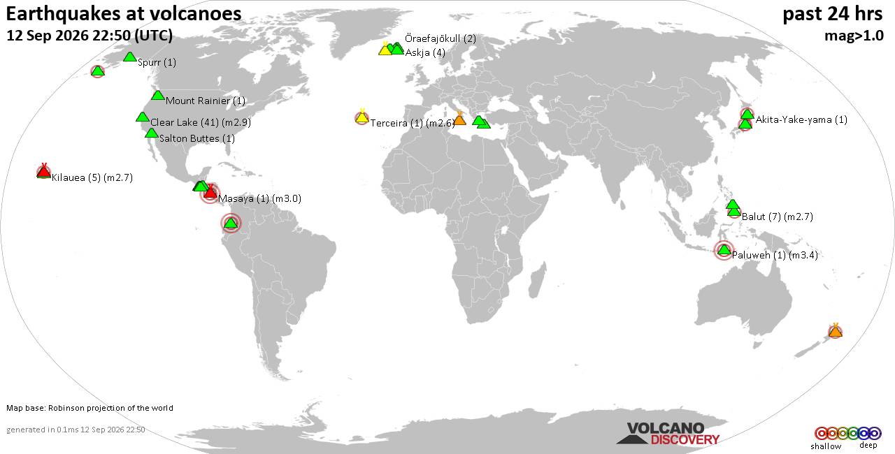
Volcano earthquake report for Saturday, 12 September 2026
• World Earthquake Report for Saturday, 12 September 2026
• Moderate but deep magnitude 5.3 quake hits 74 km southeast of Nakanoshima, ...
• Strong mag. 5.3 earthquake - Ryukyu Islands, Japan, on Sunday, Sep 13, 2026...
• Seismic-like event, possible earthquake, reported minutes ago near Pasto, N...
• Moderate mag. 4.3 earthquake - Philippine Sea, 34 km south of Miyake, Tokyo...
|
|
|
Joined: Feb 2001
Posts: 678,977
Launch Director
|
|
Launch Director
Joined: Feb 2001
Posts: 678,977 |
SPC Day 2 Fire Weather OutlookSPC Day 2 Fire Weather Outlook 
Day 2 Fire Weather Outlook
NWS Storm Prediction Center Norman OK
0240 PM CDT Sat Sep 12 2026

Valid 131200Z - 141200Z

An upper-level low and attendant 70 mid-level jet over the Pacific
Northwest will progress into the Northern Rockies through D2/Sunday.
Dry, southwest wind ahead of a surface cold front augmented by the
robust mid-level flow and efficient daytime boundary layer mixing
will bring elevated fire weather conditions to the southern Great
Basin Sunday. Southwest winds of 15-20 mph and RH reductions of
10-15% will promote an elevated fire weather threat for southern NV
and west-central UT. Farther north, west/southwest post-frontal
winds of around 15 mph (locally 20 mph) are expected across much of
northern NV, including the Sierra Front into southern ID and parts
of southwestern MT. Although cooler, daytime RH is still expected to
fall close to 15% by mid-afternoon within an increasingly dry
post-frontal air mass. Fuels across the Great Basin continue to dry
with ERCs nearing the 80th percentile in some locations.

..Williams.. 09/12/2026

.PREV DISCUSSION... /ISSUED 0203 AM CDT Sat Sep 12 2026/

...Synopsis...
As an upper-level low and associated 70 kt jet streak moves from the
Pacific Northwest into the Northern Rockies on Sunday, dry and gusty
conditions at the surface will support Elevated fire-weather
conditions over much of the Great Basin into the Snake River Valley
and portions of southwestern Montana.

...Great Basin into portions of Idaho and Montana...
Beneath the compact upper-level low and associated strong jet
streak, deep boundary layer mixing will result in broad, gusty
southwest flow of 15-20 MPH and relative humidity around 15%.
Elevated fire-weather conditions could persist as the upper low
progresses eastward and a relatively dry cold front moves across the
region. Fuels guidance has ERCs generally at or below the 70th
annual percentiles, tempering overall fire-weather concerns.

...Please see www.spc.noaa.gov/fire for graphic product...
Read morehttps://www.spc.noaa.gov/products/fire_wx/fwdy2.html
|
|



CMS The Best Conveyancing solicitors conveyancing quotes throughout the UK
For any webhosting enquiries please email webmaster@aus-city.com
|
|
Entire Thread
|

 SPC Day 2 Fire Weather Outlook
|
Webmaster
|
Yesterday at 07:41 PM
|
|
Forums60
Topics825,378
Posts860,171
Members2,960
| |
Most Online102,106
Jul 10th, 2026
|
|
|





































