|
1 members (Alisa),
2,521
guests, and
21
robots. |
|
Key:
Admin,
Global Mod,
Mod
|
|
S |
M |
T |
W |
T |
F |
S |
|
|
|
|
|
1
|
2
|
3
|
|
4
|
5
|
6
|
7
|
8
|
9
|
10
|
|
11
|
12
|
13
|
14
|
15
|
16
|
17
|
|
18
|
19
|
20
|
21
|
22
|
23
|
24
|
|
25
|
26
|
27
|
28
|
29
|
30
|
31
|
|
There are no members with birthdays on this day. |
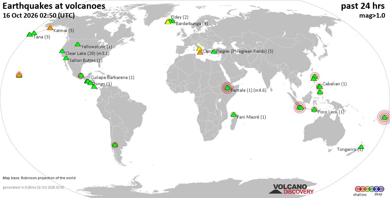
Volcano earthquake report for Friday, 16 October 2026
• M 3.1 - 202 km SE of Atka, Alaska
• M 2.3 - 40 km E of Chase, Alaska
• M 3.6 - 2 km NW of Knik, Alaska
• M 3.3 - 65 km NE of Punta Cana, Dominican Republic
• M 3.6 - 282 km ESE of Chiniak, Alaska
|

#865105
Wed 16 Sep 2026 05:56:AM
|
Joined: Feb 2001
Posts: 678,977
Launch Director
|
|
Launch Director
Joined: Feb 2001
Posts: 678,977 |
SPC Sep 16, 2026 0600 UTC Day 2 Convective OutlookSPC 0600Z Day 2 Outlook 
Day 2 Convective Outlook
NWS Storm Prediction Center Norman OK
1227 AM CDT Wed Sep 16 2026

Valid 171200Z - 181200Z

...NO SEVERE THUNDERSTORM AREAS FORECAST...

...SUMMARY...
The risk for severe thunderstorms appears low across the U.S.
Thursday through Thursday night.

...Discussion...
Within the westerlies, which remain confined to the northern
mid-latitudes, models continue to indicate that consolidating
large-scale mid-level troughing will dig through northern Ontario,
Quebec and adjacent portions of the Northeast through this period.
It appears that this may contribute to some southwestward
suppression of the persistent prominent mid-level ridging initially
centered near or southwest of the Mid South vicinity early Thursday.

In lower levels, it appears that this will be accompanied by a
developing area of surface low pressure, trailed by a reinforcing
cool intrusion across the St. Lawrence Valley, upper Great Lakes and
adjacent Upper Midwest.  A preceding front, advancing to the
south/southeast of the lower Great Lakes, may continue to overtake
the Ohio Valley segment of an initial quasi-stationary frontal zone
and advance through much of the Mid Atlantic and lower Ohio Valley
by 12Z Friday. The quasi-stationary boundary may remain so across
the lower Missouri Valley, but perhaps shift slowly northward across
the central Great Plains in response to a weak short wave
perturbation migrating around the northwestern periphery of the
mid-level ridging.

It appears that this impulse will precede a cut-off low, initially
inland of the northern California coast, before redeveloping
north-northeastward and elongating across the northern Intermountain
region and Great Basin later Thursday through Thursday night.

Along the southeastern periphery of the mid-level ridge, another
perturbation is still forecast to slowly overspread portions of
south Atlantic coastal areas.

...Great Plains through Ohio Valley...
Guidance continues to indicate that seasonably high boundary-layer
moisture content, focused along and south of the initial
quasi-stationary frontal zone, and generally beneath the mid-level
ridging, will again contribute to sizable mixed-layer CAPE with
insolation Thursday.  However, generally warm thermodynamic profiles
and weak deep-layer mean flow/shear probably will continue to
inhibit the risk for organized severe thunderstorm activity.

In association with a low amplitude mid-level wave emerging from the
Four Corners, an increase in thunderstorm development is forecast
overnight, aided by lower/mid-tropospheric warm advection on a
strengthening southerly 850-700 mb jet.  Focused mostly across the
middle Missouri Valley, well to the north of the surface frontal
zone where elevated instability is likely to remain limited, this
activity is expected to remain weak with little risk for severe
weather.

..Kerr.. 09/16/2026
Read morehttps://www.spc.noaa.gov/products/outlook/day2otlk_0600.html
|
|



CMS The Best Conveyancing solicitors conveyancing quotes throughout the UK
For any webhosting enquiries please email webmaster@aus-city.com
|
|
Entire Thread
|
 SPC Sep 16, 2026 0600 UTC Day 2 Convective Outlook
|
Webmaster
|
Wed 16 Sep 2026 05:56:AM
|
|
Forums60
Topics879,145
Posts913,942
Members2,960
| |
Most Online102,106
Jul 10th, 2026
|
|
|









































