|
0 members (),
2,234
guests, and
26
robots. |
|
Key:
Admin,
Global Mod,
Mod
|
|
S |
M |
T |
W |
T |
F |
S |
|
|
|
1
|
2
|
3
|
4
|
5
|
|
6
|
7
|
8
|
9
|
10
|
11
|
12
|
|
13
|
14
|
15
|
16
|
17
|
18
|
19
|
|
20
|
21
|
22
|
23
|
24
|
25
|
26
|
|
27
|
28
|
29
|
30
|
|
|
|
|
There are no members with birthdays on this day. |
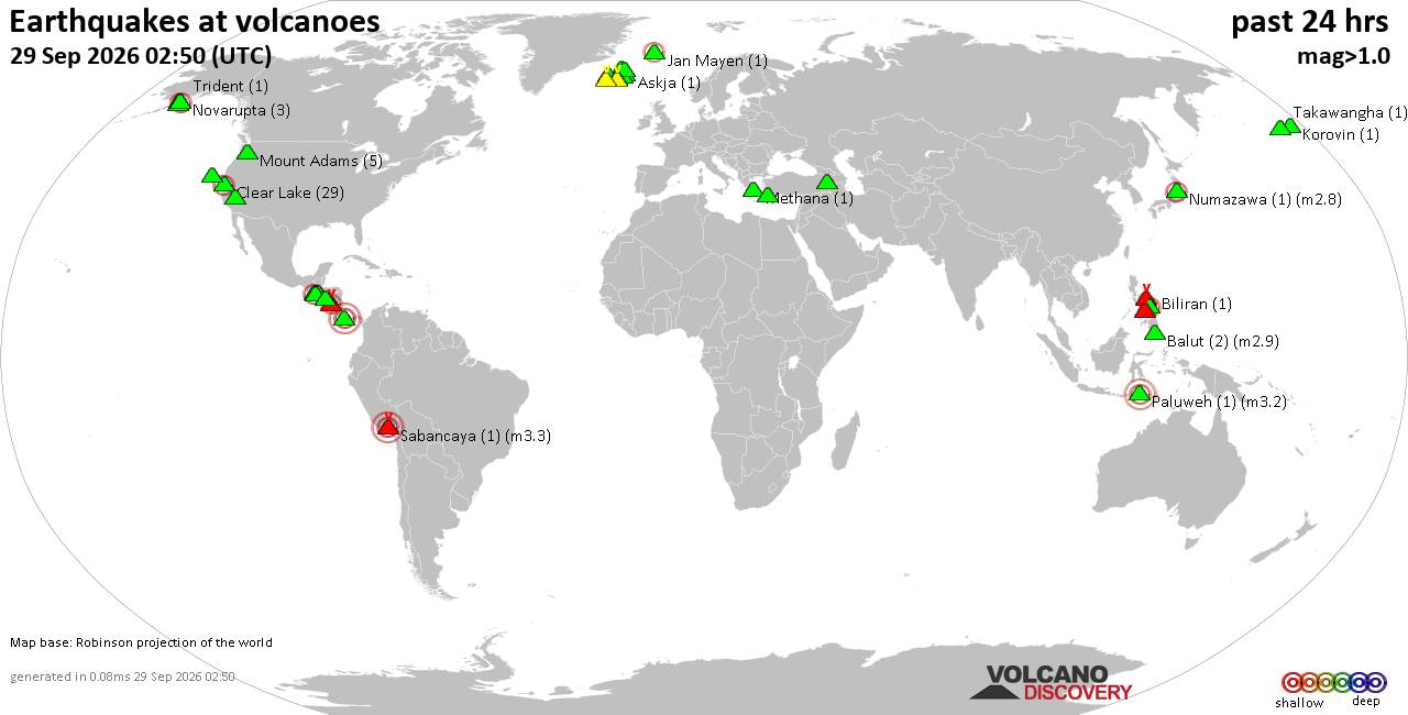
Volcano earthquake report for Tuesday, 29 September 2026
• M 1.0 - 7 km NW of The Geysers, CA
• M 1.8 - 57 km S of Whites City, New Mexico
• M 1.8 - 57 km S of Whites City, New Mexico
• M 2.2 - 8 km W of Cotati, CA
• M 3.5 - 184 km SE of Perryville, Alaska
|
|
|
Joined: Feb 2001
Posts: 678,977
Launch Director
|
|
Launch Director
Joined: Feb 2001
Posts: 678,977 |
SPC Sep 29, 2026 2000 UTC Day 1 Convective OutlookSPC 2000Z Day 1 Outlook 
Day 1 Convective Outlook
NWS Storm Prediction Center Norman OK
0245 PM CDT Tue Sep 29 2026

Valid 292000Z - 301200Z

...THERE IS A MARGINAL RISK OF SEVERE THUNDERSTORMS FROM SOUTHERN
ARIZONA ACROSS SOUTHERN/EASTERN NEW MEXICO INTO WEST TEXAS...

...SUMMARY...
Isolated severe thunderstorm wind gusts and possibly a tornado or
two could occur this afternoon into tonight from southeast Arizona
across southern and eastern New Mexico into west Texas.

...20z Update...
No changes were made to the existing severe probabilities with this
update as the forecast remains generally on track. An increase in
thunderstorm coverage (likely in the form of a complex/linear storm
mode) is expected this afternoon/evening as the remnant core of Polo
progresses northeastward into the southern High Plains. As this
occurs, isolated severe wind gusts and perhaps a tornado or two may
occur, with locally greater potential possible from southeastern New
Mexico into West Texas where less prevalent cloud cover has allowed
for stronger diurnal heating through mid afternoon. See the
discussion below for additional details.

..Chalmers/Thornton.. 09/29/2026

.PREV DISCUSSION... /ISSUED 1120 AM CDT Tue Sep 29 2026/

...Synopsis...
Fairly complex synoptic evolution is anticipated today through
tonight as a remnants of what is currently Hurricane Polo become
absorbed within the circulation of the deepening mid-latitude
cyclone currently centered over the Lower CO River Valley. In
general, the Lower CO River Valley cyclone is forecast to deepen as
it gradually shifts eastward. In response, Hurricane Polo is
forecast to move quickly northeastward across Sonora and into New
Mexico. Polo is forecast to weaken over the mountainous terrain of
northern Mexico, but will likely maintain some of its warm-core
characteristics through at least tomorrow morning. Additionally,
mass response across the southern High Plains will result in
increasing low-level moisture advection across the southern Plains
while also aiding in surface cyclogenesis across central and eastern
NM late tonight/early tomorrow.

...Southern Arizona...
Recent surface analysis reveals a very moist airmass over southern
AZ, with a corridor of mid to upper 60s dewpoints extending from the
central southern border into the Phoenix vicinity. Surface analysis
also places a weak low over south-central AZ. VAD profiles from IWA
and EMX both show fairly long hodographs, supported by 30 to 40 kt
of low/mid-level southwesterly flow. Widespread showers and
thunderstorms will likely continue throughout the day, with limited
diurnal heating and weak tropical lapse rates keeping buoyancy
modest. Even so, the strong nature of the wind profiles could
support a few at least weak/transient supercells, and potentially
more organized convective bands later today, with at least some
potential for strong thunderstorm wind gusts.

...Southern High Plains...
Thunderstorm coverage is expected to increase notably this
afternoon/evening as the core of Polo progresses into the region.
Tropical character of the airmass will keep lapse rates poor while
cloud cover also limits heating, limiting the overall buoyancy.
Nonetheless, buoyant thermodynamic profiles are still expected to
result in updrafts deep enough for lightning production.
Additionally, low-level wind profiles are expected to lengthen
significantly after 00Z as the remnants of Polo interact with a
dynamically strengthening low-level jet. The widespread storm
coverage will result in a tendency toward complex or linear storm
modes with time, though a few/episodic supercells will also be
possible. A brief tornado and/or strong wind gusts could accompany
any organized, more persistent storm structures.
Read morehttps://www.spc.noaa.gov/products/outlook/day1otlk_2000.html
|
|



CMS The Best Conveyancing solicitors conveyancing quotes throughout the UK
For any webhosting enquiries please email webmaster@aus-city.com
|
|
Entire Thread
|

 SPC Sep 29, 2026 2000 UTC Day 1 Convective Outlook
|
Webmaster
|
3 hours ago
|
|
Forums60
Topics847,838
Posts882,633
Members2,960
| |
Most Online102,106
Jul 10th, 2026
|
|
|









































