|
0 members (),
2,464
guests, and
26
robots. |
|
Key:
Admin,
Global Mod,
Mod
|
|
S |
M |
T |
W |
T |
F |
S |
|
|
|
|
|
1
|
2
|
3
|
|
4
|
5
|
6
|
7
|
8
|
9
|
10
|
|
11
|
12
|
13
|
14
|
15
|
16
|
17
|
|
18
|
19
|
20
|
21
|
22
|
23
|
24
|
|
25
|
26
|
27
|
28
|
29
|
30
|
31
|
|
There are no members with birthdays on this day. |
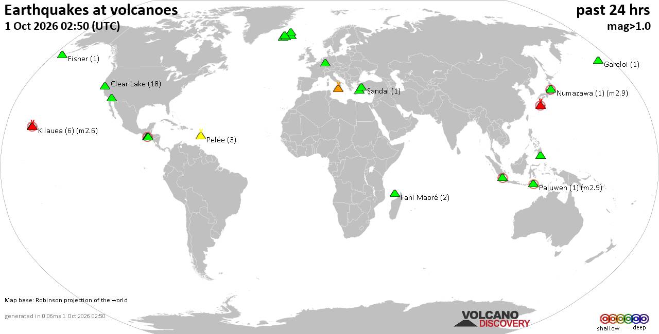
Volcano earthquake report for Thursday, 1 October 2026
• M 2.9 - 171 km WSW of Nikolski, Alaska
• M 1.1 - 29 km NNE of Paxson, Alaska
• M 3.4 - 5 km WSW of Volcano, Hawaii
• M 1.4 - 79 km SSW of Kaktovik, Alaska
• M 1.4 - 123 km WNW of Arctic Village, Alaska
|
|
|
Joined: Feb 2001
Posts: 678,977
Launch Director
|
|
Launch Director
Joined: Feb 2001
Posts: 678,977 |
Issued at 200 AM MST Thu Oct 01 2026 000
WTPZ43 KNHC 010851
TCDEP3
Hurricane Rachel Discussion Number 17
NWS National Hurricane Center Miami FL EP182026
200 AM MST Thu Oct 01 2026
Satellite imagery indicates that Rachel's convective structure has
improved over the past several hours. Deep convection continues to
expand over the center, with cloud-top temperatures as cold as -85
C. The latest subjective Dvorak intensity estimate from TAFB is
T4.5/77 kt, while objective estimates have ranged from 65 to 85 kt.
Given these estimates and the improved convective organization, the
initial intensity is raised to 85 kt.
Rachel continues to move west-northwestward, or 300/5 kt, and this
motion is expected to continue during the next day or so while a
mid- to upper-level trough remains over the southwestern United
States. As the trough lifts northeastward and weakens, a ridge is
forecast to build north of Rachel, causing the system to gradually
turn more toward the west by the weekend. The track guidance remains
in good agreement on this overall scenario, and the latest NHC track
forecast is essentially unchanged from the previous prediction,
lying near the HCCA and GDMI aids.
Environmental conditions should remain generally favorable for
strengthening during the next couple of days, with very warm sea
surface temperatures and plenty of mid-level moisture along the
forecast track. Persistent easterly to northeast vertical wind shear
of around 15 kt may be a limiting factor in the short term, but the
shear is forecast to gradually relax thereafter. Rachel should
continue to strengthen over the next 24 h, especially if the
inner-core structure continues to improve, and is forecast to become
a major hurricane within the next couple of days. Thereafter,
progressively cooler sea surface temperatures and dry mid-level air
should induce a gradual weakening trend. The latest NHC intensity
forecast is similar to the previous advisory, lying above the
guidance envelope in the short term before trending toward the upper
end of the guidance thereafter.
FORECAST POSITIONS AND MAX WINDS
INIT 01/0900Z 19.4N 109.3W 85 KT 100 MPH
12H 01/1800Z 19.6N 109.8W 90 KT 105 MPH
24H 02/0600Z 19.8N 110.4W 100 KT 115 MPH
36H 02/1800Z 19.9N 111.1W 105 KT 120 MPH
48H 03/0600Z 20.2N 112.1W 100 KT 115 MPH
60H 03/1800Z 20.4N 113.2W 95 KT 110 MPH
72H 04/0600Z 20.5N 114.3W 90 KT 105 MPH
96H 05/0600Z 20.6N 116.5W 85 KT 100 MPH
120H 06/0600Z 20.7N 119.4W 80 KT 90 MPH
$$
Forecaster Gibbs Source: Hurricane Rachel Forecast Discussion Number 17
|
|



CMS The Best Conveyancing solicitors conveyancing quotes throughout the UK
For any webhosting enquiries please email webmaster@aus-city.com
|
|
Entire Thread
|

 Hurricane Rachel Forecast Discussion Number 17
|
Webmaster
|
6 hours ago
|
|
Forums60
Topics851,304
Posts886,099
Members2,960
| |
Most Online102,106
Jul 10th, 2026
|
|
|









































