|
0 members (),
1,357
guests, and
25
robots. |
|
Key:
Admin,
Global Mod,
Mod
|
|
S |
M |
T |
W |
T |
F |
S |
|
|
|
|
|
1
|
2
|
3
|
|
4
|
5
|
6
|
7
|
8
|
9
|
10
|
|
11
|
12
|
13
|
14
|
15
|
16
|
17
|
|
18
|
19
|
20
|
21
|
22
|
23
|
24
|
|
25
|
26
|
27
|
28
|
29
|
30
|
31
|
|
There are no members with birthdays on this day. |
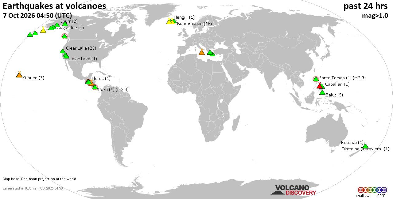
Volcano earthquake report for Wednesday, 7 October 2026
• M 1.3 - 4 km WSW of Guánica, Puerto Rico
• M 0.8 - 9 km SE of Gorman, CA
• M 4.6 - 116 km NE of Hengchun, Taiwan
• M 1.7 - 47 km W of Salamatof, Alaska
• M 1.1 - 38 km NW of Stanton, Texas
• M 1.0 - 5 km NNW of Beaumont, CA
|
|
|
Joined: Feb 2001
Posts: 678,977
Launch Director
|
|
Launch Director
Joined: Feb 2001
Posts: 678,977 |
Issued at 200 AM PDT Wed Oct 07 2026 000
WTPZ43 KNHC 070900
TCDEP3
Hurricane Rachel Discussion Number 41
NWS National Hurricane Center Miami FL EP182026
200 AM PDT Wed Oct 07 2026
Satellite imagery indicates that Rachel's convective organization
has changed little over the past several hours. The deepest
convection remains focused over the southern semicircle, with
limited convection over the northern portion of the cyclone due to
dry air intrusions and modest easterly shear. A 0426 UTC MetOp-B
scatterometer pass helped refine the wind radii and structure of the
cyclone. Based on these data and the largely unchanged satellite
presentation, the initial intensity is held at 70 kt.
The initial motion continues westward, or 275/6 kt. Rachel continues
to be steered by high pressure anchored over the western United
States. However, by the end of the week, a large mid- to upper-level
trough is forecast to approach from the northwest, causing Rachel to
slow down before turning sharply northeastward and accelerating as
it moves toward Baja California and southern California. The updated
track forecast is unchanged through 48 h, but nudges slightly north
of the previous advisory late in the period, following the corrected
consensus (HCCA) aid.
Rachel is anticipated to gradually weaken as it tracks through an
unfavorable environment of cooler SSTs and limited moisture. By 72
h, Rachel is forecast to experience strong northeasterly vertical
wind shear driven heavily by the aforementioned trough, expediting
the storm's weakening trend. Rachel is forecast to become
post-tropical by 96 h and dissipate shortly after moving inland by
120 h. Even after the system dissipates, its remnants could still
contribute to heavy rain and gusty winds across the Southwestern
United States. The updated NHC intensity forecast is largely
unchanged from the previous advisory.
FORECAST POSITIONS AND MAX WINDS
INIT 07/0900Z 20.6N 121.2W 70 KT 80 MPH
12H 07/1800Z 21.1N 122.1W 65 KT 75 MPH
24H 08/0600Z 21.7N 123.3W 60 KT 70 MPH
36H 08/1800Z 22.2N 124.6W 55 KT 65 MPH
48H 09/0600Z 22.5N 125.2W 50 KT 60 MPH
60H 09/1800Z 22.9N 124.8W 40 KT 45 MPH
72H 10/0600Z 24.1N 123.0W 40 KT 45 MPH
96H 11/0600Z 29.2N 117.5W 40 KT 45 MPH...POST-TROPICAL
120H 12/0600Z...DISSIPATED
$$
Forecaster Pierce/Gibbs Source: Hurricane Rachel Forecast Discussion Number 41
|
|



CMS The Best Conveyancing solicitors conveyancing quotes throughout the UK
For any webhosting enquiries please email webmaster@aus-city.com
|
|
Entire Thread
|

 Hurricane Rachel Forecast Discussion Number 41
|
Webmaster
|
14 hours ago
|
|
Forums60
Topics862,496
Posts897,291
Members2,960
| |
Most Online102,106
Jul 10th, 2026
|
|
|









































