|
|
|
0 members (),
2,472
guests, and
23
robots. |
|
Key:
Admin,
Global Mod,
Mod
|
|
S |
M |
T |
W |
T |
F |
S |
|
|
|
|
|
1
|
2
|
3
|
|
4
|
5
|
6
|
7
|
8
|
9
|
10
|
|
11
|
12
|
13
|
14
|
15
|
16
|
17
|
|
18
|
19
|
20
|
21
|
22
|
23
|
24
|
|
25
|
26
|
27
|
28
|
29
|
30
|
31
|
|
There are no members with birthdays on this day. |
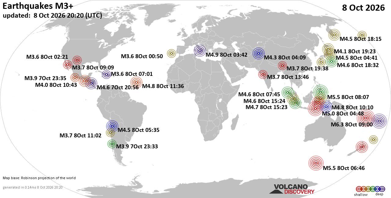
World Earthquake Report for Thursday, 8 October 2026
• M 3.1 - 213 km ESE of Chiniak, Alaska
• M -0.6 - 62 km ENE of Pedro Bay, Alaska
• M 1.2 - 26 km WSW of Westley, CA
• M 0.6 - 83 km NNW of Karluk, Alaska
• M 1.9 - 11 km NNE of Pāhala, Hawaii
|
|
|
Joined: Feb 2001
Posts: 678,977
Launch Director
|
|
Launch Director
Joined: Feb 2001
Posts: 678,977 |
SPC Oct 8, 2026 2000 UTC Day 1 Convective OutlookSPC 2000Z Day 1 Outlook 
Day 1 Convective Outlook
NWS Storm Prediction Center Norman OK
0232 PM CDT Thu Oct 08 2026

Valid 082000Z - 091200Z

...THERE IS A MARGINAL RISK OF SEVERE THUNDERSTORMS ACROSS THE
CENTRAL PORTION OF THE FLORIDA PENINSULA AND IOWA...

...SUMMARY...
Localized severe thunderstorms may occur across the central portion
of the Florida Peninsula and/or across Iowa tonight.

...20Z Update...
The forecast remains on track, and no changes were needed with this
update. See the previous discussion below for details.

..Weinman.. 10/08/2026

.PREV DISCUSSION... /ISSUED 1123 AM CDT Thu Oct 08 2026/

...Florida Peninsula...
Visible-satellite imagery shows a cloud shield generally near and
north of a residual frontal zone draped across the central portion
of the FL Peninsula.  Filtered sunshine generally south of the I-4
corridor will contribute to weak destabilization in the presence of
a tropical airmass characterized by mid-upper 70s deg F surface
dewpoints.  Model forecast soundings show moderate effective shear
(25-30 kt) and a veering wind profile through a deep layer.  Given
the very moist boundary layer coupled with proximity to the frontal
zone and shear supporting potentially transient weak rotation, a
brief tornado or waterspout is possible.

...Iowa...
Isolated to scattered elevated thunderstorms are forecast
tonight in tandem with around 1000 J/kg MUCAPE developing as warm
advection and isentropic ascent increase to the northeast of a
northeastward-advancing warm front.  With effective shear in the
cloud-bearing layer expected to increase to 40+ kt, the possibility
exists for a few elevated supercells late this evening into the
overnight, with a few instances of marginally severe hail possible.
Read morehttps://www.spc.noaa.gov/products/outlook/day1otlk_2000.html
|
|



CMS The Best Conveyancing solicitors conveyancing quotes throughout the UK
For any webhosting enquiries please email webmaster@aus-city.com
|
|
Entire Thread
|

 SPC Oct 8, 2026 2000 UTC Day 1 Convective Outlook
|
Webmaster
|
3 hours ago
|
|
Forums60
Topics864,448
Posts899,243
Members2,960
| |
Most Online102,106
Jul 10th, 2026
|
|
|
|
|

|









































