|
0 members (),
2,422
guests, and
26
robots. |
|
Key:
Admin,
Global Mod,
Mod
|
|
S |
M |
T |
W |
T |
F |
S |
|
|
|
|
|
1
|
2
|
3
|
|
4
|
5
|
6
|
7
|
8
|
9
|
10
|
|
11
|
12
|
13
|
14
|
15
|
16
|
17
|
|
18
|
19
|
20
|
21
|
22
|
23
|
24
|
|
25
|
26
|
27
|
28
|
29
|
30
|
31
|
|
There are no members with birthdays on this day. |
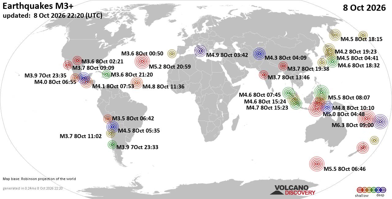
World Earthquake Report for Thursday, 8 October 2026
• M 4.2 - off the coast of Oregon
• M 0.7 - 2 km NE of Imperial Beach, CA
• M 0.1 - 5 km WNW of Cobb, CA
• M 1.4 - 11 km SSE of Malibu Beach, CA
• M 1.6 - 15 km NNW of Fishhook, Alaska
|
|
|
Joined: Feb 2001
Posts: 678,977
Launch Director
|
|
Launch Director
Joined: Feb 2001
Posts: 678,977 |
SPC Day 2 Fire Weather OutlookSPC Day 2 Fire Weather Outlook 
Day 2 Fire Weather Outlook
NWS Storm Prediction Center Norman OK
0212 PM CDT Thu Oct 08 2026

Valid 091200Z - 101200Z

...CRITICAL FIRE WEATHER AREA FOR PORTIONS OF NORTHEAST WYOMING...

The forecast remains on track for Day 2/Friday. A minor expansion
was made to the Critical fire weather risk area across portions of
northeastern Wyoming, where a slightly broader region of sustained
southwesterly winds of 20-25 mph and RH values of 10-20% will
overlap ERCs approaching the 90th percentile. Please see the
previous discussion for additional details.

..Elizalde-Garcia.. 10/08/2026

.PREV DISCUSSION... /ISSUED 1244 AM CDT Thu Oct 08 2026/

...Synopsis...
On Day 2/Friday, an upper-level trough advancing southeastward into
the Pacific Northwest, paired with a surface cold front, will create
impactful fire weather conditions across portions of the northern
and western CONUS. Prolonged dry, warm conditions beneath a
persistent upper-level ridge have significantly cured fuels
throughout the region. Energy Release Components are forecast to
exceed the 80th percentile across the highlighted risk areas prior
to the onset of stronger winds.

...Much of Wyoming, central Montana, southwestern South Dakota, and
far northwest Nebraska...
Enhanced west-southwesterly flow on Day 2/Friday will drive
well-above-normal temperatures and promote seasonally deep
boundary-layer mixing. A tightening surface pressure gradient, tied
to a deepening lee low further north, and a southward progressing
cold front, transiting through Montana around sunset, will bring
drier air into the region with minimum RH values falling to 15 to 20
percent. In tandem, sustained west-southwest surface winds ahead of
the aforementioned front will increase to 15 to 20 mph across much
of the northern High Plains and adjacent terrain, warranting an
Elevated fire weather area.

Furthermore, a Critical fire weather area has been introduced for
portions of northeastern Wyoming. This corridor is expected to
experience the most favorable overlap of strong southwest winds
sustained at 20 to 25 mph, critically low afternoon RH values
between 10 and 20 percent, and highly receptive fuels near the 90th
ERC percentile.

...Southeast Oregon, Northeast California, and the far western Great
Basin...
West-southwesterly flow will similarly support anomalously warm
temperatures and seasonally deep mixing across this region. As the
surface pressure gradient tightens ahead of the approaching cold
front, west-southwest surface winds will strengthen to 15 to 20 mph
and turn toward the northwest as the front passes through
southeastern Oregon in the late afternoon. Combined with afternoon
relative humidity values dropping to near 15 to 20 percent over dry
fuels, these conditions will support a targeted Elevated fire
weather threat.

...Please see www.spc.noaa.gov/fire for graphic product...
Read morehttps://www.spc.noaa.gov/products/fire_wx/fwdy2.html
|
|



CMS The Best Conveyancing solicitors conveyancing quotes throughout the UK
For any webhosting enquiries please email webmaster@aus-city.com
|
|
Entire Thread
|

 SPC Day 2 Fire Weather Outlook
|
Webmaster
|
4 hours ago
|
|
Forums60
Topics864,565
Posts899,360
Members2,960
| |
Most Online102,106
Jul 10th, 2026
|
|
|









































