|
0 members (),
1,953
guests, and
26
robots. |
|
Key:
Admin,
Global Mod,
Mod
|
|
S |
M |
T |
W |
T |
F |
S |
|
|
|
|
|
1
|
2
|
3
|
|
4
|
5
|
6
|
7
|
8
|
9
|
10
|
|
11
|
12
|
13
|
14
|
15
|
16
|
17
|
|
18
|
19
|
20
|
21
|
22
|
23
|
24
|
|
25
|
26
|
27
|
28
|
29
|
30
|
31
|
|
There are no members with birthdays on this day. |
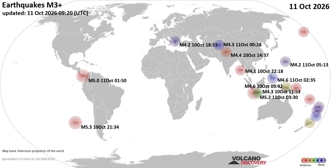
World Earthquake Report for Sunday, 11 October 2026
• M 2.6 - 7 km E of Pearsall, Texas
• M 2.4 - 16 km N of Meadow Lakes, Alaska
• M 2.9 - 16 km NW of Fishhook, Alaska
• M 5.0 - 187 km ENE of Saipan, Northern Mariana Islands
• M 7.7 - 12 km WSW of Pitaloza Arriba, Panama
• M 2.7 - 37 km WNW of Skwentna, Alaska
|
|
|
Joined: Feb 2001
Posts: 678,977
Launch Director
|
|
Launch Director
Joined: Feb 2001
Posts: 678,977 |
SPC Oct 11, 2026 0730 UTC Day 3 Severe Thunderstorm OutlookSPC 0730Z Day 3 Outlook 
Day 3 Convective Outlook
NWS Storm Prediction Center Norman OK
0201 AM CDT Sun Oct 11 2026

Valid 131200Z - 141200Z

...THERE IS A SLIGHT RISK OF SEVERE THUNDERSTORMS OVER PARTS OF THE
CENTRAL AND SOUTHERN HIGH PLAINS...

...SUMMARY...
Widely scattered severe storms appear possible over portions of the
central and southern High Plains Tuesday afternoon into night. More
isolated severe weather may occur into the mid Mississippi Valley,
and in parts of the lower Great Lakes.

...Synopsis...

A midlevel low will slowly progress through the Great Basin with a
downstream belt of enhanced, mid/upper-level flow extending from the
southern Rockies into the Great Lakes. Within that airstream, a
short-wave trough will progress from the Great Lakes into the
Northeast, while a more subtle disturbance advances from the central
and southern High Plains into the Upper Midwest. At the surface, an
area of low pressure associated with the former disturbance
mentioned above is expected to develop from lower MI through the
northern Mid-Atlantic into New England with a boundary trailing that
feature from the southern Great Lakes into the central High Plains,
where it will link with a deepening lee cyclone over southeast CO.


...Central and Southern Plains into the Mid-Mississippi Valley...

While midlevel lapse rates are not forecast to be particularly
steep, daytime heating combined with boundary-layer dewpoints in the
mid 60s to lower 70s is expected to contribute to a moderately
unstable warm sector by afternoon. The specific details regarding
convective evolution remain uncertain; however, forcing for ascent
associated with the midlevel disturbance and convergence in the
vicinity of the synoptic front, dryline, and lee cyclone are likely
to aid in diurnally enhanced thunderstorm development. Highest
confidence in that occurrence remains over portions of southwest KS
into the OK and TX Panhandles, where the low-level mass response to
the deepening CO low will be the greatest from late afternoon into
evening. Vertical shear will be sufficiently strong to support
supercells capable of mainly large hail initially. Tornado potential
may increase during the evening with any ongoing supercells as the
low-level jet strengthens. Upscale growth into one or multiple storm
complexes appears possible, at which point, the threat for damaging
winds would correspondingly increase.

An areal expansion in level-2/Slight Risk probabilities may be
required in later outlooks once finer-scale details become more
clear.


...Lower Great Lakes...

Showers and thunderstorms may be ongoing Monday morning within a
zone of low-level warm advection and moisture transport preceding
the surface low and short-wave trough. Clouds and precipitation may
linger into afternoon, limiting the destabilization in those areas.
However, where stronger heating can occur, the presence of
boundary-layer dewpoints in the 60s will support at least a
marginally unstable environment by afternoon. Both low-level and
deep-layer shear will be relatively strong, and on the condition
that surface-based storms develop and are sustained, the threat for
locally damaging winds and perhaps a tornado or two would exist.

..Mead.. 10/11/2026
Read morehttps://www.spc.noaa.gov/products/outlook/day3otlk_0730.html
|
|



CMS The Best Conveyancing solicitors conveyancing quotes throughout the UK
For any webhosting enquiries please email webmaster@aus-city.com
|
|
Entire Thread
|

 SPC Oct 11, 2026 0730 UTC Day 3 Severe Thunderstorm Outlook
|
Webmaster
|
4 hours ago
|
|
Forums60
Topics868,862
Posts903,658
Members2,960
| |
Most Online102,106
Jul 10th, 2026
|
|
|









































