|
0 members (),
1,417
guests, and
26
robots. |
|
Key:
Admin,
Global Mod,
Mod
|
|
S |
M |
T |
W |
T |
F |
S |
|
|
|
|
|
1
|
2
|
3
|
|
4
|
5
|
6
|
7
|
8
|
9
|
10
|
|
11
|
12
|
13
|
14
|
15
|
16
|
17
|
|
18
|
19
|
20
|
21
|
22
|
23
|
24
|
|
25
|
26
|
27
|
28
|
29
|
30
|
31
|
|
There are no members with birthdays on this day. |
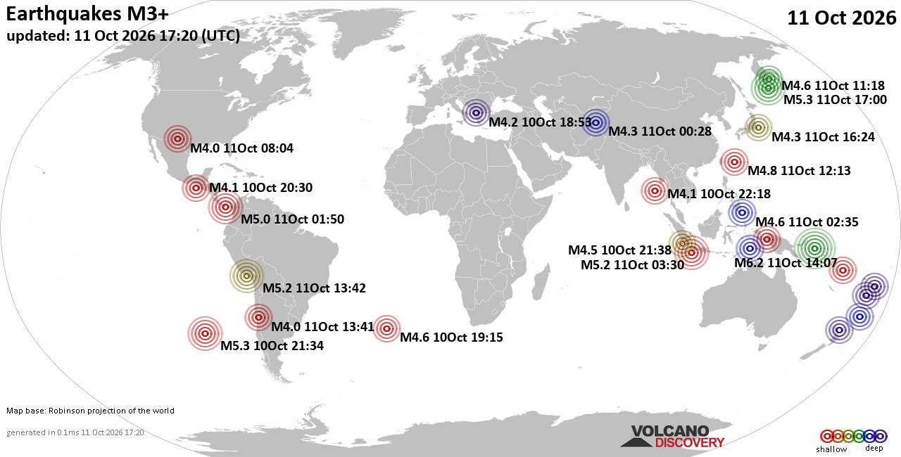
World Earthquake Report for Sunday, 11 October 2026
• Significant magnitude 5.2 earthquake 95 km southwest of Kasivobara, Russia
• M 1.7 - 9 km N of Hollister, CA
• M 1.2 - 9 km N of Borrego Springs, CA
• M 7.7 - 12 km WSW of Pitaloza Arriba, Panama
• Strong mag. 5.2 earthquake - Russia: Near Petropavlovsk Kamchatskiy on Sund...
|
|
|
Joined: Feb 2001
Posts: 678,977
Launch Director
|
|
Launch Director
Joined: Feb 2001
Posts: 678,977 |
Issued at 900 AM CST Sun Oct 11 2026 000
WTPZ45 KNHC 111458
TCDEP5
Hurricane Simon Discussion Number 17
NWS National Hurricane Center Miami FL EP202026
900 AM CST Sun Oct 11 2026
Simon continues to be a powerful Category 4 hurricane as it gets
ever closer to the coast of Mexico this morning. Since the previous
advisory, the eye definition on infrared satellite has cooled
slightly and the overall central dense overcast related to the
eyewall convection has been shrinking in size. There was a helpful
GPM microwave pass at 1152 UTC, showing that the inner core is
showing some hints of disruption, with a larger outer band becoming
more dominant on Simon's northwestward side. The 12 UTC subjective
Dvorak fix was T6.5/125 kt, and the objective satellite estimates
are in the 119-127 kt range, so the initial intensity is being
nudged down to 125 kt for this advisory.
The hurricane has maintained a north-northwestward motion this
morning, or 345 degrees at 5 kt, bringing the hurricane very close
to the coast of Mexico. On Simon's current heading, dangerous wind,
surge, and rainfall effects appear likely over portions of
west-central Mexico in the Hurricane Warning area today. It also
remains possible the hurricane makes direct landfall between Playa
Perula and Cabo Corrientes in the next 12-18 hours. However, like
the previous forecast cycle, the most reliable guidance aids
(HCCA, GDMI, WN3I) have shifted westward once again, and the NHC
track forecast has been shifted in that direction, but due to
continuity constraints is not shifted all the way to those solutions
yet. To make matters even more uncertain, there are some
deterministic global model solutions (00 UTC ECMWF, 06 UTC GFS) that
show Simon turning southwestward near the end of the forecast
period, and that is also seen in a handful of the Google DeepMind
ensemble members. This NHC track continues to favor a track that
stays closer to the coast of Mexico before going inland into Mexico
in 72-96 h. Needless to say, this is a low confidence track forecast
with higher than usual uncertainty given the spread in the
guidance.
The intensity forecast also presents challenges. As mentioned in the
previous discussion, the forecast is sensitive to how close Simon
passes to western Mexico during the next day or so. A track closer
to the coast or inland would likely result in more severe disruption
of Simon's circulation due to the high terrain of the Sierra Madre
mountains, leading to rapid weakening. However, with the track
shifting further offshore, this weakening may not be as severe,
though some negative topographic influence is shown in the majority
of the guidance leading to weakening. However, like the track, the
current intensity forecast is low confidence forecast because only a
small deviation either east or west could result in Simon either
dissipating after landfall or staying much stronger than the current
forecast offshore. The NHC intensity forecast is a compromise
between these extremes.
Key Messages:
1. Catastrophic wind and life-threatening storm surge impacts are
likely along a portion of the west-central coast of Mexico, and a
Hurricane Warning is in effect from Punta San Telmo to El Roblito.
Residents should shelter in a safe room to ride out the storm as the
most significant hazards with Simon are now ongoing.
2. Heavy rainfall associated with Simon will impact portions of
southwestern Mexico through Monday. This rainfall will produce
life-threatening flooding and mudslides, especially in areas of
steep terrain.
3. Swells will affect portions of the southwestern and west-central
coast of Mexico over the next few days. These swells are likely to
cause life-threatening surf and rip current conditions. Please
consult products from your local weather office.
FORECAST POSITIONS AND MAX WINDS
INIT 11/1500Z 19.2N 105.3W 125 KT 145 MPH...NEAR THE COAST
12H 12/0000Z 19.9N 105.6W 105 KT 120 MPH...NEAR THE COAST
24H 12/1200Z 20.5N 106.0W 85 KT 100 MPH...NEAR THE COAST
36H 13/0000Z 21.1N 106.4W 70 KT 80 MPH
48H 13/1200Z 21.8N 106.8W 60 KT 70 MPH
60H 14/0000Z 22.5N 106.9W 50 KT 60 MPH
72H 14/1200Z 23.0N 106.9W 50 KT 60 MPH
96H 15/1200Z 23.9N 106.4W 30 KT 35 MPH...POST-TROP/INLAND
120H 16/1200Z...DISSIPATED
$$
Forecaster Papin Source: Hurricane Simon Forecast Discussion Number 17
|
|



CMS The Best Conveyancing solicitors conveyancing quotes throughout the UK
For any webhosting enquiries please email webmaster@aus-city.com
|
|
Entire Thread
|

 Hurricane Simon Forecast Discussion Number 17
|
Webmaster
|
3 hours ago
|
|
Forums60
Topics869,340
Posts904,136
Members2,960
| |
Most Online102,106
Jul 10th, 2026
|
|
|









































