|
|
|
1 members (Alisa),
3,372
guests, and
22
robots. |
|
Key:
Admin,
Global Mod,
Mod
|
|
S |
M |
T |
W |
T |
F |
S |
|
1
|
2
|
3
|
4
|
5
|
6
|
7
|
|
8
|
9
|
10
|
11
|
12
|
13
|
14
|
|
15
|
16
|
17
|
18
|
19
|
20
|
21
|
|
22
|
23
|
24
|
25
|
26
|
27
|
28
|
|
29
|
30
|
|
|
|
|
|
|
There are no members with birthdays on this day. |
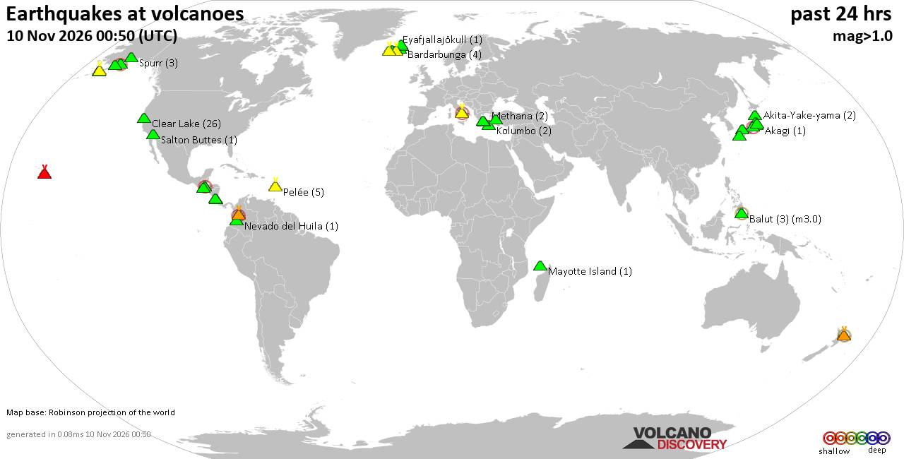
Volcano earthquake report for Tuesday, 10 November 2026
• M 5.7 - 106 km ENE of Hasaki, Japan
• M 3.0 - 52 km N of San Juan, Puerto Rico
• M 1.2 - 7 km NNE of Borrego Springs, CA
• M 3.1 - 265 km SSW of Inuvik, Canada
• M 0.5 - 3 km NE of Anza, CA
|

#911283
Wed 14 Oct 2026 11:50:AM
|
Joined: Feb 2001
Posts: 800,656
Launch Director
|
|
Launch Director
Joined: Feb 2001
Posts: 800,656 |
Volcano earthquake report for Wednesday, 14 October 2026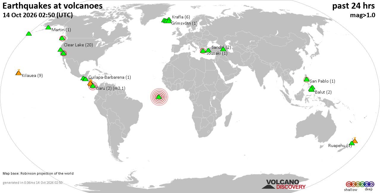 World map showing volcanoes with shallow (less than 50 km) earthquakes within 20 km radius during the past 24 hours on 14 Oct 2026 Number in brackets indicate nr of quakes. Quakes detected near: Apaneca Range (1 quake mag 1.8), Balut (2 quakes between mag 1.9-1.9), Bardarbunga (8 quakes between mag 0.4-1.6), Baru (5 quakes between mag 2.4-3.0), Barva (2 quakes between mag 2.1-2.3), Clear Lake (21 quakes between mag 0.2-1.4)
Cleveland (3 quakes between mag 0.8-1.9), Coso (3 quakes between mag 0.9-2.7), Eldey (4 quakes between mag 1.3-2.9), Fani Maoré (1 quake mag 1.6), Flores (11 quakes between mag 1.3-2.7), Grímsvötn (1 quake mag 1.4), Kilauea (11 quakes between mag 0.8-2.8), Krafla (3 quakes between mag 0.0-1.1), Leonard Range (1 quake mag 1.7), Ljósufjöll (3 quakes between mag 0.7-1.3), Martin (1 quake mag 1.4), Maunaloa (1 quake mag 2.0), Mayotte Island (1 quake mag 1.9), Mono Lake (1 quake mag 1.7), Parker (1 quake mag 1.7), Poas (2 quakes between mag 2.7-3.3), Prestahnukur (6 quakes between mag 0.6-1.9), Rincón de la Vieja (1 quake mag 1.9), Romanche Fracture Zone (1 quake mag 6.8), Ruapehu (1 quake mag 1.1), San Pablo (1 quake mag 2.2), Sousaki (1 quake mag 2.3), Stepovak Bay 4 (1 quake mag 1.6), Svartsengi (1 quake mag 1.9), Tacaná (1 quake mag 2.0), Tana (1 quake mag 1.8), Tendürek Dağ (1 quake mag 1.0), Vatnafjöll (2 quakes between mag 1.0-1.4), White Island (1 quake mag 1.9) (updated 11h50)\n\nNote: Earthquakes within 20 km from and at depths less than 50 km under active volcanoes are reported. The list is not complete because many volcanoes are not monitored and/or seismic data in high resolution is not available publicly.\n
Volcanoes with recent earthquakes above magnitude 2 or more than 10 quakes are listed below:
Baru volcano (Panama): 5 earthquakes up to magnitude 3.05 earthquakes occurred near (under) the volcano during 12 hours, the last being recorded quake 2 hours ago. Hypocenter depths ranged between 36.00 and 0.00 km. Earthquake details: 3.0 quake 50 km northwest of David, Provincia de Chiriqui, Panama, Oct 13, 2026 04:22 pm (Costa_Rica time) (19 km W) 2.7 quake 31 km northwest of David, Provincia de Chiriqui, Panama, Oct 14, 2026 02:17 am (Costa_Rica time) (14 km S) 2.6 quake 27 km north of David, Provincia de Chiriqui, Panama, Oct 14, 2026 03:22 am (Costa_Rica time) (17 km SSE) 2.6 quake 40 km north of David, Provincia de Chiriqui, Panama, Oct 14, 2026 01:18 am (GMT -5) (9 km ESE) 2.4 quake 33 km north of David, Provincia de Chiriqui, Panama, Oct 14, 2026 12:43 am (Costa_Rica time) (12 km S) All earthquakes at BaruBarva volcano (Costa Rica): 2 earthquakes up to magnitude 2.32 earthquakes occurred near (under) the volcano during 13 hours, the last being recorded quake 41 minutes ago. Hypocenter depths ranged between 9.00 and 0.00 km. Earthquake details: 2.3 quake Provincia de Heredia, 20 km north of San Jose, Provincia de San Jose, Costa Rica, Oct 13, 2026 04:18 pm (Costa_Rica time) (4 km ESE) 2.1 quake Provincia de Heredia, 20 km north of San Jose, Provincia de San Jose, Costa Rica, Oct 14, 2026 05:08 am (Costa_Rica time) (4 km SE) All earthquakes at BarvaBarva is a multi-peaked Costa Rican volcano near San José, also recorded as Barba and Las Tres Marías. Its only confirmed eruption dates to around 6050 BCE, while later historical reports are uncertain. Clear Lake volcano (California): 21 earthquakes up to magnitude 1.4Possible earthquake swarm: 21 earthquakes occurred near (under) the volcano during 22 hours, the last being recorded quake 2 hours ago. Hypocenter depths ranged between 8.10 and 0.74 km. Earthquake details: (only 5 largest) 1.4 quake 29 mi north of Santa Rosa, Sonoma County, California, United States, Oct 13, 2026 08:02 pm (GMT -7) (17 km SSW) 1.3 quake 10.1 mi west of Clearlake, Lake County, California, United States, Oct 13, 2026 06:54 pm (GMT -7) (7 km SSW) 1.1 quake 26 mi north of Santa Rosa, Sonoma County, California, United States, Oct 14, 2026 09:48 am (Universal Time) (18 km SSW) 1.1 quake 29 mi north of Santa Rosa, Sonoma County, California, United States, Oct 14, 2026 02:38 am (Universal Time) (17 km SSW) 1.1 quake 26 mi north of Santa Rosa, Sonoma County, California, United States, Oct 13, 2026 03:48 pm (GMT -7) (18 km SSW) All earthquakes at Clear LakeCoso volcano (California): 3 earthquakes up to magnitude 2.73 earthquakes occurred near (under) the volcano during 4 hours, the last being recorded quake 18 hours ago. Hypocenter depths ranged between 1.72 and 1.35 km. Earthquake details: 2.7 quake Inyo County, 29 mi north of Ridgecrest, Kern County, California, United States, Oct 13, 2026 06:55 am (GMT -7) (4 km E) 1.2 quake Inyo County, 28 mi north of Ridgecrest, Kern County, California, United States, Oct 13, 2026 10:45 am (GMT -7) (4 km E) 0.9 quake Inyo County, 28 mi north of Ridgecrest, Kern County, California, United States, Oct 13, 2026 11:12 am (GMT -7) (4 km ESE) All earthquakes at CosoCoso is a 400 km² volcanic field of rhyolitic domes, basaltic cones and lava flows east of the Sierra Nevada Range. Its youngest dated eruption occurred about 39,000 ± 33,000 years ago, while active fumaroles and thermal springs mark an important geothermal area. Eldey volcano (Iceland): 4 earthquakes up to magnitude 2.94 earthquakes occurred near (under) the volcano during 21 minutes, the last being recorded quake 8 hours ago. Hypocenter depths ranged between 10.00 and 7.80 km. Earthquake details: 2.9 quake Irminger Sea, 47 km southwest of Keflavik, Southern Peninsula, Iceland, Oct 14, 2026 04:06 am (Reykjavik time) (13 km WSW) 1.4 quake 2.0 km NNW of Geirfuglasker Oct 14, 2026 04:10 am (Universal Time) (11 km W) 1.4 quake 1.1 km W of Geirfuglasker Oct 14, 2026 03:59 am (Universal Time) (12 km WSW) 1.3 quake Iceland: 1.7 km SSW of Geirfuglasker Oct 14, 2026 04:19 am (Reykjavik time) (12 km WSW) All earthquakes at EldeyEldey is a mostly submarine volcanic system south of Iceland, with only an island and several rocky skerries above water. Five eruptions are confirmed from 1211 to 1926, and an additional event in 1884 is uncertain. Flores volcano (Guatemala): 11 earthquakes up to magnitude 2.7Possible earthquake swarm: 11 earthquakes occurred near (under) the volcano during 17 hours, the last being recorded quake 5 hours ago. Hypocenter depths ranged between 6.90 and 2.00 km. Earthquake details: (only 5 largest) 2.7 quake 23 km northeast of Cuilapa, Departamento de Santa Rosa, Guatemala, Oct 14, 2026 01:05 am (GMT -6) (13 km WNW) 2.1 quake 23 km northeast of Cuilapa, Departamento de Santa Rosa, Guatemala, Oct 13, 2026 04:01 pm (GMT -6) (14 km WNW) 2.1 quake 24 km northeast of Cuilapa, Departamento de Santa Rosa, Guatemala, Oct 13, 2026 02:53 pm (GMT -6) (14 km WNW) 2.1 quake 21 km west of Jutiapa, Departamento de Jutiapa, Guatemala, Oct 13, 2026 10:09 am (GMT -6) (10 km WNW) 2.0 quake 22 km northeast of Cuilapa, Departamento de Santa Rosa, Guatemala, Oct 13, 2026 03:59 pm (GMT -6) (14 km WNW) All earthquakes at FloresFlores, also known as Volcán Amayo, is a volcanic field about 10 km west of Jutiapa in southeastern Guatemala. Its last eruption is undated, and none are known from approximately the past 11,700 years. Kilauea volcano (Hawai'i (Big Island)): 11 earthquakes up to magnitude 2.8Possible earthquake swarm: 11 earthquakes occurred near (under) the volcano during 18 hours, the last being recorded quake 54 minutes ago. Hypocenter depths ranged between 37.67 and 1.36 km. Earthquake details: (only 5 largest) 2.8 quake 25 mi southwest of Hilo, Hawaii County, Hawaii, United States, Oct 14, 2026 12:56 am (GMT -10) (5 km ESE) 2.4 quake 27 mi southwest of Hilo, Hawaii County, Hawaii, United States, Oct 13, 2026 07:06 am (GMT -10) (4 km SSE) 2.2 quake 23 mi southwest of Hilo, Hawaii County, Hawaii, United States, Oct 14, 2026 12:50 am (GMT -10) (3 km ENE) 2.1 quake 24 mi southwest of Hilo, Hawaii County, Hawaii, United States, Oct 14, 2026 12:47 am (GMT -10) (5 km ESE) 2.1 quake 27 mi southwest of Hilo, Hawaii County, Hawaii, United States, Oct 13, 2026 11:08 am (GMT -10) (4 km SSE) All earthquakes at KilaueaPoas volcano (Costa Rica): 2 earthquakes up to magnitude 3.32 earthquakes occurred near (under) the volcano during 4 hours, the last being recorded quake 17 hours ago. Hypocenter depths ranged between 25.00 and 10.00 km. Earthquake details: 3.3 quake Provincia de Alajuela, 29 km northwest of San Jose, Costa Rica, Oct 13, 2026 01:02 pm (GMT -6) (9 km SSW) 2.7 quake Provincia de Alajuela, 32 km northwest of San Jose, Costa Rica, Oct 13, 2026 08:33 am (GMT -6) (18 km SW) All earthquakes at PoasPoás is an active Costa Rican volcano about 35 km northwest of San José. Its highly acidic Laguna Caliente is the source of frequent steam-driven explosions, including activity recorded during 2025 and 2026. Romanche Fracture Zone volcano (Atlantic Ocean): magnitude 6.8 earthquakeA magnitude 6.8 earthquake occurred at the volcano 23 hours ago. The quake, which might be volcanic in origin, was located at a depth of 10.00 km depth at 19 km distance E from the volcano. Earthquake details: 6.8 quake Central Mid-Atlantic Ridge Oct 13, 2026 11:23 am (GMT -1) (19 km E) All earthquakes at Romanche Fracture ZoneRomanche Fracture Zone is a submarine fissure-vent cluster in the central Atlantic Ocean. Three possible eruptions were reported between 1761 and 1836, but all remain uncertain. San Pablo volcano (Luzon Island): magnitude 2.2 earthquakeA magnitude 2.2 earthquake occurred at the volcano 20 hours ago. The quake, which might be volcanic in origin, was located at a depth of 32.00 km depth at 14 km distance WSW from the volcano. Earthquake details: 2.2 quake Province of Batangas, 17 km south of Calamba, Philippines, Oct 13, 2026 11:26 pm (GMT +8) (14 km WSW) All earthquakes at San PabloSan Pablo is a field of volcanic cones and maars beside Laguna de Bay on Luzon. Its only confirmed eruptive period is dated to around 1350 CE and involved an explosion at Sampaloc Lake. Sousaki volcano (Greece): magnitude 2.3 earthquakeA magnitude 2.3 earthquake occurred at the volcano 10 hours ago. The quake, which might be volcanic in origin, was located at a depth of 10.00 km depth at 16 km distance WNW from the volcano. Earthquake details: 2.3 quake Ionian Sea, 5.9 km northwest of Corinth, Nomos Korinthias, Peloponnese, Greece, Oct 14, 2026 04:51 am (GMT +3) (16 km WNW) All earthquakes at Sousakihttps://www.volcanodiscovery.com/earthquakes-volcanoes/news/378216/Volcano-earthquake-report-2026-10-14.html
|
|



CMS The Best Conveyancing solicitors conveyancing quotes throughout the UK
For any webhosting enquiries please email webmaster@aus-city.com
|
|
Entire Thread
|
 Volcano earthquake report for Wednesday, 14 October 2026 |
Webmaster
|
Wed 14 Oct 2026 11:50:AM
|
|
Forums60
Topics919,753
Posts954,550
Members2,960
| |
Most Online102,106
Jul 10th, 2026
|
|
|
|
|

|









































