|
|
|
0 members (),
1,393
guests, and
27
robots. |
|
Key:
Admin,
Global Mod,
Mod
|
|
S |
M |
T |
W |
T |
F |
S |
|
|
|
|
|
1
|
2
|
3
|
|
4
|
5
|
6
|
7
|
8
|
9
|
10
|
|
11
|
12
|
13
|
14
|
15
|
16
|
17
|
|
18
|
19
|
20
|
21
|
22
|
23
|
24
|
|
25
|
26
|
27
|
28
|
29
|
30
|
31
|
|
There are no members with birthdays on this day. |

World Earthquake Report for Wednesday, 21 October 2026
• M 4.0 - 56 km S of Whites City, New Mexico
• M 5.1 - 164 km NE of Lospalos, Timor Leste
• M 5.1 - 164 km NE of Lospalos, Timor Leste
• M 2.2 - 56 km S of Whites City, New Mexico
• M 2.1 - 3 km SW of Anderson Springs, CA
|
|
|
Joined: Feb 2001
Posts: 678,977
Launch Director
|
|
Launch Director
Joined: Feb 2001
Posts: 678,977 |
SPC Day 2 Fire Weather OutlookSPC Day 2 Fire Weather Outlook 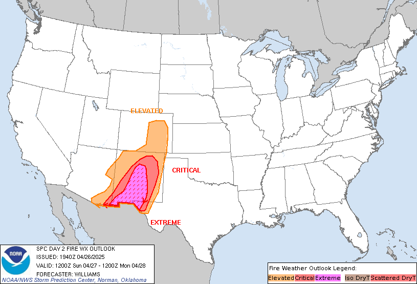
Day 2 Fire Weather Outlook
NWS Storm Prediction Center Norman OK
1159 PM CDT Tue Oct 20 2026

Valid 221200Z - 231200Z

...NO CRITICAL AREAS...

...Synopsis...
An upper low will pivot into CA and the Great Basin D2/Thursday
bringing cloud cover, cooler temperatures and precipitation back
into the Southwestern U.S. during the day, reaching the Northern
Rockies by Thursday night. This will alleviate a broader fire
weather threat across much the West. An upper-level ridge situated
over the Plains accompanied by an expansive surface high pressure
across the eastern U.S. will persist through Thursday. Light
northerly flow will shunt Gulf moisture southward, leading to
appreciably low RH values of 15-20% during the day over the lower MS
River Valley and portions of the Southeast where fuels remain dry.
However, weak boundary layer flow will limit afternoon wind speeds
to less than 10 mph, mitigating significant fire weather concerns.

..Williams.. 10/21/2026

...Please see www.spc.noaa.gov/fire for graphic product...
Read morehttps://www.spc.noaa.gov/products/fire_wx/fwdy2.html
|
|



CMS The Best Conveyancing solicitors conveyancing quotes throughout the UK
For any webhosting enquiries please email webmaster@aus-city.com
|
|
Entire Thread
|

 SPC Day 2 Fire Weather Outlook |
Webmaster
|
5 hours ago
|
|
Forums60
Topics886,238
Posts921,035
Members2,960
| |
Most Online102,106
Jul 10th, 2026
|
|
|
|
|

|









































