|
0 members (),
1,547
guests, and
23
robots. |
|
Key:
Admin,
Global Mod,
Mod
|
|
S |
M |
T |
W |
T |
F |
S |
|
|
|
|
|
1
|
2
|
3
|
|
4
|
5
|
6
|
7
|
8
|
9
|
10
|
|
11
|
12
|
13
|
14
|
15
|
16
|
17
|
|
18
|
19
|
20
|
21
|
22
|
23
|
24
|
|
25
|
26
|
27
|
28
|
29
|
30
|
31
|
|
There are no members with birthdays on this day. |
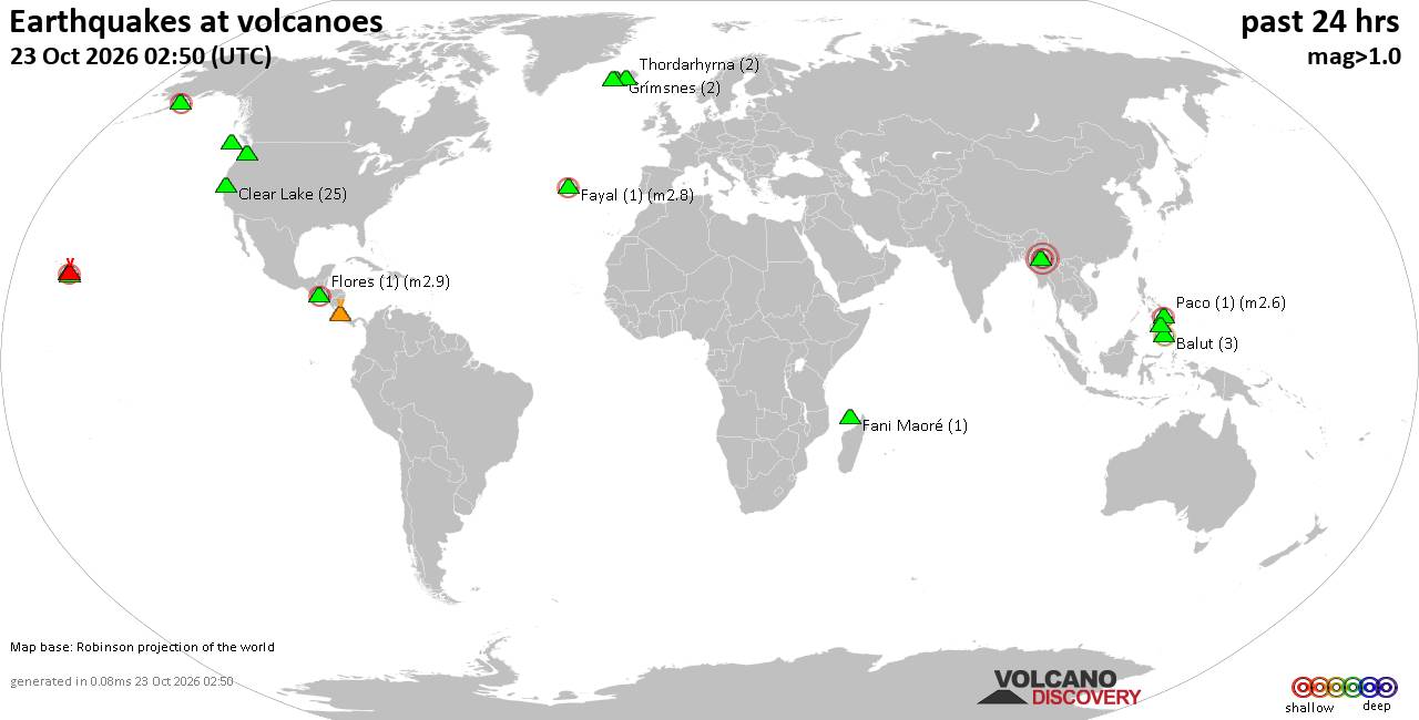
Volcano earthquake report for Friday, 23 October 2026
• M 4.0 - 42 km SSE of Acajutla, El Salvador
• M 3.2 - 23 km WSW of Gustine, CA
• M 0.6 - 22 km WSW of Dutch Harbor, Alaska
• M 0.6 - 43 km ENE of Pedro Bay, Alaska
• M 4.8 - 131 km ENE of Tadine, New Caledonia
|
|
|
Joined: Feb 2001
Posts: 678,977
Launch Director
|
|
Launch Director
Joined: Feb 2001
Posts: 678,977 |
Issued at 900 PM CST Thu Oct 22 2026 658
WTPZ42 KNHC 230239
TCDEP2
Tropical Storm Vance Discussion Number 7
NWS National Hurricane Center Miami FL EP222026
900 PM CST Thu Oct 22 2026
Satellite imagery indicates that Vance continues to become better
organized, with an expanding Central Dense Overcast, a well-defined
curved convective band wrapping into the circulation from the south,
and cloud-top temperatures as cold as -85 C. Upper-level outflow
remains well established, and recent microwave imagery reveals an
improvement in the inner-core structure compared to several hours
ago. The latest subjective Dvorak intensity estimate from TAFB was
T4.0/65 kt, in good agreement with UW-CIMSS objective estimates
ranging from 55 to 65 kt. Given these estimates and the continued
improvement in satellite presentation, the initial intensity is
raised to a conservative 60 kt.
Vance has turned northwestward, and the initial motion is estimated
at 325/5 kt. The cyclone should continue moving northwestward along
the southwestern periphery of a mid-level ridge extending over
Mexico into early Friday. A gradual turn toward the north-northwest
is expected during the next couple of days as the ridge weakens in
response to an upper-level trough over the southwestern United
States. The latest track guidance remains in good agreement through
about 60 h. Thereafter, the trough is expected to shift eastward,
leaving Vance in a region of weaker steering currents and resulting
in increasing spread among the guidance solutions. The regional
hurricane models and GFS favor a more westward track away from the
coast between days 4 and 5, while the GDMI, HCCA, TVCN, and ECMWF
maintain a more north-northwestward track toward the southwestern
and west-central coast of Mexico. Given these persistent differences
in the extended guidance, the NHC track forecast is largely
unchanged from the previous prediction and remains close to the GDMI
and HCCA aids.
Environmental conditions are expected to remain favorable for
significant strengthening during the next couple of days,
characterized by warm sea surface temperatures, low vertical wind
shear, and plenty of mid-level moisture. Guidance continues to
indicate a high likelihood of rapid intensification (RI), with
probabilities from the GFS- and ECMWF-based statistical guidance
reaching 65 to 80 percent during the next 24 h, well above
climatological values. Accordingly, the NHC intensity forecast
explicitly calls for RI during the next 24 h, with Vance forecast to
become a major hurricane by early Saturday. Thereafter, the cyclone
could encounter relatively cooler waters, potentially influenced by
upwelling associated with recent tropical cyclones, along with
increasing vertical wind shear. These factors should limit further
strengthening and support gradual weakening beginning around 60 h.
The NHC intensity forecast is similar to the previous prediction and
remains near the upper end of the guidance envelope through much of
the forecast period.
FORECAST POSITIONS AND MAX WINDS
INIT 23/0300Z 10.5N 101.9W 60 KT 70 MPH
12H 23/1200Z 10.9N 102.2W 80 KT 90 MPH
24H 24/0000Z 11.7N 102.8W 95 KT 110 MPH
36H 24/1200Z 12.5N 103.1W 105 KT 120 MPH
48H 25/0000Z 13.6N 103.5W 100 KT 115 MPH
60H 25/1200Z 14.7N 103.8W 95 KT 110 MPH
72H 26/0000Z 15.7N 104.1W 90 KT 105 MPH
96H 27/0000Z 16.7N 104.4W 90 KT 105 MPH
120H 28/0000Z 17.3N 104.6W 85 KT 100 MPH
$$
Forecaster Gibbs Source: Tropical Storm Vance Forecast Discussion Number 7
|
|



CMS The Best Conveyancing solicitors conveyancing quotes throughout the UK
For any webhosting enquiries please email webmaster@aus-city.com
|
|
Entire Thread
|

 Tropical Storm Vance Forecast Discussion Number 7 |
Webmaster
|
3 hours ago
|
|
Forums60
Topics889,849
Posts924,646
Members2,960
| |
Most Online102,106
Jul 10th, 2026
|
|
|









































