|
|
|
0 members (),
2,876
guests, and
27
robots. |
|
Key:
Admin,
Global Mod,
Mod
|
|
S |
M |
T |
W |
T |
F |
S |
|
1
|
2
|
3
|
4
|
5
|
6
|
7
|
|
8
|
9
|
10
|
11
|
12
|
13
|
14
|
|
15
|
16
|
17
|
18
|
19
|
20
|
21
|
|
22
|
23
|
24
|
25
|
26
|
27
|
28
|
|
29
|
30
|
|
|
|
|
|
|
There are no members with birthdays on this day. |
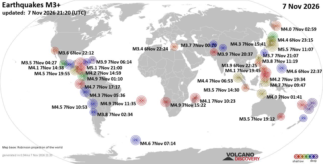
World Earthquake Report for Saturday, 7 November 2026
• Light mag. 3.9 earthquake - Indian Ocean, 115 km south of Banjar, Kabupaten...
• M 1.3 - 6 km NW of The Geysers, CA
• M 4.7 - 43 km ESE of Ambon, Indonesia
• M 5.5 - 10 km NW of Hamakita, Japan
• M 1.8 - 13 km W of Kalifornsky, Alaska
|

#928018
Fri 23 Oct 2026 10:50:PM
|
Joined: Feb 2001
Posts: 800,656
Launch Director
|
|
Launch Director
Joined: Feb 2001
Posts: 800,656 |
Volcano earthquake report for Friday, 23 October 2026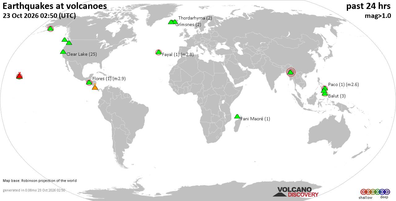 World map showing volcanoes with shallow (less than 50 km) earthquakes within 20 km radius during the past 24 hours on 23 Oct 2026 Number in brackets indicate nr of quakes. Quakes detected near: Agua (2 quakes between mag 1.1-1.2), Askja (6 quakes between mag 0.1-2.2), Balut (8 quakes between mag 1.3-2.5), Barva (1 quake mag 1.4), Binuluan (1 quake mag 2.6), Brennisteinsfjöll (2 quakes between mag 0.4-1.6)
Chingo (1 quake mag 1.8), Clear Lake (18 quakes between mag 0.2-1.7), El Hierro (1 quake mag 2.0), Eldey (1 quake mag 1.1), Fani Maoré (2 quakes between mag 1.6-1.6), Fayal (1 quake mag 2.8), Flores (6 quakes between mag 1.1-3.0), Irazu (1 quake mag 1.1), Jan Mayen (1 quake mag 1.8), Kilauea (4 quakes between mag 1.1-1.8), Kverkfjöll (1 quake mag 1.1), Mageik (2 quakes between mag 0.4-1.1), Malindang (1 quake mag 1.2), Maunaloa (1 quake mag 1.8), Okataina (Tarawera) (1 quake mag 1.8), Prestahnukur (1 quake mag 1.0), Sangay (Philippines) (1 quake mag 2.2), Singu Plateau (1 quake mag 3.6), Svartsengi (29 quakes between mag 0.0-1.9), Tenerife (1 quake mag 1.1), Tjörnes Fracture Zone (1 quake mag 1.4), Torfajökull (1 quake mag 2.3), White Island (1 quake mag 2.1) (updated 22h50)\n\nNote: Earthquakes within 20 km from and at depths less than 50 km under active volcanoes are reported. The list is not complete because many volcanoes are not monitored and/or seismic data in high resolution is not available publicly.\n
Volcanoes with recent earthquakes above magnitude 2 or more than 10 quakes are listed below:
Askja volcano (Iceland): 6 earthquakes up to magnitude 2.26 earthquakes occurred near (under) the volcano during 19 hours, the last being recorded quake 2 hours ago. Hypocenter depths ranged between 7.40 and 0.00 km. Earthquake details: (only 5 largest) 2.2 quake 2.1 km SSW of Víti Oct 23, 2026 03:02 pm (Universal Time) (0 km E) 0.6 quake Iceland: 4.2 km N of Dreki Oct 23, 2026 08:45 pm (Reykjavik time) (9 km NE) 0.3 quake 1.5 km ENE of Suðurbotnar Oct 23, 2026 04:48 am (Universal Time) (4 km E) 0.2 quake Iceland: 9.2 km SSE of Suðurbotnar Oct 23, 2026 05:52 pm (Reykjavik time) (12 km SE) 0.2 quake Iceland: 0.5 km NW of Víti Oct 23, 2026 01:51 am (Reykjavik time) (2 km NNE) All earthquakes at AskjaAskja is a central Icelandic volcano whose major 1875 eruption created the caldera now filled by Öskjuvatn lake. Its last known eruption occurred in 1961. Balut volcano (Mindanao): 8 earthquakes up to magnitude 2.58 earthquakes occurred near (under) the volcano during 11 hours, the last being recorded quake 4 hours ago. Hypocenter depths ranged between 37.00 and 26.00 km. Earthquake details: (only 5 largest) 2.5 quake Philippine Sea, 8.4 km west of Sarangani Island, Philippines, Oct 23, 2026 09:42 pm (GMT +8) (5 km NNE) 2.1 quake Celebes Sea, 26 km west of Sarangani Island, Philippines, Oct 23, 2026 03:51 pm (GMT +8) (14 km W) 1.6 quake Celebes Sea, 22 km southwest of Sarangani Island, Philippines, Oct 24, 2026 02:57 am (GMT +8) (11 km SSW) 1.5 quake Province of Davao del Sur, Davao, 48 km southeast of Glan, Philippines, Oct 24, 2026 12:09 am (GMT +8) (4 km N) 1.5 quake Philippine Sea, 8 km north of Sarangani Island, Philippines, Oct 23, 2026 08:22 pm (GMT +8) (19 km NE) All earthquakes at BalutBalut is an 840 m island stratovolcano south of Mindanao whose last known eruption occurred between about 2 million and 11,700 years ago. Hot springs and thermally altered ground occur on its western and southwestern flanks. Binuluan volcano (Luzon Island): magnitude 2.6 earthquakeA magnitude 2.6 earthquake occurred at the volcano 32 minutes ago. The quake, which might be volcanic in origin, was located at a depth of 14.00 km depth at 8 km distance SE from the volcano. Earthquake details: 2.6 quake 21 km southwest of Tabuk, Kalinga, Cordillera Administrative Region, Philippines, Oct 24, 2026 06:18 am (GMT +8) (8 km SE) All earthquakes at BinuluanClear Lake volcano (California): 18 earthquakes up to magnitude 1.7Possible earthquake swarm: 18 earthquakes occurred near (under) the volcano during 18 hours, the last being recorded quake 6 hours ago. Hypocenter depths ranged between 3.26 and 0.59 km. Earthquake details: (only 5 largest) 1.7 quake Sonoma County, 14 mi southwest of Clearlake, Lake County, California, United States, Oct 22, 2026 04:13 pm (GMT -7) (18 km SSW) 1.5 quake 25 mi north of Santa Rosa, Sonoma County, California, United States, Oct 22, 2026 06:14 pm (GMT -7) (19 km S) 1.3 quake 27 mi north of Santa Rosa, Sonoma County, California, United States, Oct 23, 2026 01:20 am (GMT -7) (17 km S) 1.2 quake 28 mi north of Santa Rosa, Sonoma County, California, United States, Oct 23, 2026 05:04 am (GMT -7) (15 km SSW) 1.1 quake 28 mi north of Santa Rosa, Sonoma County, California, United States, Oct 23, 2026 06:00 am (GMT -7) (16 km SSW) All earthquakes at Clear LakeFayal volcano (Azores): magnitude 2.8 earthquakeA magnitude 2.8 earthquake occurred at the volcano 24 hours ago. The quake, which might be volcanic in origin, was located at a depth of 4.00 km depth at 19 km distance WNW from the volcano. Earthquake details: 2.8 quake North Atlantic Ocean, 33 km northwest of Ribeira Grande, Azores, Portugal, Oct 22, 2026 11:18 pm (Universal Time) (19 km WNW) All earthquakes at FayalFayal is a volcanic island in Portugal’s central Azores. Its 1957–58 Capelinhos eruption created new land offshore that soon joined the island’s western peninsula. Flores volcano (Guatemala): 6 earthquakes up to magnitude 3.06 earthquakes occurred near (under) the volcano during 18 hours, the last being recorded quake 5 hours ago. Hypocenter depths ranged between 8.20 and 3.50 km. Earthquake details: (only 5 largest) 3.0 quake 23 km northeast of Cuilapa, Departamento de Santa Rosa, Guatemala, Oct 23, 2026 05:39 am (GMT -6) (14 km WNW) 3.0 quake 23 km northeast of Cuilapa, Departamento de Santa Rosa, Guatemala, Oct 23, 2026 11:39 am (GMT -6) (14 km WNW) 1.5 quake 22 km northeast of Cuilapa, Departamento de Santa Rosa, Guatemala, Oct 23, 2026 05:40 am (GMT -6) (14 km WNW) 1.5 quake 25 km west of Jutiapa, Departamento de Jutiapa, Guatemala, Oct 22, 2026 05:53 pm (GMT -6) (14 km WNW) 1.2 quake 21 km northeast of Cuilapa, Departamento de Santa Rosa, Guatemala, Oct 22, 2026 06:00 pm (GMT -6) (16 km WNW) All earthquakes at FloresFlores, also known as Volcán Amayo, is a volcanic field about 10 km west of Jutiapa in southeastern Guatemala. Its last eruption is undated, and none are known from approximately the past 11,700 years. Sangay (Philippines) volcano (Luzon Island): magnitude 2.2 earthquakeA magnitude 2.2 earthquake occurred at the volcano 9 hours ago. The quake, which might be volcanic in origin, was located at a depth of 12.00 km depth at 16 km distance ENE from the volcano. Earthquake details: 2.2 quake Philippine Sea, 31 km northeast of Iriga City, Philippines, Oct 23, 2026 09:22 pm (GMT +8) (16 km ENE) All earthquakes at Sangay (Philippines)Sangay is a poorly documented volcano in the Philippines with dated material about 556,000 to 387,000 years old. No eruptions are known during approximately the past 12,000 years. Singu Plateau volcano (Myanmar): magnitude 3.6 earthquakeA magnitude 3.6 earthquake occurred at the volcano 24 hours ago. The quake, which might be volcanic in origin, was located at a depth of 10.00 km depth at 19 km distance E from the volcano. Earthquake details: 3.6 quake Nay Pyi Taw, 42 km southwest of Mogok, Mandalay Region, Myanmar, Oct 23, 2026 05:28 am (GMT +6:30) (19 km E) All earthquakes at Singu PlateauSingu Plateau is a cluster of fissure vents and extensive lava flows in north-central Burma (Myanmar). Five of its youngest dated flows are approximately 250,000–310,000 years old. Svartsengi volcano (Reykjanes Peninsula, Iceland): 29 earthquakes up to magnitude 1.9Possible earthquake swarm: 29 earthquakes occurred near (under) the volcano during 17 hours, the last being recorded quake 45 minutes ago. Hypocenter depths ranged between 7.50 and 0.00 km. Earthquake details: (only 5 largest) 1.9 quake 3.9 km NW of Reykjanestá Oct 23, 2026 05:13 am (Universal Time) (3 km W) 1.4 quake 3.9 km NNW of Reykjanestá Oct 23, 2026 05:10 am (Universal Time) (2 km NW) 1.2 quake 3.8 km NW of Reykjanestá Oct 23, 2026 12:31 pm (Universal Time) (3 km W) 1.2 quake 3.7 km NW of Reykjanestá Oct 23, 2026 05:10 am (Universal Time) (2 km NW) 1.1 quake Iceland: 3.6 km WNW of Reykjanestá Oct 23, 2026 05:24 am (Reykjavik time) (3 km W) All earthquakes at SvartsengiSvartsengi is a fissure-dominated volcanic system on Iceland’s Reykjanes Peninsula. Repeated lava-producing eruptions occurred near Sundhnúkagígar from December 2023 through August 2025. Torfajökull volcano (Iceland): magnitude 2.3 earthquakeA magnitude 2.3 earthquake occurred at the volcano 43 minutes ago. The quake, which might be volcanic in origin, was located at a depth of 5.20 km depth at 8 km distance W from the volcano. Earthquake details: 2.3 quake 9.4 km NW of Álftavatn Oct 23, 2026 10:07 pm (Universal Time) (8 km W) All earthquakes at TorfajökullTorfajökull contains Iceland’s largest exposed area of silicic and intermediate volcanism. Ten recorded eruptive periods span about 8,000 years, with the last known eruption in 1477. Unnamed volcano (North of Luzon): magnitude 2.3 earthquakeA magnitude 2.3 earthquake occurred at the volcano 10 hours ago. The quake, which might be volcanic in origin, was located at a depth of 27.00 km depth at 16 km distance SSE from the volcano. Earthquake details: 2.3 quake South China Sea, 34 km southwest of Basco, Philippines, Oct 23, 2026 08:43 pm (GMT +8) (16 km SSE) All earthquakes at UnnamedUnnamed 24.00°N/121.83°E volcano (Taiwan): 2 earthquakes up to magnitude 4.92 earthquakes occurred near (under) the volcano during 10 minutes, the last being recorded quake 1 hour 52 minutes ago. Hypocenter depths ranged between 16.70 and 13.82 km. Earthquake details: 4.9 quake Philippine Sea, 36 km southeast of Hualien City, Taiwan, Oct 24, 2026 04:48 am (GMT +8) (19 km SSE) 4.6 quake Philippine Sea, 32 km east of Hualien City, Taiwan, Oct 24, 2026 04:58 am (GMT +8) (14 km SSE) All earthquakes at Unnamed 24.00°N/121.83°EWhite Island volcano (New Zealand): magnitude 2.1 earthquakeA magnitude 2.1 earthquake occurred at the volcano 10 hours ago. The quake, which might be volcanic in origin, was located at a depth of 5.00 km depth at 12 km distance N from the volcano. Earthquake details: 2.1 quake South Pacific Ocean, 63 km north of Whakatane, Bay of Plenty, New Zealand, Oct 24, 2026 01:58 am (GMT +13) (12 km N) All earthquakes at White IslandWhakaari/White Island is an active offshore stratovolcano in New Zealand’s Bay of Plenty. A deadly explosion struck visitors in December 2019, and further eruptive activity was recorded in 2024–26. https://www.volcanodiscovery.com/earthquakes-volcanoes/news/385524/Volcano-earthquake-report-2026-10-23.html
|
|



CMS The Best Conveyancing solicitors conveyancing quotes throughout the UK
For any webhosting enquiries please email webmaster@aus-city.com
|
|
Entire Thread
|
 Volcano earthquake report for Friday, 23 October 2026 |
Webmaster
|
Fri 23 Oct 2026 10:50:PM
|
|
Forums60
Topics916,306
Posts951,103
Members2,960
| |
Most Online102,106
Jul 10th, 2026
|
|
|
|
|

|









































