|
0 members (),
1,112
guests, and
30
robots. |
|
Key:
Admin,
Global Mod,
Mod
|
|
S |
M |
T |
W |
T |
F |
S |
|
|
|
|
|
1
|
2
|
3
|
|
4
|
5
|
6
|
7
|
8
|
9
|
10
|
|
11
|
12
|
13
|
14
|
15
|
16
|
17
|
|
18
|
19
|
20
|
21
|
22
|
23
|
24
|
|
25
|
26
|
27
|
28
|
29
|
30
|
31
|
|
There are no members with birthdays on this day. |
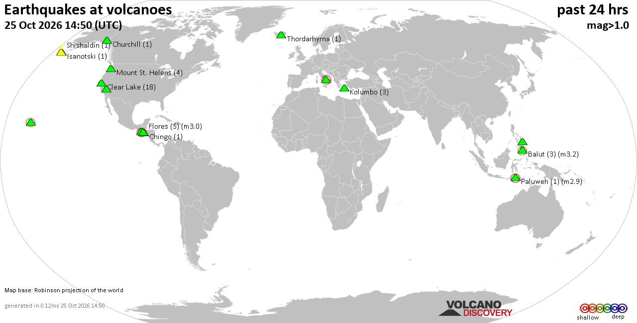
Volcano earthquake report for Sunday, 25 October 2026
• M 1.4 - 10 km ENE of Coso Junction, CA
• M 1.4 - 6 km NNE of North Shore, CA
• M 0.8 - 8 km ENE of Coso Junction, CA
• M 1.6 - 5 km WNW of Yucaipa, CA
• M 5.9 - 218 km ENE of Nagqu, China
• M 1.6 - 12 km E of Coso Junction, CA
|
|
|
Joined: Feb 2001
Posts: 678,977
Launch Director
|
|
Launch Director
Joined: Feb 2001
Posts: 678,977 |
Central Pacific Tropical Weather Outlook


000
ACPN50 PHFO 251133
TWOCP
Tropical Weather Outlook
NWS Central Pacific Hurricane Center Honolulu HI
Issued by NWS National Hurricane Center Miami FL
200 AM HST Sun Oct 25 2026
For the central North Pacific...between 140W and 180W:
Active Systems:
The National Hurricane Center is issuing advisories on Hurricane
Vance, located a few hundred miles southwest of Acapulco, Mexico.
Western Central Pacific:
Showers and thunderstorms continue to show signs of organization
with an area of low pressure just crossing the International Date
Line, several hundred miles west of Johnston Atoll. Earlier
satellite wind data indicated that the circulation was also becoming
better defined. If these current trends continue, the system is
likely to become a tropical depression, possibly as soon as later
today. The system is moving towards the east-northeast at 10 to 15
mph and will slowly approach the Johnston Atoll later this week. By
the middle of the week, however, strong upper-level winds should
limit additional development of the system.
* Formation chance through 48 hours...high...70 percent.
* Formation chance through 7 days...high...70 percent.
$$
Forecaster Papin
NNNN
|
|



CMS The Best Conveyancing solicitors conveyancing quotes throughout the UK
For any webhosting enquiries please email webmaster@aus-city.com
|
|
Entire Thread
|

 Central Pacific Tropical Weather Outlook |
Webmaster
|
3 hours ago
|
|
Forums60
Topics893,332
Posts928,129
Members2,960
| |
Most Online102,106
Jul 10th, 2026
|
|
|









































