|
|
|
0 members (),
1,790
guests, and
44
robots. |
|
Key:
Admin,
Global Mod,
Mod
|
|
S |
M |
T |
W |
T |
F |
S |
|
1
|
2
|
3
|
4
|
5
|
6
|
7
|
|
8
|
9
|
10
|
11
|
12
|
13
|
14
|
|
15
|
16
|
17
|
18
|
19
|
20
|
21
|
|
22
|
23
|
24
|
25
|
26
|
27
|
28
|
|
29
|
30
|
|
|
|
|
|
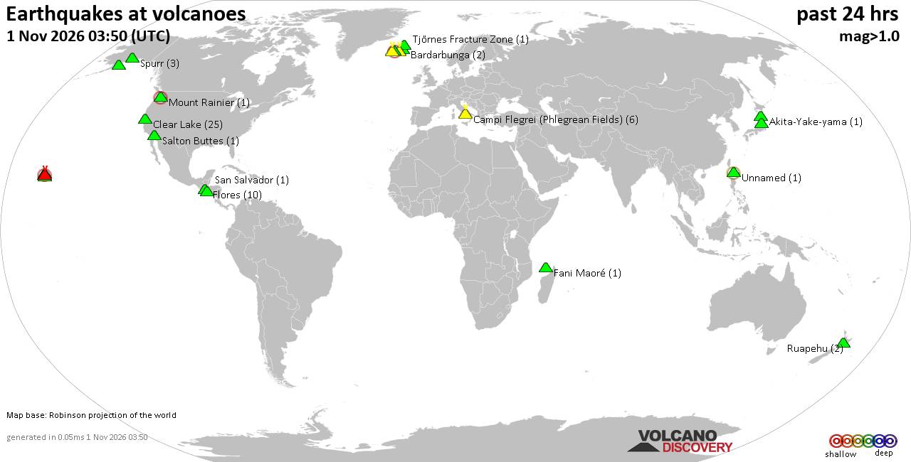
Volcano earthquake report for Sunday, 1 November 2026
• M 1.8 - 6 km S of Pāhala, Hawaii
• M 3.4 - 51 km SSW of Nikolski, Alaska
• M 2.5 - 27 km WSW of Westley, CA
• M 2.7 - 10 km WSW of Stanton, Texas
• M 0.6 - 72 km WNW of Beluga, Alaska
• M 0.7 - 3 km WNW of Julian, CA
|
|
|
Joined: Feb 2001
Posts: 678,977
Launch Director
|
|
Launch Director
Joined: Feb 2001
Posts: 678,977 |
SPC Nov 1, 2026 0600 UTC Day 1 Convective OutlookSPC 1200Z Day 1 Outlook 
Day 1 Convective Outlook CORR 1
NWS Storm Prediction Center Norman OK
0107 AM CDT Sun Nov 01 2026

Valid 011200Z - 021200Z

...THERE IS A SLIGHT RISK OF SEVERE THUNDERSTORMS ACROSS PARTS OF
THE SOUTHERN HIGH PLAINS...

CORRECTED FOR WORDING

...SUMMARY...
Thunderstorms associated with severe wind gusts and a tornado threat
are expected this evening into tonight from parts of New Mexico
northeastward into the southern High Plains. A more isolated severe
threat will be possible in parts of the Desert Southwest this
afternoon.

...Desert Southwest/Southern Rockies/Southern High Plains...
A mid-level shortwave trough will move across California into the
Desert Southwest today. Ahead of the system, a sufficiently moist
airmass will be in place across parts of southern and central
Arizona, where scattered thunderstorms will develop during the
afternoon. Large-scale ascent and strong deep-layer shear will
support an isolated severe threat with cells that initiate and
develop within weak instability. Supercells with potential for
isolated severe wind gusts will be possible as a larger-scale band
of storms becomes more well-defined.

Ahead of this convective band, moisture advection will take place
today in the southern High Plains of eastern New Mexico and west
Texas. Surface dewpoints will gradually increase into the lower to
mid 60s F. Along and near the moist axis, moderate instability will
develop in the late afternoon and early evening. The large-scale
line segment is expected to become increasingly organized as it
approaches the instability axis. The potential for severe wind gusts
and a few tornadoes will likely become maximized as the line moves
through the stronger instability this evening over eastern New
Mexico and west Texas.

RAP forecast soundings this evening from Roswell, NM northward to
Clovis, NM have 0-6 km shear in the 55 to 65 knot range with some
veering winds with height and substantial low-level speed shear. 0-3
km storm-relative helicity is forecast to reach the 250 to 350 m2/s2
range in parts of eastern New Mexico in the early to mid evening.
This will support a tornado threat with supercells that form within
the large-scale band. Severe wind gusts will also be possible with
the more intense parts of the line segment. Severe wind gusts above
70 knots may occur with the faster-moving bowing structures. The
severe threat may continue into the overnight period as the line
moves northeastward into northwest Oklahoma and southern Kansas.

..Broyles/Weinman.. 11/01/2026
Read morehttps://www.spc.noaa.gov/products/outlook/day1otlk_1200.html
|
|



CMS The Best Conveyancing solicitors conveyancing quotes throughout the UK
For any webhosting enquiries please email webmaster@aus-city.com
|
|
Entire Thread
|

 SPC Nov 1, 2026 0600 UTC Day 1 Convective Outlook |
Webmaster
|
5 hours ago
|
|
Forums60
Topics904,994
Posts939,791
Members2,960
| |
Most Online102,106
Jul 10th, 2026
|
|
|
|
|

|









































