|
|
|
0 members (),
2,467
guests, and
27
robots. |
|
Key:
Admin,
Global Mod,
Mod
|
|
S |
M |
T |
W |
T |
F |
S |
|
1
|
2
|
3
|
4
|
5
|
6
|
7
|
|
8
|
9
|
10
|
11
|
12
|
13
|
14
|
|
15
|
16
|
17
|
18
|
19
|
20
|
21
|
|
22
|
23
|
24
|
25
|
26
|
27
|
28
|
|
29
|
30
|
|
|
|
|
|
|
There are no members with birthdays on this day. |
Volcano earthquake report for Wednesday, 4 November 2026
• M 3.0 - 55 km ENE of Pedro Bay, Alaska
• M 2.5 - 6 km NW of Pine Valley, CA
• M 0.9 - 5 km WNW of The Geysers, CA
• M 0.8 - 7 km SE of Lake Henshaw, CA
• M 2.2 - 19 km WNW of Ferndale, CA
|
|
|
Joined: Feb 2001
Posts: 678,977
Launch Director
|
|
Launch Director
Joined: Feb 2001
Posts: 678,977 |
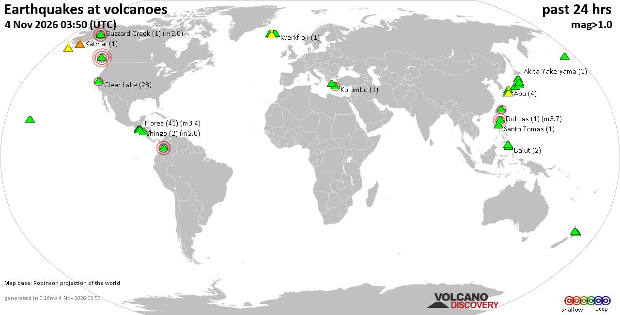
Volcano earthquake report for Wednesday, 4 November 2026World map showing volcanoes with shallow (less than 50 km) earthquakes within 20 km radius during the past 24 hours on 4 Nov 2026 Number in brackets indicate nr of quakes. Quakes detected near: Agua (1 quake mag 1.6), Akita-Yake-yama (3 quakes between mag 0.4-1.6), Apaneca Range (1 quake mag 2.1), Aso (4 quakes between mag 0.2-1.0), Balut (2 quakes between mag 1.5-1.6), Bardarbunga (1 quake mag 1.6)
Bogoslof (1 quake mag 1.8), Buzzard Creek (1 quake mag 3.0), Chingo (2 quakes between mag 2.7-2.8), Clear Lake (22 quakes between mag 0.4-2.3), Cosigüina (1 quake mag 1.9), Didicas (1 quake mag 3.7), El Hierro (1 quake mag 1.1), Flores (23 quakes between mag 1.2-3.4), Hachimantai (1 quake mag 1.3), Haku-san (1 quake mag 1.3), Hofsjökull (1 quake mag 1.9), Iriomote-jima (2 quakes between mag 0.3-2.5), Iwaki (1 quake mag 1.0), Kanaga (3 quakes between mag 0.6-1.6), Katla (1 quake mag 1.3), Katmai (1 quake mag 1.1), Kilauea (1 quake mag 1.9), Kupreanof (1 quake mag 1.7), Maroa (3 quakes between mag 1.3-1.7), Maunaloa (2 quakes between mag 1.9-2.4), Methana (1 quake mag 2.2), Numazawa (10 quakes between mag 0.5-1.3), Reporoa (2 quakes between mag 1.5-1.7), Santa Isabel (1 quake mag 3.8), Santo Tomas (1 quake mag 1.4), Tahual (1 quake mag 2.5), Te Kawa (1 quake mag 1.8), Tecuamburro (1 quake mag 1.3), Tuzo Wilson Knolls (1 quake mag 4.6), Unzen (8 quakes between mag 0.4-1.8), Zao (1 quake mag 1.1) (updated 06h50)\n\nNote: Earthquakes within 20 km from and at depths less than 50 km under active volcanoes are reported. The list is not complete because many volcanoes are not monitored and/or seismic data in high resolution is not available publicly.\n
Volcanoes with recent earthquakes above magnitude 2 or more than 10 quakes are listed below:
Apaneca Range volcano (El Salvador): magnitude 2.1 earthquakeA magnitude 2.1 earthquake occurred at the volcano 11 hours ago. The quake, which might be volcanic in origin, was located at a depth of 4.00 km depth at 1 km distance S from the volcano. Earthquake details: 2.1 quake 16 km north of Sonsonate, Departamento de Sonsonate, El Salvador, Nov 3, 2026 01:30 pm (GMT -6) (1 km S) All earthquakes at Apaneca RangeThe Apaneca Range is a chain of stratovolcanoes, lava domes and thermal areas in western El Salvador. Its dated eruptive history is uncertain, but deadly hydrothermal activity occurred at Agua Shuca in 1990, followed by another explosion there in July 2025. Buzzard Creek volcano (Eastern Alaska): magnitude 3.0 earthquakeA magnitude 3.0 earthquake occurred at the volcano 6 hours ago. The quake, which might be volcanic in origin, was located at a depth of 5.00 km depth at 19 km distance W from the volcano. Earthquake details: 3.0 quake 14 mi north of Healy, Denali Borough, Alaska, United States, Nov 3, 2026 04:13 pm (Anchorage time) (19 km W) All earthquakes at Buzzard CreekBuzzard Creek comprises two small, lake-filled volcanic craters northeast of Healy in eastern Alaska. They formed in a VEI 2 eruption dated approximately 3,000 years ago, although the stated date of 1050 BCE is uncertain. Chingo volcano (Guatemala): 2 earthquakes up to magnitude 2.82 earthquakes occurred near (under) the volcano during 6 hours, the last being recorded quake 17 hours ago. Hypocenter depths ranged between 14.40 and 6.00 km. Earthquake details: 2.8 quake 24 km south of Jutiapa, Departamento de Jutiapa, Guatemala, Nov 3, 2026 01:28 am (Guatemala time) (12 km WSW) 2.7 quake 25 km south of Jutiapa, Departamento de Jutiapa, Guatemala, Nov 3, 2026 07:28 am (GMT -6) (11 km WSW) All earthquakes at ChingoChingo is a 1,775 m stratovolcano spanning the Guatemala–El Salvador border. Its last eruption is undated, and no eruption is known from approximately the past 11,700 years. Clear Lake volcano (California): 22 earthquakes up to magnitude 2.3Possible earthquake swarm: 22 earthquakes occurred near (under) the volcano during 23 hours, the last being recorded quake 39 minutes ago. Hypocenter depths ranged between 4.68 and 0.00 km. Earthquake details: (only 5 largest) 2.3 quake Sonoma County, 14 mi southwest of Clearlake, Lake County, California, United States, Nov 3, 2026 05:53 am (GMT -8) (15 km SSW) 2.1 quake Sonoma County, 14 mi southwest of Clearlake, Lake County, California, United States, Nov 3, 2026 05:53 am (GMT -8) (15 km SSW) 1.9 quake Sonoma County, 13 mi southwest of Clearlake, Lake County, California, United States, Nov 3, 2026 12:00 am (GMT -8) (19 km S) 1.3 quake 28 mi north of Santa Rosa, Sonoma County, California, United States, Nov 3, 2026 11:49 am (GMT -8) (16 km SSW) 1.3 quake Mendocino County, 29 mi north of Santa Rosa, Sonoma County, California, United States, Nov 3, 2026 05:54 am (GMT -8) (14 km SSW) All earthquakes at Clear LakeDidicas volcano (North of Luzon): magnitude 3.7 earthquakeA magnitude 3.7 earthquake occurred at the volcano 9 hours ago. The quake, which might be volcanic in origin, was located at a depth of 11.00 km depth at 14 km distance SSW from the volcano. Earthquake details: 3.7 quake South China Sea, 24 km east of Camiguin Island, Philippines, Nov 4, 2026 05:39 am (Manila time) (14 km SSW) All earthquakes at DidicasDidicas is a volcanic island north of Luzon that became permanent during the 1952 eruption after earlier islands had been eroded away. Its last known eruption was in 1978. Flores volcano (Guatemala): 23 earthquakes up to magnitude 3.4Possible earthquake swarm: 23 earthquakes occurred near (under) the volcano during 21 hours, the last being recorded quake 3 hours ago. Hypocenter depths ranged between 15.80 and 0.00 km. Earthquake details: (only 5 largest) 3.4 quake 23 km northeast of Cuilapa, Departamento de Santa Rosa, Guatemala, Nov 3, 2026 05:29 am (Guatemala time) (14 km WNW) 3.3 quake 24 km northeast of Cuilapa, Departamento de Santa Rosa, Guatemala, Nov 3, 2026 08:55 pm (Guatemala time) (14 km WNW) 2.6 quake 24 km northeast of Cuilapa, Departamento de Santa Rosa, Guatemala, Nov 3, 2026 09:19 am (GMT -6) (15 km WNW) 2.3 quake 23 km northeast of Cuilapa, Departamento de Santa Rosa, Guatemala, Nov 3, 2026 08:06 am (Guatemala time) (15 km WNW) 2.3 quake 23 km northeast of Cuilapa, Departamento de Santa Rosa, Guatemala, Nov 3, 2026 02:06 am (GMT -6) (15 km WNW) All earthquakes at FloresFlores, also known as Volcán Amayo, is a volcanic field about 10 km west of Jutiapa in southeastern Guatemala. Its last eruption is undated, and none are known from approximately the past 11,700 years. Iriomote-jima volcano (Ryukyu Islands): 2 earthquakes up to magnitude 2.52 earthquakes occurred near (under) the volcano during 14 hours, the last being recorded quake 7 hours ago. Hypocenter depths ranged between 9.40 and 0.00 km. Earthquake details: 2.5 quake East China Sea, 20 km northeast of Iriomote Jima Island, Okinawa, Japan, Nov 3, 2026 06:32 pm (GMT +9) (10 km SSE) 0.3 quake East China Sea, 16 km northeast of Iriomote Jima Island, Okinawa, Japan, Nov 4, 2026 08:21 am (GMT +9) (19 km SSE) All earthquakes at Iriomote-jimaIriomote-jima is a shallow submarine volcano in Japan’s southern Ryukyu Islands. A major eruption in 1924 produced extensive rafts of rhyolitic pumice that reached as far north as Hokkaido. Maunaloa volcano (Hawai'i (Big Island)): 2 earthquakes up to magnitude 2.42 earthquakes occurred near (under) the volcano during 9 hours, the last being recorded quake 44 minutes ago. Hypocenter depths ranged between 38.30 and 7.21 km. Earthquake details: 2.4 quake 39 mi southwest of Hilo, Hawaii County, Hawaii, United States, Nov 3, 2026 08:06 pm (GMT -10) (6 km S) 1.9 quake 18 mi west of Volcano, Hawaii County, Hawaii, United States, Nov 3, 2026 10:50 am (GMT -10) (12 km ESE) All earthquakes at MaunaloaMaunaloa is a huge, frequently active shield volcano on Hawaiʻi’s Big Island. Its predominantly lava-producing eruptions include a well-documented episode in November–December 2022. Methana volcano (Greece): magnitude 2.2 earthquakeA magnitude 2.2 earthquake occurred at the volcano 16 hours ago. The quake, which might be volcanic in origin, was located at a depth of 10.00 km depth at 14 km distance SW from the volcano. Earthquake details: 2.2 quake Nomos Piraios, Attica, 46 km east of Argos, Argolida, Peloponnese, Greece, Nov 3, 2026 05:05 pm (GMT +2) (14 km SW) All earthquakes at MethanaMethana is a lava-dome complex forming a peninsula in Greece’s Saronic Gulf. An eruption around 258 BCE built the Kameno Vouno dome and produced a lava flow that extended about 500 m beyond the coast. Santa Isabel volcano (Colombia): magnitude 3.8 earthquakeA magnitude 3.8 earthquake occurred at the volcano 20 hours ago. The quake, which might be volcanic in origin, was located at a depth of 10.00 km depth at 7 km distance E from the volcano. Earthquake details: Reported quake or seismic-like event: Near Pereira, Risaralda Department, Colombia, Nov 3, 2026 05:57 am (GMT -5) (7 km E) All earthquakes at Santa IsabelSanta Isabel is a 4,944 m shield volcano in Colombia with a glaciated, two-peaked summit and three lava domes. Four ancient lava-producing eruptive periods are dated between approximately 5500 and 850 BCE, with no known historical eruptions. Tahual volcano (Guatemala): magnitude 2.5 earthquakeA magnitude 2.5 earthquake occurred at the volcano 21 hours ago. The quake, which might be volcanic in origin, was located at a depth of 2.00 km depth at 15 km distance WNW from the volcano. Earthquake details: 2.5 quake 15 km south of Jalapa, Departamento de Jalapa, Guatemala, Nov 3, 2026 04:18 am (GMT -6) (15 km WNW) All earthquakes at TahualTahual is an eroded, forested stratovolcano south of Monjas in Guatemala. A cone near its northeastern base produced a short basaltic lava flow during approximately the past 11,700 years, but the date of the volcano’s last eruption is unknown. Tuzo Wilson Knolls volcano (Northern Pacific Ocean): magnitude 4.6 earthquakeA magnitude 4.6 earthquake occurred at the volcano 8 hours ago. The quake, which might be volcanic in origin, was located at a depth of 3.60 km depth at 6 km distance N from the volcano. Earthquake details: 4.6 quake North Pacific Ocean, 74 km south of Kunghit Island, North Coast Regional District, British Columbia, Canada, Nov 3, 2026 02:15 pm (GMT -9) (6 km N) All earthquakes at Tuzo Wilson KnollsTuzo Wilson Knolls is a possible submarine lava dome about 1,400 m below sea level in Canada. No eruptions are known during approximately the past 12,000 years. https://www.volcanodiscovery.com/earthquakes-volcanoes/news/400343/Volcano-earthquake-report-2026-11-04.html
|
|



CMS The Best Conveyancing solicitors conveyancing quotes throughout the UK
For any webhosting enquiries please email webmaster@aus-city.com
|
|
Entire Thread
|

 Volcano earthquake report for Wednesday, 4 November 2026 |
Webmaster
|
5 hours ago
|
|
Forums60
Topics910,568
Posts945,365
Members2,960
| |
Most Online102,106
Jul 10th, 2026
|
|
|
|
|

|









































