|
|
|
0 members (),
3,366
guests, and
19
robots. |
|
Key:
Admin,
Global Mod,
Mod
|
|
S |
M |
T |
W |
T |
F |
S |
|
1
|
2
|
3
|
4
|
5
|
6
|
7
|
|
8
|
9
|
10
|
11
|
12
|
13
|
14
|
|
15
|
16
|
17
|
18
|
19
|
20
|
21
|
|
22
|
23
|
24
|
25
|
26
|
27
|
28
|
|
29
|
30
|
|
|
|
|
|
|
There are no members with birthdays on this day. |
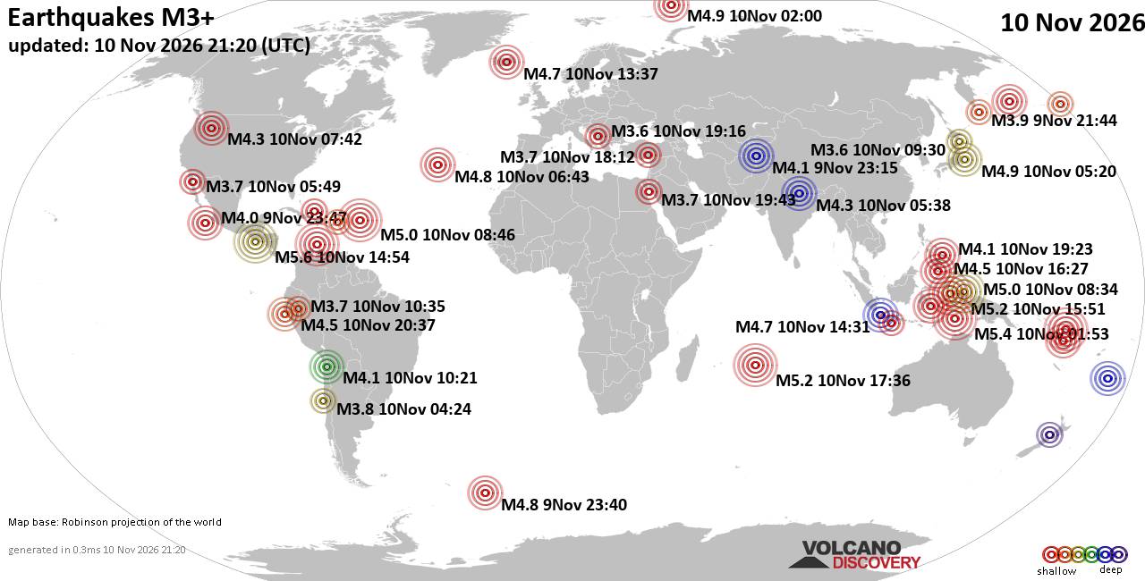
World Earthquake Report for Tuesday, 10 November 2026
• M 2.7 - 79 km W of Petrolia, CA
• M 0.9 - 11 km NNE of Campo, CA
• M 5.4 - 192 km WSW of Merizo Village, Guam
• M 0.7 - 3 km SE of Loma Linda, CA
• M 0.6 - 9 km WNW of Anza, CA
• M 0.9 - 17 km SSW of Jal, New Mexico
|

#952128
Sat 07 Nov 2026 04:50:AM
|
Joined: Feb 2001
Posts: 800,656
Launch Director
|
|
Launch Director
Joined: Feb 2001
Posts: 800,656 |
Volcano earthquake report for Saturday, 7 November 2026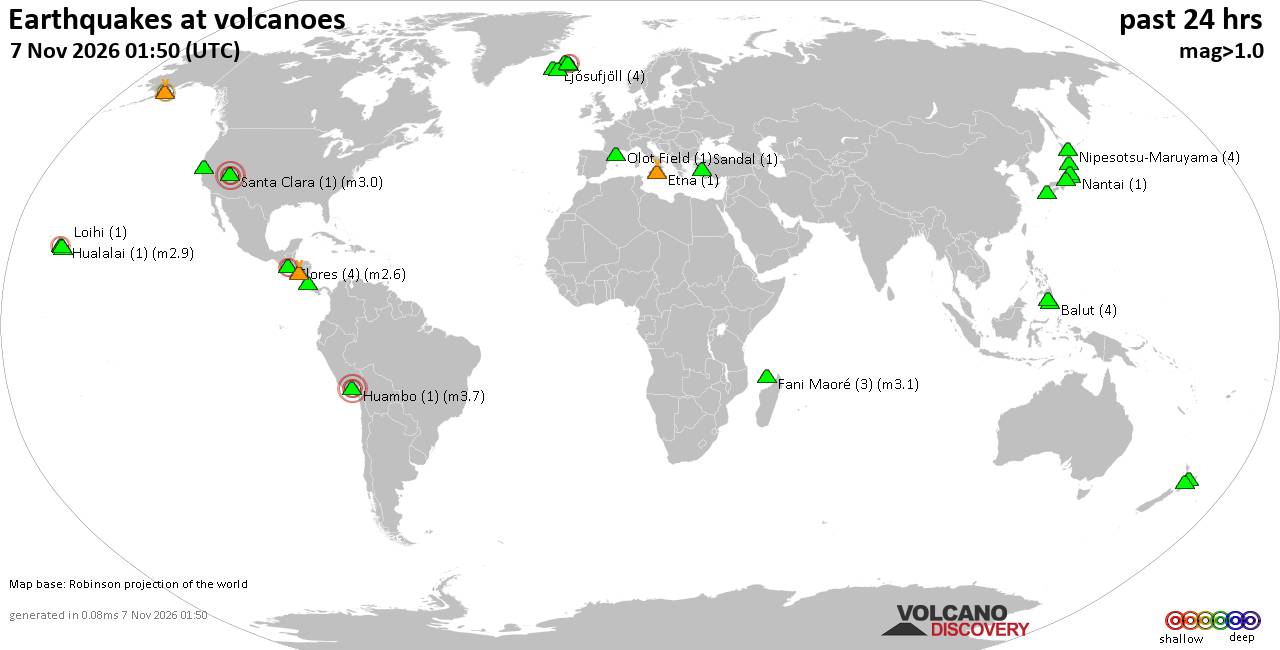 World map showing volcanoes with shallow (less than 50 km) earthquakes within 20 km radius during the past 24 hours on 7 Nov 2026 Number in brackets indicate nr of quakes. Quakes detected near: Abu (2 quakes between mag 0.7-1.6), Akita-Yake-yama (4 quakes between mag 0.6-1.5), Balut (3 quakes between mag 1.7-2.0), Barva (1 quake mag 1.0), Clear Lake (18 quakes between mag 0.2-1.3), Etna (1 quake mag 1.1)
Fani Maoré (1 quake mag 1.6), Flores (3 quakes between mag 1.5-2.6), Fourpeaked (1 quake mag 2.3), Hualalai (1 quake mag 2.9), Huambo (1 quake mag 3.7), Katmai (4 quakes between mag 0.7-2.0), Kolbeinsey Ridge (1 quake mag 1.4), Ljósufjöll (4 quakes between mag 0.0-1.4), Loihi (1 quake mag 1.7), Maroa (1 quake mag 1.9), Maunaloa (2 quakes between mag 1.6-1.9), Nantai (1 quake mag 1.0), Nipesotsu-Maruyama (4 quakes between mag 0.1-1.6), Numazawa (4 quakes between mag 0.7-1.2), Olot Field (1 quake mag 1.5), Ontake-san (3 quakes between mag 0.1-1.3), Parker (1 quake mag 1.5), Prestahnukur (1 quake mag 1.1), Sandal (1 quake mag 1.0), Telica (2 quakes between mag 1.2-1.8), Theistareykjarbunga (1 quake mag 1.2), Tjörnes Fracture Zone (6 quakes between mag 0.0-2.1), Unzen (2 quakes between mag 0.8-1.4) (updated 04h50)\n\nNote: Earthquakes within 20 km from and at depths less than 50 km under active volcanoes are reported. The list is not complete because many volcanoes are not monitored and/or seismic data in high resolution is not available publicly.\n
Volcanoes with recent earthquakes above magnitude 2 or more than 10 quakes are listed below:
Clear Lake volcano (California): 18 earthquakes up to magnitude 1.3Possible earthquake swarm: 18 earthquakes occurred near (under) the volcano during 22 hours, the last being recorded quake 1 hour 44 minutes ago. Hypocenter depths ranged between 13.52 and 1.38 km. Earthquake details: (only 5 largest) 1.3 quake Lake County, 28 mi north of Santa Rosa, Sonoma County, California, United States, Nov 6, 2026 09:47 am (GMT -8) (15 km S) 1.3 quake 27 mi north of Santa Rosa, Sonoma County, California, United States, Nov 6, 2026 09:47 am (GMT -8) (17 km SSW) 1.1 quake Lake County, 27 mi north of Windsor, Sonoma County, California, United States, Nov 6, 2026 10:10 am (GMT -8) (16 km WSW) 1.1 quake Lake County, 28 mi north of Santa Rosa, Sonoma County, California, United States, Nov 6, 2026 09:45 am (GMT -8) (15 km S) 1.0 quake Lake County, 28 mi north of Santa Rosa, Sonoma County, California, United States, Nov 6, 2026 02:51 pm (GMT -8) (15 km S) All earthquakes at Clear LakeFlores volcano (Guatemala): 3 earthquakes up to magnitude 2.63 earthquakes occurred near (under) the volcano during 12 hours, the last being recorded quake 10 hours ago. Hypocenter depths ranged between 5.00 and 5.00 km. Earthquake details: 2.6 quake 24 km west of Jutiapa, Departamento de Jutiapa, Guatemala, Nov 6, 2026 12:33 pm (GMT -6) (13 km WNW) 2.4 quake 24 km northeast of Cuilapa, Departamento de Santa Rosa, Guatemala, Nov 6, 2026 10:41 am (GMT -6) (14 km WNW) 1.5 quake 23 km northeast of Cuilapa, Departamento de Santa Rosa, Guatemala, Nov 6, 2026 12:30 am (GMT -6) (15 km WNW) All earthquakes at FloresFlores, also known as Volcán Amayo, is a volcanic field about 10 km west of Jutiapa in southeastern Guatemala. Its last eruption is undated, and none are known from approximately the past 11,700 years. Fourpeaked volcano (Alaska Peninsula): magnitude 2.3 earthquakeA magnitude 2.3 earthquake occurred at the volcano 1 hour 37 minutes ago. The quake, which might be volcanic in origin, was located at a depth of 0.80 km depth at 3 km distance NNE from the volcano. Earthquake details: 2.3 quake Kenai Peninsula Borough, 83 mi northwest of Kodiak, Kodiak Island Borough, Alaska, United States, Nov 6, 2026 06:12 pm (GMT -9) (3 km NNE) All earthquakes at FourpeakedFourpeaked is a glacier-covered Alaskan stratovolcano whose first confirmed historical eruption occurred in September 2006. A 1-km-long summit fissure produced a phreatic eruption and minor ashfall, followed by unrest into 2007. Hualalai volcano (Hawai'i (Big Island)): magnitude 2.9 earthquakeA magnitude 2.9 earthquake occurred at the volcano 7 hours ago. The quake, which might be volcanic in origin, was located at a depth of 13.91 km depth at 10 km distance NW from the volcano. Earthquake details: 2.9 quake 3.2 mi northeast of Kalaoa, Hawaii County, Hawaii, United States, Nov 6, 2026 12:08 pm (Honolulu time) (10 km NW) All earthquakes at HualalaiHuambo volcano (Peru): magnitude 3.7 earthquakeA magnitude 3.7 earthquake occurred at the volcano 11 hours ago. The quake, which might be volcanic in origin, was located at a depth of 12.00 km depth at 6 km distance N from the volcano. Earthquake details: 3.7 quake 95 km northwest of Arequipa, Arequipa, Peru, Nov 6, 2026 01:07 pm (Lima time) (6 km N) All earthquakes at HuamboHuambo is a two-part volcanic field in Peru. Its only confirmed dated eruption occurred at Cerro Keyocc around 700 BCE, producing explosive activity, scoria and lava flows. Tjörnes Fracture Zone volcano (Iceland): 6 earthquakes up to magnitude 2.16 earthquakes occurred near (under) the volcano during 11 hours, the last being recorded quake 46 minutes ago. Hypocenter depths ranged between 9.60 and 5.10 km. Earthquake details: (only 5 largest) 2.1 quake 11.0 km WNW of Kópasker Nov 6, 2026 04:58 pm (Reykjavik time) (19 km E) 1.7 quake Iceland: 11.7 km WSW of Kópasker Nov 7, 2026 01:39 am (Reykjavik time) (19 km ESE) 1.3 quake Iceland: 14.7 km WSW of Kópasker Nov 7, 2026 04:04 am (Reykjavik time) (18 km ESE) 0.9 quake Iceland: 11.2 km W of Kópasker Nov 7, 2026 03:20 am (Reykjavik time) (19 km E) 0.7 quake Iceland: 10.8 km W of Kópasker Nov 7, 2026 12:50 am (Reykjavik time) (19 km E) All earthquakes at Tjörnes Fracture ZoneThe Tjörnes Fracture Zone is an offshore volcanic system north of Iceland. A poorly documented submarine eruption was reported near Manareyjar Island in 1867–1868. https://www.volcanodiscovery.com/earthquakes-volcanoes/news/403516/Volcano-earthquake-report-2026-11-07.html
|
|



CMS The Best Conveyancing solicitors conveyancing quotes throughout the UK
For any webhosting enquiries please email webmaster@aus-city.com
|
|
Entire Thread
|
 Volcano earthquake report for Saturday, 7 November 2026 |
Webmaster
|
Sat 07 Nov 2026 04:50:AM
|
|
Forums60
Topics921,131
Posts955,928
Members2,960
| |
Most Online102,106
Jul 10th, 2026
|
|
|
|
|

|









































