|
|
|
0 members (),
3,669
guests, and
19
robots. |
|
Key:
Admin,
Global Mod,
Mod
|
|
S |
M |
T |
W |
T |
F |
S |
|
1
|
2
|
3
|
4
|
5
|
6
|
7
|
|
8
|
9
|
10
|
11
|
12
|
13
|
14
|
|
15
|
16
|
17
|
18
|
19
|
20
|
21
|
|
22
|
23
|
24
|
25
|
26
|
27
|
28
|
|
29
|
30
|
|
|
|
|
|
|
There are no members with birthdays on this day. |
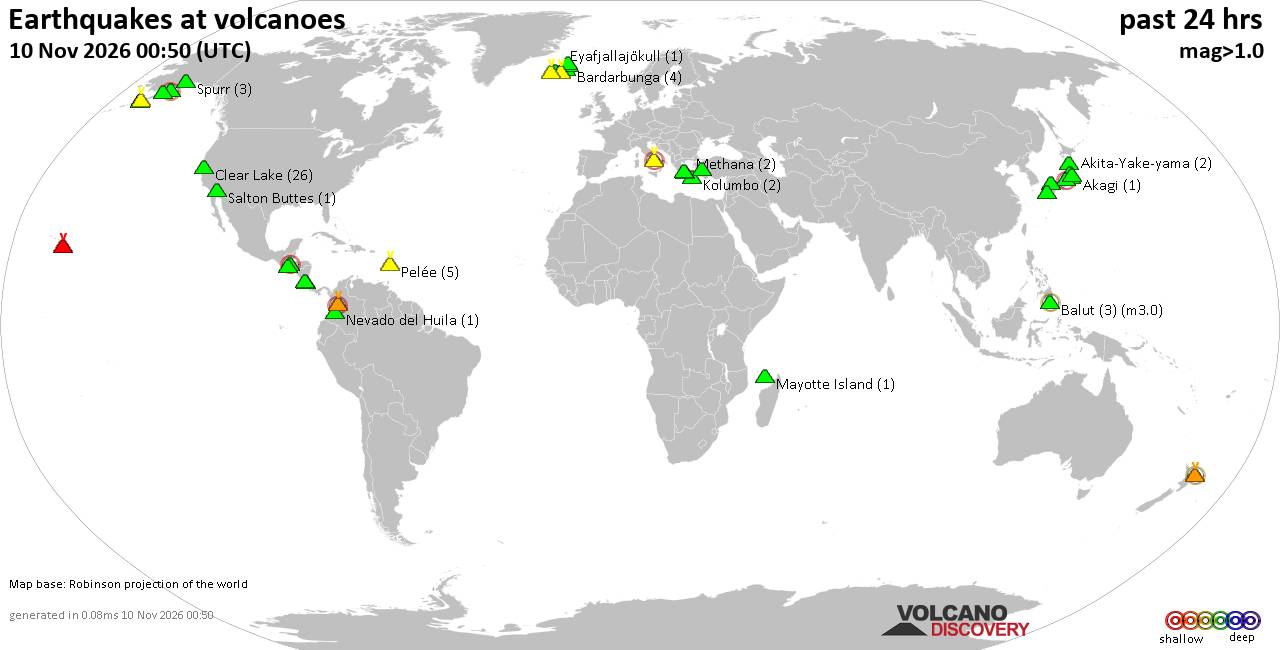
Volcano earthquake report for Tuesday, 10 November 2026
• M -0.6 - 63 km ENE of Pedro Bay, Alaska
• M 0.6 - 47 km ENE of Adak, Alaska
• M 2.3 - 54 km ENE of Susitna North, Alaska
• M 1.4 - 60 km WNW of Nikiski, Alaska
• M 1.1 - 109 km S of McCarthy, Alaska
|

#953611
Sun 08 Nov 2026 09:50:AM
|
Joined: Feb 2001
Posts: 800,656
Launch Director
|
|
Launch Director
Joined: Feb 2001
Posts: 800,656 |
Volcano earthquake report for Sunday, 8 November 2026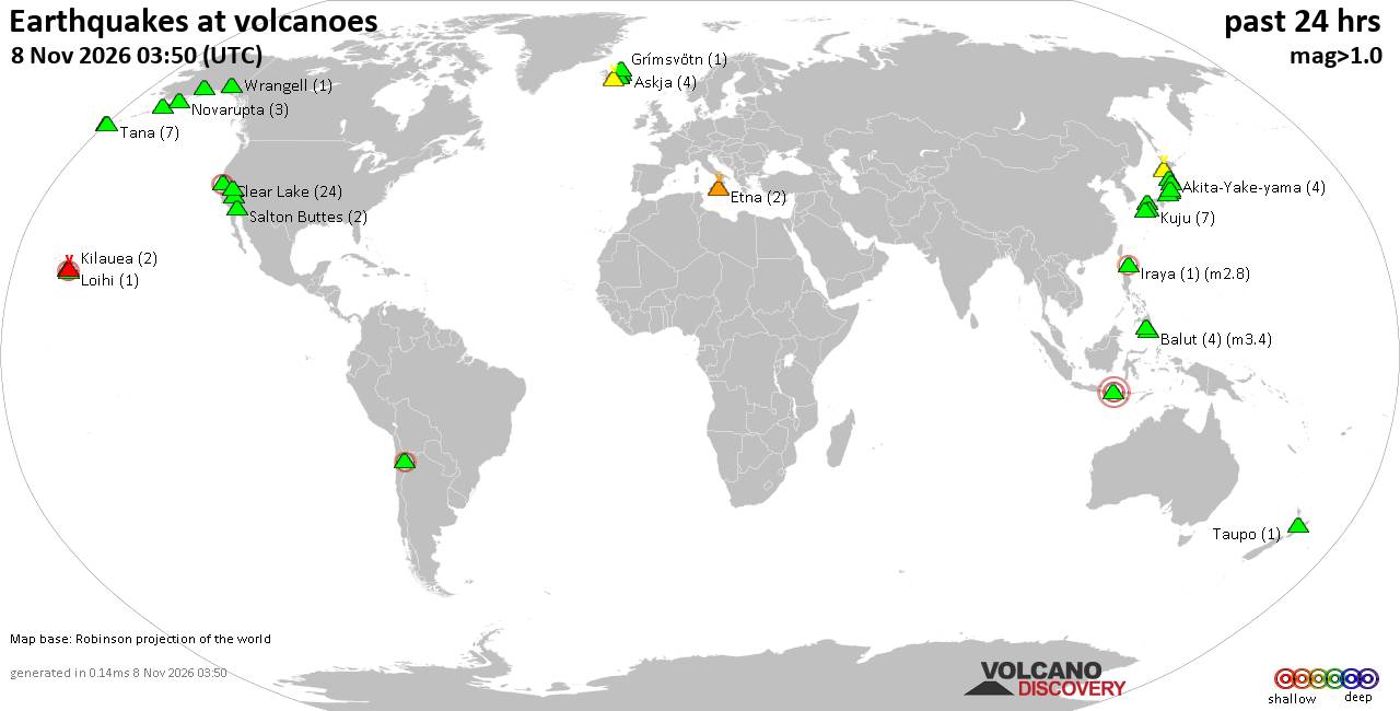 World map showing volcanoes with shallow (less than 50 km) earthquakes within 20 km radius during the past 24 hours on 8 Nov 2026 Number in brackets indicate nr of quakes. Quakes detected near: Abu (2 quakes between mag 0.3-1.0), Aniakchak (1 quake mag 1.7), Balut (4 quakes between mag 1.6-3.4), Bardarbunga (2 quakes between mag 0.5-1.8), Brennisteinsfjöll (8 quakes between mag 0.2-1.5), Churchill (1 quake mag 1.4)
Clear Lake (27 quakes between mag 0.2-2.0), Cleveland (1 quake mag 1.4), Colli Albani (1 quake mag 1.4), Coso (1 quake mag 1.0), Etna (2 quakes between mag 0.7-1.5), Grímsvötn (1 quake mag 2.0), Iraya (1 quake mag 2.8), Katla (1 quake mag 1.4), Kilauea (2 quakes between mag 2.0-2.3), Komaga-take (1 quake mag 2.9), Kusatsu-Shirane (1 quake mag 1.2), Leonard Range (1 quake mag 1.7), Loihi (1 quake mag 1.9), Mammoth Mountain (3 quakes between mag 0.6-1.4), Maunaloa (2 quakes between mag 2.0-2.9), Novarupta (2 quakes between mag 0.8-1.2), Numazawa (7 quakes between mag 0.3-1.1), Prestahnukur (1 quake mag 1.2), Pular (1 quake mag 2.8), Rinjani (1 quake mag 3.0), Tana (2 quakes between mag 1.2-1.5), Taupo (1 quake mag 1.1), Telong (1 quake mag 2.3), Tjörnes Fracture Zone (5 quakes between mag 1.0-1.9), Unzen (1 quake mag 1.2), Wrangell (1 quake mag 1.7) (updated 09h50)\n\nNote: Earthquakes within 20 km from and at depths less than 50 km under active volcanoes are reported. The list is not complete because many volcanoes are not monitored and/or seismic data in high resolution is not available publicly.\n
Volcanoes with recent earthquakes above magnitude 2 or more than 10 quakes are listed below:
Balut volcano (Mindanao): 4 earthquakes up to magnitude 3.44 earthquakes occurred near (under) the volcano during 15 hours, the last being recorded quake 4 hours ago. Hypocenter depths ranged between 33.00 and 4.00 km. Earthquake details: 3.4 quake Philippine Sea, 4.5 km northwest of Sarangani Island, Philippines, Nov 7, 2026 11:05 pm (Manila time) (10 km NE) 2.4 quake Philippine Sea, 14 km northwest of Sarangani Island, Philippines, Nov 8, 2026 04:49 am (Manila time) (16 km N) 1.7 quake Celebes Sea, 27 km southwest of Sarangani Island, Philippines, Nov 8, 2026 05:20 am (Manila time) (15 km SW) 1.6 quake Province of Davao del Sur, 4.9 km west of Sarangani, Philippines, Nov 8, 2026 02:11 pm (Manila time) (5 km E) All earthquakes at BalutBalut is an 840 m island stratovolcano south of Mindanao whose last known eruption occurred between about 2 million and 11,700 years ago. Hot springs and thermally altered ground occur on its western and southwestern flanks. Clear Lake volcano (California): 27 earthquakes up to magnitude 2.0Possible earthquake swarm: 27 earthquakes occurred near (under) the volcano during 22 hours, the last being recorded quake 1 hour 40 minutes ago. Hypocenter depths ranged between 7.10 and 0.75 km. Earthquake details: (only 5 largest) 2.0 quake Sonoma County, 14 mi southwest of Clearlake, Lake County, California, United States, Nov 7, 2026 05:47 pm (GMT -8) (18 km SSW) 1.3 quake 27 mi north of Santa Rosa, Sonoma County, California, United States, Nov 7, 2026 01:19 pm (GMT -8) (17 km S) 1.3 quake 28 mi north of Santa Rosa, Sonoma County, California, United States, Nov 7, 2026 05:15 am (GMT -8) (15 km SSW) 1.1 quake Lake County, 27 mi north of Santa Rosa, Sonoma County, California, United States, Nov 7, 2026 05:33 pm (GMT -8) (15 km S) 1.1 quake Lake County, 28 mi north of Santa Rosa, Sonoma County, California, United States, Nov 7, 2026 03:51 pm (GMT -8) (15 km S) All earthquakes at Clear LakeIraya volcano (North of Luzon): magnitude 2.8 earthquakeA magnitude 2.8 earthquake occurred at the volcano 17 hours ago. The quake, which might be volcanic in origin, was located at a depth of 16.00 km depth at 6 km distance W from the volcano. Earthquake details: 2.8 quake South China Sea, 6.6 km north of Batan Island, Philippines, Nov 8, 2026 01:12 am (Manila time) (6 km W) All earthquakes at IrayaKilauea volcano (Hawai'i (Big Island)): 2 earthquakes up to magnitude 2.32 earthquakes occurred near (under) the volcano during 3 hours, the last being recorded quake 10 hours ago. Hypocenter depths ranged between 29.86 and 7.01 km. Earthquake details: 2.3 quake 32 mi southwest of Hilo, Hawaii County, Hawaii, United States, Nov 7, 2026 01:53 pm (GMT -10) (14 km WSW) 2.0 quake 35 mi southwest of Hilo, Hawaii County, Hawaii, United States, Nov 7, 2026 11:04 am (GMT -10) (17 km SSW) All earthquakes at KilaueaKomaga-take volcano (Hokkaido): magnitude 2.9 earthquakeA magnitude 2.9 earthquake occurred at the volcano 16 hours ago. The quake, which might be volcanic in origin, was located at a depth of 11.50 km depth at 15 km distance SSW from the volcano. Earthquake details: 2.9 quake 6 km northwest of Honcho, Hokkaido, Japan, Nov 8, 2026 02:31 am (GMT +9) (15 km SSW) All earthquakes at Komaga-takeKomaga-take is an explosive stratovolcano in southern Hokkaido. A major eruption and collapse in 1640 generated a deadly tsunami, and smaller eruptions were recorded as recently as 2000. Maunaloa volcano (Hawai'i (Big Island)): 2 earthquakes up to magnitude 2.92 earthquakes occurred near (under) the volcano during 19 hours, the last being recorded quake 35 minutes ago. Hypocenter depths ranged between 48.84 and 0.83 km. Earthquake details: 2.9 quake 29 mi southwest of Hilo, Hawaii County, Hawaii, United States, Nov 7, 2026 11:14 pm (Honolulu time) (17 km E) 2.0 quake 39 mi southwest of Hilo, Hawaii County, Hawaii, United States, Nov 7, 2026 04:43 am (GMT -10) (4 km S) All earthquakes at MaunaloaMaunaloa is a huge, frequently active shield volcano on Hawaiʻi’s Big Island. Its predominantly lava-producing eruptions include a well-documented episode in November–December 2022. Pular volcano (Northern Chile, Bolivia and Argentina): magnitude 2.8 earthquakeA magnitude 2.8 earthquake occurred at the volcano 7 hours ago. The quake, which might be volcanic in origin, was located at a depth of 23.10 km depth at 12 km distance SSE from the volcano. Earthquake details: 2.8 quake Provincia de El Loa, 255 km east of Antofagasta, Provincia de Antofagasta, Region de Antofagasta, Chile, Nov 7, 2026 11:33 pm (GMT -3) (12 km SSE) All earthquakes at PularPular is a high Chilean stratovolcano forming part of a 12 km ridge with Cerro Pajonales. Its only reported historical eruption, in April 1990, remains uncertain and may not have occurred. Rinjani volcano (Lombok): magnitude 3.0 earthquakeA magnitude 3.0 earthquake occurred at the volcano 24 hours ago. The quake, which might be volcanic in origin, was located at a depth of 10.00 km depth at 9 km distance NE from the volcano. Earthquake details: 3.0 quake 31 km north of Selong, Kabupaten Lombok Timur, West Nusa Tenggara, Indonesia, Nov 7, 2026 10:05 am (GMT +0) (9 km NE) All earthquakes at RinjaniRinjani is a 3,726-m stratovolcano on Lombok whose large caldera formed during the enormous 1257 eruption of Samalas. Recorded activity since the mid-19th century has occurred at Barujari cone within the caldera. Telong volcano (Sumatra): magnitude 2.3 earthquakeA magnitude 2.3 earthquake occurred at the volcano 44 minutes ago. The quake, which might be volcanic in origin, was located at a depth of 13.00 km depth at 3 km distance SW from the volcano. Earthquake details: 2.3 quake Kabupaten Bener Meriah, 52 km south of Bireun, Indonesia, Nov 8, 2026 04:06 pm (GMT +7) (3 km SW) All earthquakes at TelongTelong is a 2,617 m stratovolcano in northern Sumatra with five confirmed eruptive periods between 1837 and 1937. Earthquake unrest in 2025-26 prompted raised alert levels and temporary evacuations, without a reported eruption. https://www.volcanodiscovery.com/earthquakes-volcanoes/news/404101/Volcano-earthquake-report-2026-11-08.html
|
|



CMS The Best Conveyancing solicitors conveyancing quotes throughout the UK
For any webhosting enquiries please email webmaster@aus-city.com
|
|
Entire Thread
|
 Volcano earthquake report for Sunday, 8 November 2026 |
Webmaster
|
Sun 08 Nov 2026 09:50:AM
|
|
Forums60
Topics919,598
Posts954,395
Members2,960
| |
Most Online102,106
Jul 10th, 2026
|
|
|
|
|

|









































