|
0 members (),
3,839
guests, and
24
robots. |
|
Key:
Admin,
Global Mod,
Mod
|
|
S |
M |
T |
W |
T |
F |
S |
|
1
|
2
|
3
|
4
|
5
|
6
|
7
|
|
8
|
9
|
10
|
11
|
12
|
13
|
14
|
|
15
|
16
|
17
|
18
|
19
|
20
|
21
|
|
22
|
23
|
24
|
25
|
26
|
27
|
28
|
|
29
|
30
|
|
|
|
|
|
|
There are no members with birthdays on this day. |
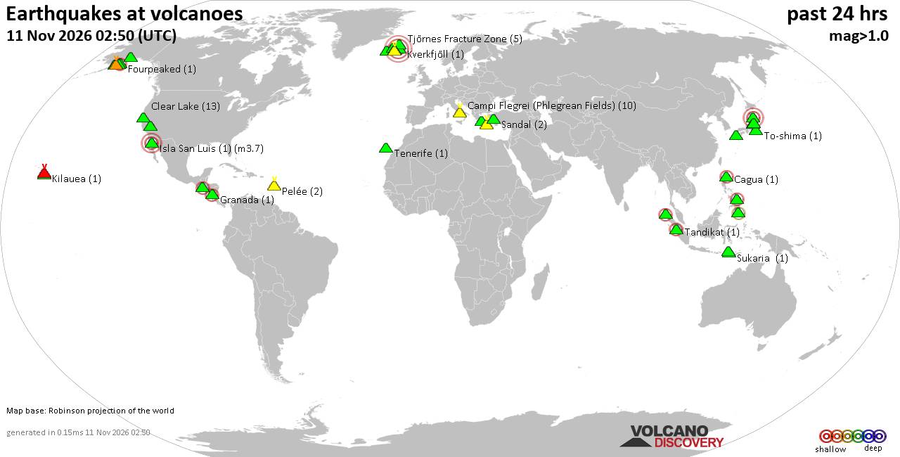
Volcano earthquake report for Wednesday, 11 November 2026
• Moderate, deep magnitude-5.4 earthquake reported 28 km southwest of Calama,...
• M 0.6 - 14 km ENE of Ridgecrest, CA
• Moderate magnitude 4.7 earthquake 89 km west of Saumlaki, Indonesia
• M 0.8 - 65 km WNW of Tyonek, Alaska
• Strong mag. 5.4 earthquake - Provincia de Tocopilla, 28 km west of Calama, ...
|
|
|
Joined: Feb 2001
Posts: 800,656
Launch Director
|
|
Launch Director
Joined: Feb 2001
Posts: 800,656 |
SPC Nov 11, 2026 0600 UTC Day 1 Convective OutlookSPC 1200Z Day 1 Outlook 
Day 1 Convective Outlook
NWS Storm Prediction Center Norman OK
1151 PM CST Tue Nov 10 2026

Valid 111200Z - 121200Z

...THERE IS A MARGINAL RISK OF SEVERE THUNDERSTORMS ACROSS PARTS OF
THE OHIO AND WESTERN TENNESSEE VALLEYS...

...SUMMARY...
Thunderstorms capable of isolated large hail, damaging wind gusts,
and perhaps a tornado will be possible Wednesday afternoon and
evening across parts of the Ohio and western Tennessee Valleys.

...Synopsis...

A lead short-wave trough will move through portions of the southern
Great Lakes and OH Valley on Wednesday, ahead of a stronger upstream
system and attending mid/upper-level wind maxima, which will
progress through the mid-MO and mid-MS Valleys into the Mid-South/TN
Valley. The net result will be a broad zone of height falls/forcing
for ascent overspreading the OH and TN Valleys Wednesday afternoon
into night. In the low levels, a cyclone will track from eastern IA
at 12Z Wednesday through central IL and IN during the afternoon
before reaching the upper OH Valley late Wednesday night. Meanwhile,
a trailing cold front will advance southeast through the mid-MS,
much of the OH, and TN Valleys during the forecast period.


...Ohio Valley into the Mid-South and Tennessee Valley...

00Z observed soundings and current surface observations indicate the
presence of a partially modified continental-polar air mass in place
over the southern Plains into Ozark Plateau, characterized by
boundary-layer dewpoints in the 50s and lowest 100-mb mean-mixing
ratios of 9-10.5 g/kg. That moisture will be advected into the
region on Wednesday ahead of the front and beneath a plume of
modestly steep mid-level lapse rates (e.g., 7-7.5 C/km), yielding a
relatively narrow axis of MLCAPE of 750-1250 J/kg by mid-late
afternoon.

Divergence aloft in the exit region of the upper-level jet streak
will enhance convergence in the vicinity of the surface low and
trailing front, resulting in a gradual increase in storm coverage
and intensity through the afternoon, initially from northern and
eastern IL into IN. Subsequent storm development is anticipated by
late afternoon into evening from portions of western and central KY
into middle TN, though storm coverage is likely to decrease with
southward extent.

The presence of 35-40 kt of effective bulk shear with a vector
orientation largely perpendicular to the surface front should favor
semi-discrete storm modes, which is consistent with several REFS
ensemble members. The somewhat marginal CAPE-shear parameter space
may limit the potential for sustained supercells, and an associated
greater severe weather threat. Nonetheless, the relatively steep
low/midlevel lapse rates with 500-mb temperatures approaching -20 C
will be supportive of isolated occurrences of large hail and
damaging winds, especially with any transient supercell structures
and/or bowing line segment. A tornado is possible during the late
afternoon or early evening as low-level shear strengthens. However,
convective inhibition is expected to increase fairly quickly during
the evening, suggesting any threat will be short-lived.


...Central and Southern Florida...

A moist and moderately unstable air mass (e.g., MLCAPE of 1000-1500
J/kg) is forecast to the south of a weak west-to-east oriented
surface boundary/confluence zone over the central peninsula. Aided
by the glancing influence of a weak disturbance passing to the
north, thunderstorms should increase in areal coverage through the
afternoon, especially from the south-central peninsula toward the
Atlantic Coast. The presence of 35-40 kt of deep-layer shear may
foster a few stronger storms capable of hail and/or outflow winds
approaching severe levels.

..Mead.. 11/11/2026
Read morehttps://www.spc.noaa.gov/products/outlook/day1otlk_1200.html
|
|



CMS The Best Conveyancing solicitors conveyancing quotes throughout the UK
For any webhosting enquiries please email webmaster@aus-city.com
|
|
Entire Thread
|

 SPC Nov 11, 2026 0600 UTC Day 1 Convective Outlook |
Webmaster
|
6 hours ago
|
|
Forums60
Topics921,923
Posts956,720
Members2,960
| |
Most Online102,106
Jul 10th, 2026
|
|
|









































