|
0 members (),
2,416
guests, and
26
robots. |
|
Key:
Admin,
Global Mod,
Mod
|
|
S |
M |
T |
W |
T |
F |
S |
|
1
|
2
|
3
|
4
|
5
|
6
|
7
|
|
8
|
9
|
10
|
11
|
12
|
13
|
14
|
|
15
|
16
|
17
|
18
|
19
|
20
|
21
|
|
22
|
23
|
24
|
25
|
26
|
27
|
28
|
|
29
|
30
|
|
|
|
|
|
|
There are no members with birthdays on this day. |
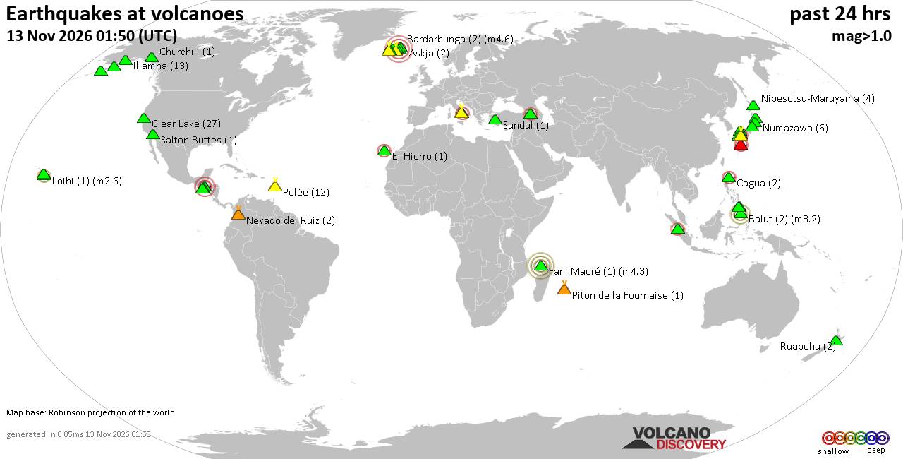
Volcano earthquake report for Friday, 13 November 2026
• M 3.4 - 54 km N of Kobuk, Alaska
• Moderate mag. 4.9 earthquake - Northern Mariana Islands: Mariana Islands on...
• M 1.6 - 28 km WSW of Salamatof, Alaska
• M -0.7 - 66 km ENE of Pedro Bay, Alaska
• M 0.6 - 89 km SE of Kokhanok, Alaska
• M 0.7 - 90 km SE of Kokhanok, Alaska
|

#958510
Wed 11 Nov 2026 08:36:AM
|
Joined: Feb 2001
Posts: 800,656
Launch Director
|
|
Launch Director
Joined: Feb 2001
Posts: 800,656 |
Issued at 1100 PM HST Tue Nov 10 2026 571
WTPA44 PHFO 110836
TCDCP4
Tropical Storm Pena Discussion Number 19
NWS Central Pacific Hurricane Center Honolulu HI CP042026
Issued by NWS National Hurricane Center Miami FL
1100 PM HST Tue Nov 10 2026
Convection continues to wax and wane near Pena, with most of the
current activity well north of the center. A WSFM microwave pass
and a SAR pass from a few hours ago showed the system was moving
south of west, and all of the tropical-storm-force winds were
north of the center. The current intensity is kept at 40 kt,
consistent with the SAR data and just above a recently received
ASCAT scatterometer pass.
Pena's motion is estimated to be 260/8 kt. The cyclone continues to
be steered by a high pressure ridge centered over the subtropical
Central Pacific, and the high should cause the storm to accelerate
westward during the next few days. The most notable change is that
the guidance has shifted slightly to the south, probably because
the storm is still losing latitude. The new NHC track forecast is
nudged in that direction, close to a blend of the Google DeepMind
ensemble and the HFIP Corrected Consensus models.
Despite the storm being over very warm waters with decent mid-level
humidity values, there is some westerly shear noted below the
outflow layer because of stronger low-level flow and weak mid-
to upper-level flow. The environment is not expected to change much
during the next few days, but a small increase in shear and
decrease in moisture is noted by Thursday. This should be enough
to cause weakening by then, and the system could dissipate in a few
days while it is near the International Dateline due to a
persistence of these unfavorable conditions, or an increase in
forward speed that causes the weak cyclone to open up into a
trough. The intensity forecast is reduced slightly from the last
one, and the dissipation time has been brought forward, similar to
the latest global model consensus solution.
FORECAST POSITIONS AND MAX WINDS
INIT 11/0900Z 10.1N 166.7W 40 KT 45 MPH
12H 11/1800Z 10.0N 168.4W 40 KT 45 MPH
24H 12/0600Z 10.2N 171.2W 40 KT 45 MPH
36H 12/1800Z 10.6N 174.3W 35 KT 40 MPH
48H 13/0600Z 11.0N 177.4W 35 KT 40 MPH
60H 13/1800Z 11.4N 179.5E 30 KT 35 MPH
72H 14/0600Z...DISSIPATED
$$
Forecaster Blake Source: Tropical Storm Pena Forecast Discussion Number 19
|
|



CMS The Best Conveyancing solicitors conveyancing quotes throughout the UK
For any webhosting enquiries please email webmaster@aus-city.com
|
|
Entire Thread
|
 Tropical Storm Pena Forecast Discussion Number 19 |
Webmaster
|
Wed 11 Nov 2026 08:36:AM
|
|
Forums60
Topics925,284
Posts960,081
Members2,960
| |
Most Online102,106
Jul 10th, 2026
|
|
|









































