|
|
|
0 members (),
3,956
guests, and
23
robots. |
|
Key:
Admin,
Global Mod,
Mod
|
|
S |
M |
T |
W |
T |
F |
S |
|
1
|
2
|
3
|
4
|
5
|
6
|
7
|
|
8
|
9
|
10
|
11
|
12
|
13
|
14
|
|
15
|
16
|
17
|
18
|
19
|
20
|
21
|
|
22
|
23
|
24
|
25
|
26
|
27
|
28
|
|
29
|
30
|
|
|
|
|
|
|
There are no members with birthdays on this day. |
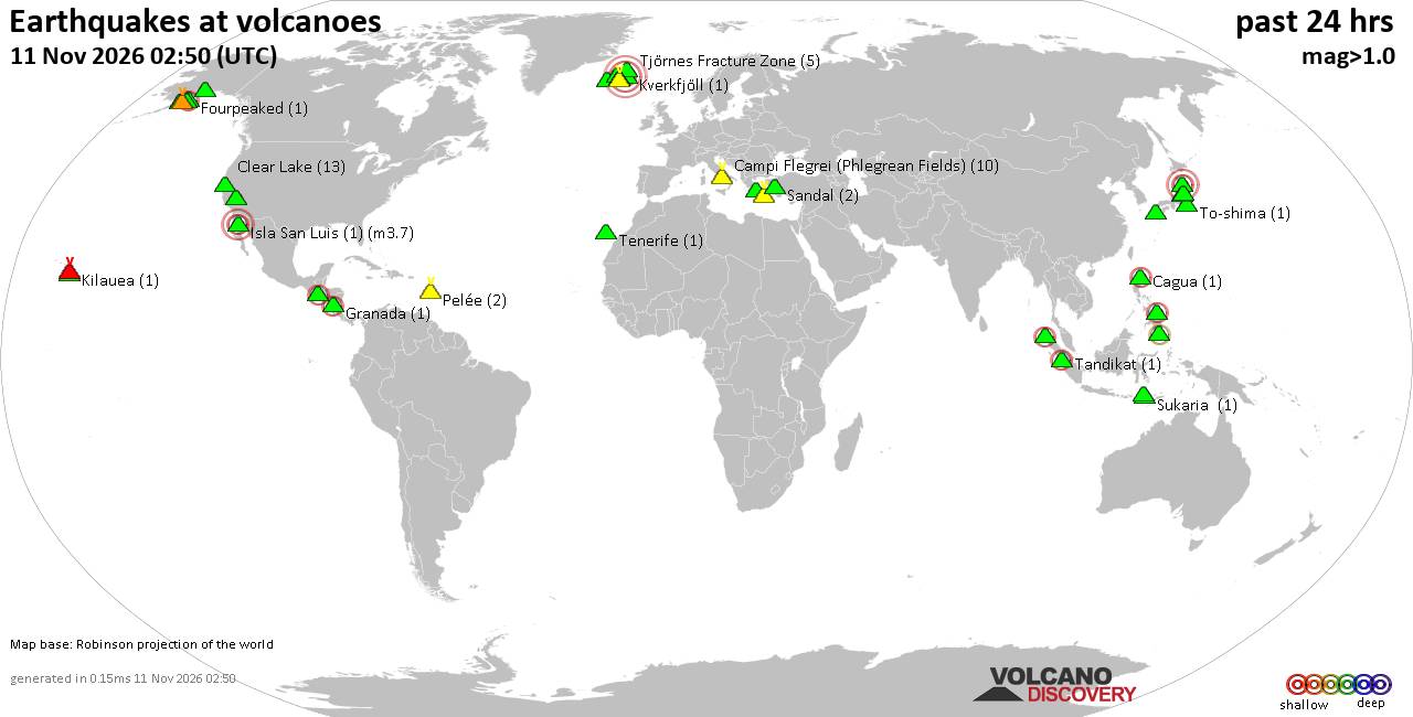
Volcano earthquake report for Wednesday, 11 November 2026
• Moderate, deep magnitude-5.4 earthquake reported 28 km southwest of Calama,...
• M 0.6 - 14 km ENE of Ridgecrest, CA
• Moderate magnitude 4.7 earthquake 89 km west of Saumlaki, Indonesia
• M 0.8 - 65 km WNW of Tyonek, Alaska
• Strong mag. 5.4 earthquake - Provincia de Tocopilla, 28 km west of Calama, ...
|
|
|
Joined: Feb 2001
Posts: 800,656
Launch Director
|
|
Launch Director
Joined: Feb 2001
Posts: 800,656 |
Volcano earthquake report for Wednesday, 11 November 2026World map showing volcanoes with shallow (less than 50 km) earthquakes within 20 km radius during the past 24 hours on 11 Nov 2026 Number in brackets indicate nr of quakes. Quakes detected near: Aso (7 quakes between mag 0.1-2.6), Balut (2 quakes between mag 2.0-2.3), Bardarbunga (4 quakes between mag 0.5-4.7), Baru (1 quake mag 2.4), Chingo (1 quake mag 2.5), Clear Lake (11 quakes between mag 0.5-1.3)
Eldey (13 quakes between mag 0.7-1.6), Flores (5 quakes between mag 1.9-3.6), Fourpeaked (1 quake mag 2.0), Kaguyak (1 quake mag 1.6), Katmai (1 quake mag 1.0), Kuju (16 quakes between mag 0.1-1.6), Kurikoma (5 quakes between mag 0.3-3.0), Kverkfjöll (1 quake mag 1.2), Mageik (1 quake mag 1.1), Makaturing (1 quake mag 1.5), Martin (1 quake mag 1.1), Methana (1 quake mag 1.4), Narugo (1 quake mag 1.4), Nikko-Shirane (5 quakes between mag 0.1-1.7), Paluweh (1 quake mag 1.8), Pelée (2 quakes between mag 0.8-1.0), Prestahnukur (1 quake mag 1.8), Ruapehu (1 quake mag 1.4), Sandal (1 quake mag 1.1), Santorini (1 quake mag 1.6), Spurr (5 quakes between mag 0.8-1.7), Sukaria (1 quake mag 1.9), Tandikat (1 quake mag 2.2), Taupo (1 quake mag 1.0), Tenerife (1 quake mag 1.4), To-shima (1 quake mag 1.8), Torfajökull (5 quakes between mag 0.4-1.5), Unzen (8 quakes between mag 0.1-1.3) (updated 11h50)\n\nNote: Earthquakes within 20 km from and at depths less than 50 km under active volcanoes are reported. The list is not complete because many volcanoes are not monitored and/or seismic data in high resolution is not available publicly.\n
Volcanoes with recent earthquakes above magnitude 2 or more than 10 quakes are listed below:
Aso volcano (Kyushu): 7 earthquakes up to magnitude 2.67 earthquakes occurred near (under) the volcano during 7 hours, the last being recorded quake 4 hours ago. Hypocenter depths ranged between 9.30 and 6.30 km. Earthquake details: (only 5 largest) 2.6 quake 7.9 km north of Aso, Kumamoto, Japan, Nov 11, 2026 03:21 pm (GMT +9) (13 km N) 1.3 quake 7.5 km north of Aso, Kumamoto, Japan, Nov 11, 2026 05:08 pm (GMT +9) (13 km N) 1.2 quake 7.2 km north of Aso, Kumamoto, Japan, Nov 11, 2026 03:22 pm (GMT +9) (13 km N) 1.1 quake 7.6 km north of Aso, Kumamoto, Japan, Nov 11, 2026 03:26 pm (GMT +9) (13 km N) 0.4 quake 44 km northeast of Kumamoto, Kumamoto, Japan, Nov 11, 2026 03:17 pm (GMT +9) (12 km N) All earthquakes at AsoAso is a 24-km-wide volcanic complex in central Kyushu, Japan, where the frequently active Nakadake cone has produced a long record of ash eruptions and explosions. Balut volcano (Mindanao): 2 earthquakes up to magnitude 2.32 earthquakes occurred near (under) the volcano during 6 hours, the last being recorded quake 17 hours ago. Hypocenter depths ranged between 32.00 and 31.00 km. Earthquake details: 2.3 quake Philippine Sea, 8.6 km west of Sarangani Island, Philippines, Nov 11, 2026 02:27 am (Manila time) (7 km NNE) 2.0 quake Philippine Sea, 15 km northwest of Sarangani Island, Philippines, Nov 10, 2026 08:42 pm (Manila time) (17 km N) All earthquakes at BalutBalut is an 840 m island stratovolcano south of Mindanao whose last known eruption occurred between about 2 million and 11,700 years ago. Hot springs and thermally altered ground occur on its western and southwestern flanks. Bardarbunga volcano (Iceland): 4 earthquakes up to magnitude 4.74 earthquakes occurred near (under) the volcano during 7 hours, the last being recorded quake 15 hours ago. Hypocenter depths ranged between 10.00 and 1.20 km. Earthquake details: 4.7 quake 114 km south of Akureyri, Northeast, Iceland, Nov 10, 2026 01:37 pm (Reykjavik time) (15 km NE) 0.7 quake Iceland: 6.7 km E of Bárðarbunga Nov 10, 2026 03:51 pm (Reykjavik time) (7 km E) 0.5 quake Iceland: 6.2 km ESE of Bárðarbunga Nov 10, 2026 09:06 pm (Reykjavik time) (6 km E) 0.5 quake Iceland: 4.7 km NNE of Bárðarbunga Nov 10, 2026 08:22 pm (Reykjavik time) (6 km NNE) All earthquakes at BardarbungaBárðarbunga is an ice-covered Icelandic stratovolcano whose far-reaching fissure system has produced enormous lava flows and major explosive eruptions. Its 2014-15 Holuhraun eruption created a lava field of almost 85 km². Baru volcano (Panama): magnitude 2.4 earthquakeA magnitude 2.4 earthquake occurred at the volcano 1 hour 27 minutes ago. The quake, which might be volcanic in origin, was located at a depth of 3.00 km depth at 5 km distance S from the volcano. Earthquake details: 2.4 quake 39 km north of David, Provincia de Chiriqui, Panama, Nov 11, 2026 05:22 am (Costa_Rica time) (5 km S) All earthquakes at BaruChingo volcano (Guatemala): magnitude 2.5 earthquakeA magnitude 2.5 earthquake occurred at the volcano 9 hours ago. The quake, which might be volcanic in origin, was located at a depth of 7.00 km depth at 12 km distance WSW from the volcano. Earthquake details: 2.5 quake 25 km south of Jutiapa, Departamento de Jutiapa, Guatemala, Nov 10, 2026 08:43 pm (GMT -6) (12 km WSW) All earthquakes at ChingoChingo is a 1,775 m stratovolcano spanning the Guatemala–El Salvador border. Its last eruption is undated, and no eruption is known from approximately the past 11,700 years. Clear Lake volcano (California): 11 earthquakes up to magnitude 1.3Possible earthquake swarm: 11 earthquakes occurred near (under) the volcano during 21 hours, the last being recorded quake 1 hour 4 minutes ago. Hypocenter depths ranged between 2.90 and 1.38 km. Earthquake details: (only 5 largest) 1.3 quake 27 mi north of Santa Rosa, Sonoma County, California, United States, Nov 10, 2026 05:36 am (GMT -8) (17 km S) 1.2 quake 27 mi north of Santa Rosa, Sonoma County, California, United States, Nov 10, 2026 11:05 am (GMT -8) (16 km SSW) 1.1 quake 29 mi north of Santa Rosa, Sonoma County, California, United States, Nov 10, 2026 05:30 pm (GMT -8) (17 km SSW) 1.0 quake 27 mi north of Santa Rosa, Sonoma County, California, United States, Nov 11, 2026 02:11 am (GMT -8) (16 km S) 0.9 quake 27 mi north of Santa Rosa, Sonoma County, California, United States, Nov 10, 2026 09:44 pm (GMT -8) (17 km SSW) All earthquakes at Clear LakeEldey volcano (Iceland): 13 earthquakes up to magnitude 1.6Possible earthquake swarm: 13 earthquakes occurred near (under) the volcano during 5 hours, the last being recorded quake 5 hours ago. Hypocenter depths ranged between 10.00 and 7.20 km. Earthquake details: (only 5 largest) 1.6 quake Iceland: 4.4 km NNE of Eldey Nov 11, 2026 01:21 am (Reykjavik time) (6 km NE) 1.1 quake 4.4 km NNE of Eldey Nov 11, 2026 03:39 am (Reykjavik time) (6 km NE) 1.1 quake 5.2 km N of Eldey Nov 11, 2026 03:06 am (Reykjavik time) (7 km NNE) 1.1 quake 4.5 km N of Eldey Nov 11, 2026 03:02 am (Reykjavik time) (6 km NNE) 1.0 quake 4.2 km NNE of Eldey Nov 11, 2026 06:19 am (Reykjavik time) (6 km NE) All earthquakes at EldeyEldey is a mostly submarine volcanic system south of Iceland, with only an island and several rocky skerries above water. Five eruptions are confirmed from 1211 to 1926, and an additional event in 1884 is uncertain. Flores volcano (Guatemala): 5 earthquakes up to magnitude 3.65 earthquakes occurred near (under) the volcano during 3 hours, the last being recorded quake 1 hour 24 minutes ago. Hypocenter depths ranged between 9.00 and 4.00 km. Earthquake details: 3.6 quake Departamento de Santa Rosa, 50 km southeast of Guatemala City, Guatemala, Nov 11, 2026 01:46 am (El_Salvador time) (18 km WNW) 3.4 quake 23 km northeast of Cuilapa, Departamento de Santa Rosa, Guatemala, Nov 11, 2026 01:46 am (Guatemala time) (15 km WNW) 2.9 quake 22 km northeast of Cuilapa, Departamento de Santa Rosa, Guatemala, Nov 11, 2026 04:26 am (GMT -6) (15 km WNW) 2.3 quake Departamento de Santa Rosa, 26 km west of Jutiapa, Guatemala, Nov 11, 2026 03:35 am (GMT -6) (14 km WNW) 1.9 quake Departamento de Santa Rosa, 53 km southeast of Guatemala City, Guatemala, Nov 11, 2026 03:28 am (GMT -6) (15 km WNW) All earthquakes at FloresFlores, also known as Volcán Amayo, is a volcanic field about 10 km west of Jutiapa in southeastern Guatemala. Its last eruption is undated, and none are known from approximately the past 11,700 years. Kuju volcano (Kyushu): 16 earthquakes up to magnitude 1.6Possible earthquake swarm: 16 earthquakes occurred near (under) the volcano during 8 hours, the last being recorded quake 1 hour 17 minutes ago. Hypocenter depths ranged between 8.20 and 5.50 km. Earthquake details: (only 5 largest) 1.6 quake 20 km southwest of Yufu, Oita Prefecture, Japan, Nov 11, 2026 12:40 pm (GMT +9) (5 km WNW) 1.3 quake 40 km west of Oita, Oita Prefecture, Japan, Nov 11, 2026 01:31 pm (GMT +9) (5 km WNW) 1.1 quake 40 km west of Oita, Oita Prefecture, Japan, Nov 11, 2026 06:42 pm (GMT +9) (5 km WNW) 1.0 quake 40 km west of Oita, Oita Prefecture, Japan, Nov 11, 2026 01:20 pm (GMT +9) (5 km WNW) 1.0 quake 40 km west of Oita, Oita Prefecture, Japan, Nov 11, 2026 11:54 am (GMT +9) (5 km WNW) All earthquakes at KujuKurikoma volcano (Honshu): 5 earthquakes up to magnitude 3.05 earthquakes occurred near (under) the volcano during 11 hours, the last being recorded quake 7 hours ago. Hypocenter depths ranged between 8.70 and 5.70 km. Earthquake details: 3.0 quake 27 km west of Oshu, Iwate, Japan, Nov 11, 2026 07:36 am (GMT +9) (13 km NE) 1.3 quake 27 km west of Oshu, Iwate, Japan, Nov 11, 2026 07:38 am (GMT +9) (13 km NE) 0.9 quake 24 km northwest of Ichinoseki, Iwate, Japan, Nov 11, 2026 02:38 am (GMT +9) (12 km NE) 0.4 quake 26 km northwest of Ichinoseki, Iwate, Japan, Nov 11, 2026 10:45 am (GMT +9) (12 km NE) 0.3 quake 27 km northwest of Ichinoseki, Iwate, Japan, Nov 11, 2026 01:57 pm (GMT +9) (11 km NE) All earthquakes at KurikomaKurikoma is a stratovolcano complex in northern Honshu with a 4-km-wide summit caldera. Its recorded activity includes several minor phreatic eruptions, ending with the last known eruption in 1950. Tandikat volcano (Sumatra): magnitude 2.2 earthquakeA magnitude 2.2 earthquake occurred at the volcano 17 hours ago. The quake, which might be volcanic in origin, was located at a depth of 10.00 km depth at 7 km distance WSW from the volcano. Earthquake details: 2.2 quake Kabupaten Agam, 20 km southwest of Bukittinggi, Indonesia, Nov 11, 2026 02:08 am (GMT +7) (7 km WSW) All earthquakes at TandikatTandikat is the historically active part of an Indonesian volcanic complex shared with Singgalang. Three confirmed, low-intensity eruptions occurred from 1889 to 1924, with another event reported uncertainly in 1892. https://www.volcanodiscovery.com/earthquakes-volcanoes/news/405878/Volcano-earthquake-report-2026-11-11.html
|
|



CMS The Best Conveyancing solicitors conveyancing quotes throughout the UK
For any webhosting enquiries please email webmaster@aus-city.com
|
|
Entire Thread
|

 Volcano earthquake report for Wednesday, 11 November 2026 |
Webmaster
|
1 hour ago
|
|
Forums60
Topics921,979
Posts956,776
Members2,960
| |
Most Online102,106
Jul 10th, 2026
|
|
|
|
|

|









































