|
|
|
0 members (),
2,324
guests, and
25
robots. |
|
Key:
Admin,
Global Mod,
Mod
|
|
S |
M |
T |
W |
T |
F |
S |
|
1
|
2
|
3
|
4
|
5
|
6
|
7
|
|
8
|
9
|
10
|
11
|
12
|
13
|
14
|
|
15
|
16
|
17
|
18
|
19
|
20
|
21
|
|
22
|
23
|
24
|
25
|
26
|
27
|
28
|
|
29
|
30
|
|
|
|
|
|
|
There are no members with birthdays on this day. |
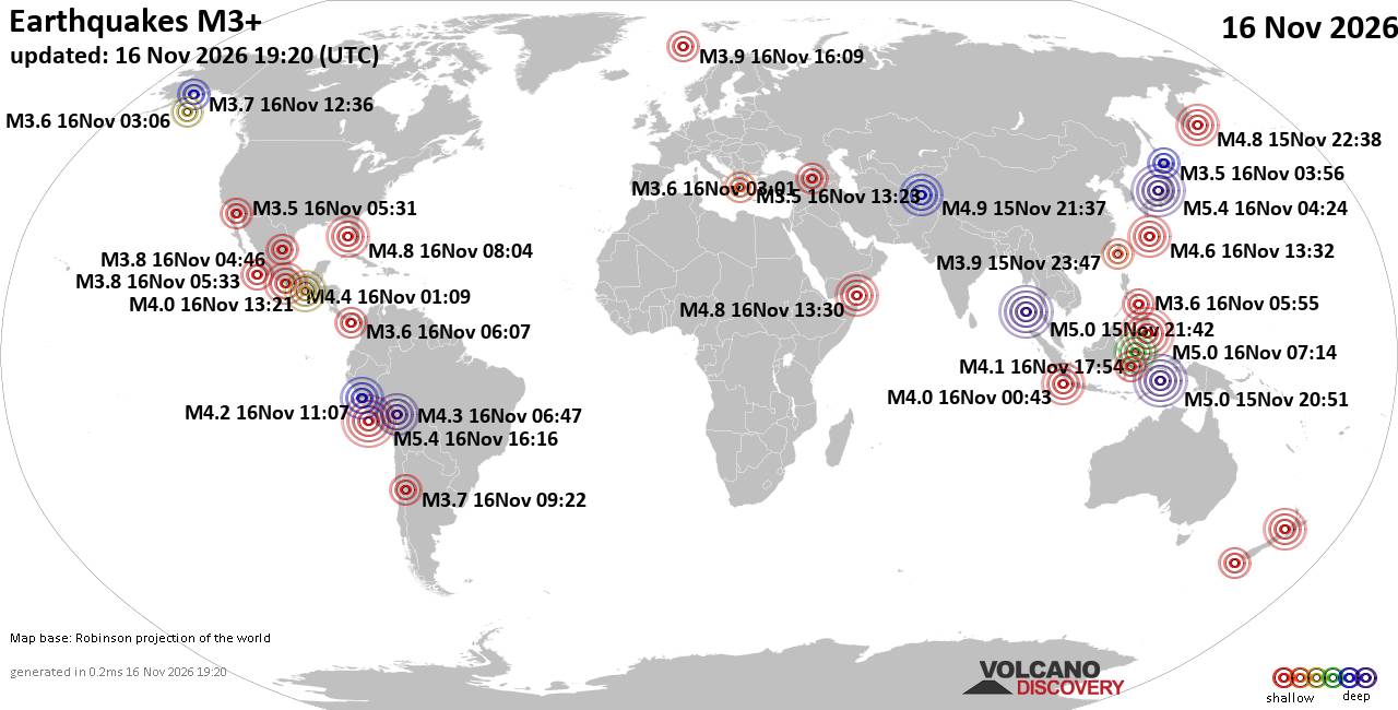
World Earthquake Report for Monday, 16 November 2026
• Moderate mag. 4.5 earthquake - 160 km northwest of Kavieng, New Ireland Pro...
• M 4.4 - off the coast of Oregon
• M 2.3 - 14 km ESE of Clam Gulch, Alaska
• M 3.9 - Rat Islands, Aleutian Islands, Alaska
• M 1.8 - 8 km NW of Round Valley, CA
• M 0.7 - 9 km S of Idyllwild, CA
|
|
|
Joined: Feb 2001
Posts: 800,656
Launch Director
|
|
Launch Director
Joined: Feb 2001
Posts: 800,656 |
Volcano earthquake report for Sunday, 15 November 2026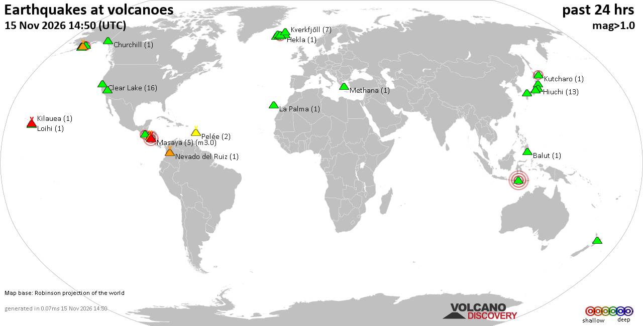 World map showing volcanoes with shallow (less than 50 km) earthquakes within 20 km radius during the past 24 hours on 15 Nov 2026 Number in brackets indicate nr of quakes. Quakes detected near: Abu (4 quakes between mag 0.5-1.6), Alaska Peninsula Arc at 155.4°W (1 quake mag 1.1), Balut (1 quake mag 1.6), Chingo (1 quake mag 2.2), Churchill (1 quake mag 1.4), Clear Lake (18 quakes between mag 0.2-1.8)
Coso (16 quakes between mag 0.7-2.2), Eldey (1 quake mag 1.0), Etna (1 quake mag 1.4), Flores (1 quake mag 1.7), Fourpeaked (1 quake mag 2.0), Grímsnes (4 quakes between mag 0.1-2.0), Hekla (1 quake mag 1.1), Hiuchi (12 quakes between mag 0.1-1.0), Katmai (2 quakes between mag 1.4-1.5), Kilauea (1 quake mag 1.8), Kurikoma (3 quakes between mag 0.3-1.3), Kutcharo (1 quake mag 2.1), Kverkfjöll (7 quakes between mag 0.1-1.3), La Palma (1 quake mag 1.9), Ljósufjöll (4 quakes between mag 0.1-1.0), Loihi (1 quake mag 2.1), Maroa (1 quake mag 1.6), Masaya (5 quakes between mag 1.9-3.0), Methana (1 quake mag 1.8), Nantai (4 quakes between mag 0.2-1.5), Nevado del Ruiz (1 quake mag 1.3), Norikura (5 quakes between mag 0.1-1.9), Novarupta (1 quake mag 1.1), Pelée (2 quakes between mag 1.0-1.0), Prestahnukur (1 quake mag 1.0), Ranakah (1 quake mag 4.4), Taupo (2 quakes between mag 0.8-1.3), Telica (1 quake mag 1.6), Tjörnes Fracture Zone (1 quake mag 1.3) (updated 12h50)\n\nNote: Earthquakes within 20 km from and at depths less than 50 km under active volcanoes are reported. The list is not complete because many volcanoes are not monitored and/or seismic data in high resolution is not available publicly.\n
Volcanoes with recent earthquakes above magnitude 2 or more than 10 quakes are listed below:
Chingo volcano (Guatemala): magnitude 2.2 earthquakeA magnitude 2.2 earthquake occurred at the volcano 13 hours ago. The quake, which might be volcanic in origin, was located at a depth of 7.00 km depth at 13 km distance WSW from the volcano. Earthquake details: 2.2 quake 25 km south of Jutiapa, Departamento de Jutiapa, Guatemala, Nov 14, 2026 05:37 pm (GMT -6) (13 km WSW) All earthquakes at ChingoChingo is a 1,775 m stratovolcano spanning the Guatemala–El Salvador border. Its last eruption is undated, and no eruption is known from approximately the past 11,700 years. Clear Lake volcano (California): 18 earthquakes up to magnitude 1.8Possible earthquake swarm: 18 earthquakes occurred near (under) the volcano during 21 hours, the last being recorded quake 3 hours ago. Hypocenter depths ranged between 3.55 and 0.32 km. Earthquake details: (only 5 largest) 1.8 quake 12 mi southwest of Clearlake, Lake County, California, United States, Nov 14, 2026 10:08 pm (GMT -8) (15 km S) 1.7 quake 12 mi southwest of Clearlake, Lake County, California, United States, Nov 14, 2026 11:09 am (GMT -8) (18 km S) 1.4 quake 28 mi north of Santa Rosa, Sonoma County, California, United States, Nov 15, 2026 01:34 am (GMT -8) (15 km SSW) 1.2 quake 29 mi north of Santa Rosa, Sonoma County, California, United States, Nov 15, 2026 12:44 am (GMT -8) (15 km SSW) 1.1 quake Lake County, 27 mi north of Santa Rosa, Sonoma County, California, United States, Nov 14, 2026 09:20 pm (GMT -8) (15 km S) All earthquakes at Clear LakeCoso volcano (California): 16 earthquakes up to magnitude 2.2Possible earthquake swarm: 16 earthquakes occurred near (under) the volcano during 15 hours, the last being recorded quake 9 hours ago. Hypocenter depths ranged between 6.45 and 3.14 km. Earthquake details: (only 5 largest) 2.2 quake Inyo County, 21 mi north of Ridgecrest, Kern County, California, United States, Nov 14, 2026 02:58 pm (GMT -8) (15 km SE) 2.1 quake Inyo County, 21 mi north of Ridgecrest, Kern County, California, United States, Nov 14, 2026 04:56 pm (GMT -8) (15 km SE) 1.9 quake Inyo County, 21 mi north of Ridgecrest, Kern County, California, United States, Nov 14, 2026 05:07 pm (GMT -8) (15 km SE) 1.8 quake Inyo County, 21 mi north of Ridgecrest, Kern County, California, United States, Nov 14, 2026 12:29 pm (GMT -8) (15 km SE) 1.7 quake Inyo County, 20 mi north of Ridgecrest, Kern County, California, United States, Nov 14, 2026 08:13 pm (GMT -8) (15 km SSE) All earthquakes at CosoCoso is a 400 km² volcanic field of rhyolitic domes, basaltic cones and lava flows east of the Sierra Nevada Range. Its youngest dated eruption occurred about 39,000 ± 33,000 years ago, while active fumaroles and thermal springs mark an important geothermal area. Hiuchi volcano (Honshu): 12 earthquakes up to magnitude 1.0Possible earthquake swarm: 12 earthquakes occurred near (under) the volcano during 23 hours, the last being recorded quake 1 hour 8 minutes ago. Hypocenter depths ranged between 9.30 and 8.00 km. Earthquake details: (only 5 largest) 1.0 quake Fukushima, 38 km northwest of Nikko, Tochigi, Japan, Nov 15, 2026 07:27 am (GMT +9) (13 km NE) 0.9 quake Japan: Western Fukushima Pref Nov 15, 2026 08:36 pm (GMT +9) (13 km NE) 0.9 quake Japan: Western Fukushima Pref Nov 15, 2026 04:44 am (GMT +9) (13 km NE) 0.9 quake Japan: Western Fukushima Pref Nov 14, 2026 09:59 pm (GMT +9) (13 km NE) 0.8 quake Japan: Western Fukushima Pref Nov 15, 2026 08:08 pm (GMT +9) (13 km NE) All earthquakes at HiuchiHiuchi is a 2,356 m stratovolcano in Japan’s Nikko National Park, distinguished by two summit lava domes overlooking Lake Ozenuma. Its last known eruption occurred at Miike-dake in 1544. Kutcharo volcano (Hokkaido): magnitude 2.1 earthquakeA magnitude 2.1 earthquake occurred at the volcano 6 hours ago. The quake, which might be volcanic in origin, was located at a depth of 0 km depth at 17 km distance WSW from the volcano. Earthquake details: 2.1 quake 40 km southeast of Kitami, Hokkaido, Japan, Nov 15, 2026 03:26 pm (GMT +9) (17 km WSW) All earthquakes at KutcharoKutcharo is a large lake-filled caldera in northeastern Hokkaido, formed by major eruptions about 340,000–30,000 years ago. Its younger Atosanupuri complex produced lava domes and explosive activity, with the last recognized eruption dated to around 1320 CE, give or take about 300 years. Loihi volcano (Hawai'i (Big Island)): magnitude 2.1 earthquakeA magnitude 2.1 earthquake occurred at the volcano 20 hours ago. The quake, which might be volcanic in origin, was located at a depth of 29.37 km depth at 17 km distance NNW from the volcano. Earthquake details: 2.1 quake North Pacific Ocean, 13 mi southeast of Pāhala, Hawaii County, Hawaii, United States, Nov 14, 2026 06:40 am (GMT -10) (17 km NNW) All earthquakes at LoihiLoihi, now named Kamaʻehuakanaloa, is a submarine shield volcano about 35 km southeast of Hawaiʻi. Its last confirmed eruption was in 1996, while later unrest has consisted of earthquake swarms without confirmed eruptions. Masaya volcano (Nicaragua): 5 earthquakes up to magnitude 3.05 earthquakes occurred near (under) the volcano during 12 hours, the last being recorded quake 26 minutes ago. Hypocenter depths ranged between 10.00 and 5.00 km. Earthquake details: Unconfirmed quake or seismic-like event reported: 10.5 km southeast of Managua, Departamento de Managua, Nicaragua, Nov 15, 2026 06:24 am (GMT -6) (8 km NNW) 2.2 quake 6.6 km north of Masaya, Departamento de Masaya, Nicaragua, Nov 15, 2026 03:55 am (GMT -6) (7 km NE) 2.0 quake 6.7 km northwest of Masaya, Departamento de Masaya, Nicaragua, Nov 15, 2026 04:10 am (GMT -6) (4 km NE) 2.0 quake Departamento de Masaya, 12 km southeast of Managua, Nicaragua, Nov 14, 2026 06:50 pm (GMT -6) (7 km NNW) 1.9 quake 5.9 km northwest of Masaya, Departamento de Masaya, Nicaragua, Nov 15, 2026 04:32 am (GMT -6) (5 km NE) All earthquakes at MasayaMasaya is a frequently active Nicaraguan volcano about 20 km southeast of Managua. Known for its intermittent lava lake, it has also produced lava flows, explosive eruptions, ashfall and prolonged gas emissions. Ranakah volcano (Flores): magnitude 4.4 earthquakeA magnitude 4.4 earthquake occurred at the volcano 3 hours ago. The quake, which might be volcanic in origin, was located at a depth of 10.00 km depth at 15 km distance ESE from the volcano. Earthquake details: 4.4 quake 23 km east of Ruteng, Kabupaten Manggarai, East Nusa Tenggara, Indonesia, Nov 15, 2026 09:24 am (GMT +0) (15 km ESE) All earthquakes at RanakahRanakah is an Indonesian lava-dome cluster where Anak Ranakah formed during the explosive and effusive eruption of 1987–89. Weak ash emissions in 1991 are its last known eruption. https://www.volcanodiscovery.com/earthquakes-volcanoes/news/413576/Volcano-earthquake-report-2026-11-15.html
|
|



CMS The Best Conveyancing solicitors conveyancing quotes throughout the UK
For any webhosting enquiries please email webmaster@aus-city.com
|
|
Entire Thread
|

 Volcano earthquake report for Sunday, 15 November 2026 |
Webmaster
|
Yesterday at 12:50 PM
|
|
Forums60
Topics930,716
Posts965,513
Members2,960
| |
Most Online102,106
Jul 10th, 2026
|
|
|
|
|

|









































