|
|
|
0 members (),
1,816
guests, and
23
robots. |
|
Key:
Admin,
Global Mod,
Mod
|
|
S |
M |
T |
W |
T |
F |
S |
|
1
|
2
|
3
|
4
|
5
|
6
|
7
|
|
8
|
9
|
10
|
11
|
12
|
13
|
14
|
|
15
|
16
|
17
|
18
|
19
|
20
|
21
|
|
22
|
23
|
24
|
25
|
26
|
27
|
28
|
|
29
|
30
|
|
|
|
|
|
|
There are no members with birthdays on this day. |
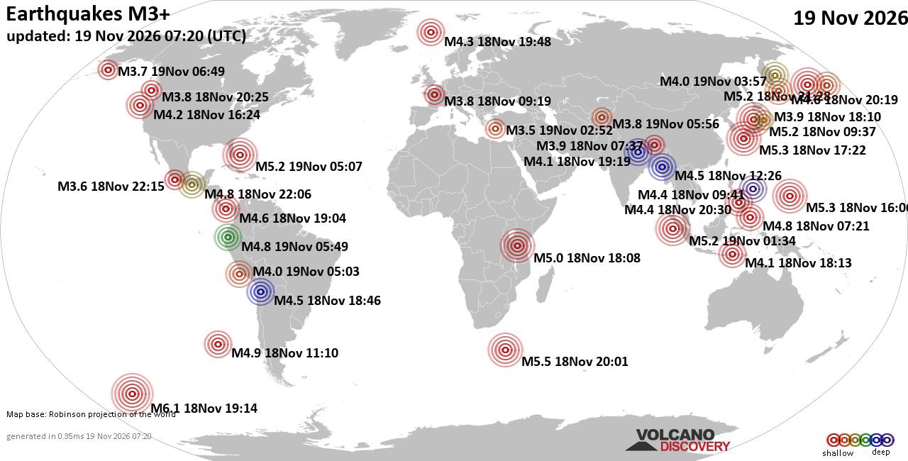
World Earthquake Report for Thursday, 19 November 2026
• M 4.4 - south of the Kermadec Islands
• M 3.4 - 18 km ENE of Borrego Springs, CA
• M 3.4 - 42 km N of Kernville, CA
• M 2.5 - 70 km S of Ugashik, Alaska
• M 2.5 - 70 km S of Ugashik, Alaska
|
|
|
Joined: Feb 2001
Posts: 800,656
Launch Director
|
|
Launch Director
Joined: Feb 2001
Posts: 800,656 |
SPC Nov 18, 2026 1930 UTC Day 3 Severe Thunderstorm OutlookSPC 1930Z Day 3 Outlook 
Day 3 Convective Outlook
NWS Storm Prediction Center Norman OK
0129 PM CST Wed Nov 18 2026

Valid 201200Z - 211200Z

...NO SEVERE THUNDERSTORM AREAS FORECAST...

...SUMMARY...
Severe storms do not appear likely Friday.

...Synopsis...
An upper trough within the Intermountain West will approach the
Rockies Friday into early Saturday. A surface trough/cold front will
develop within the High Plains. This front will eventually stretch
from the northern Plains into central Nebraska. A nebulous upper
trough will be present over parts of the Southeast into the Gulf. A
modest surface low will be present off the central Florida Atlantic
coast.

...Nebraska into South Dakota...
Some moisture return can be expected ahead of the cold front from
the afternoon into the evening/overnight. Low-level trajectories
near/over the Gulf on the preceding days will not be favorable for
northward moisture transport. That said, low 50s F dewpoints
reaching the central/northern Plains is a plausible upper-end
outcome by Friday evening. A weak signal for storm development
exists within available guidance. Given the marginal low-level
moisture and expected time of development (after 00Z), this activity
would likely be somewhat elevated. Severe potential continues to
appear rather low.

..Wendt.. 11/18/2026
Read morehttps://www.spc.noaa.gov/products/outlook/day3otlk_1930.html
|
|



CMS The Best Conveyancing solicitors conveyancing quotes throughout the UK
For any webhosting enquiries please email webmaster@aus-city.com
|
|
Entire Thread
|

 SPC Nov 18, 2026 1930 UTC Day 3 Severe Thunderstorm Outlook |
Webmaster
|
Yesterday at 07:30 PM
|
|
Forums60
Topics935,059
Posts969,856
Members2,960
| |
Most Online102,106
Jul 10th, 2026
|
|
|
|
|

|









































