|
|
|
0 members (),
1,337
guests, and
23
robots. |
|
Key:
Admin,
Global Mod,
Mod
|
|
S |
M |
T |
W |
T |
F |
S |
|
|
|
|
|
1
|
2
|
3
|
|
4
|
5
|
6
|
7
|
8
|
9
|
10
|
|
11
|
12
|
13
|
14
|
15
|
16
|
17
|
|
18
|
19
|
20
|
21
|
22
|
23
|
24
|
|
25
|
26
|
27
|
28
|
29
|
30
|
31
|
|
There are no members with birthdays on this day. |

#664947
Thu 23 Oct 2014 05:06:PM
|
Joined: Feb 2001
Posts: 381,904
Launch Director
|
OP

Launch Director
Joined: Feb 2001
Posts: 381,904 |
A New Perspective on U.S. Great Lakes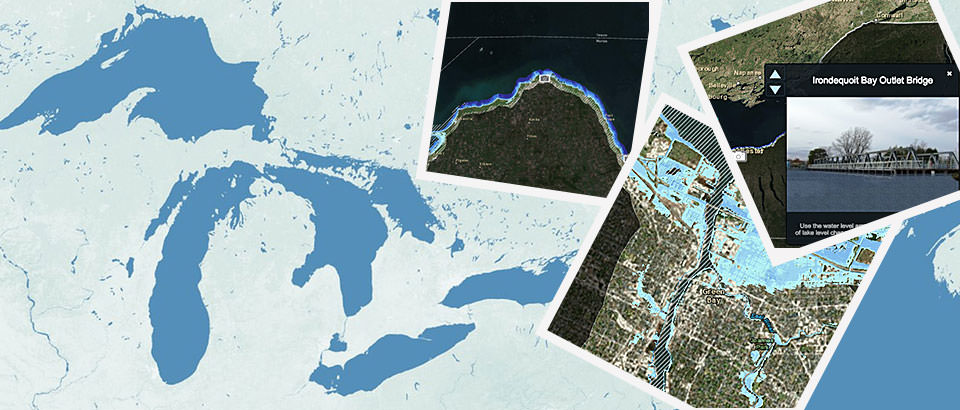 Any geography student who's viewed a map of the United States has surely marveled at the vast expanse of the nation's Great Lakes, which contain nearly 20 percent of the Earth's surface water. To stand on the shore of any one of these freshwater inland seas--Superior, Michigan, Huron, Erie, or Ontario--is to gaze across boundless waters to a distant horizon. Now, NOAA's Office for Coastal Management provides another perspective on these impressive water bodies with its new Lake Level Viewer for the U.S. Great Lakes. Continue reading → https://oceanservice.noaa.gov/news/oct14/lake-level-viewer.html
|
|


CMS The Best Conveyancing solicitors conveyancing quotes throughout the UK
For any webhosting enquiries please email webmaster@aus-city.com
|
|
Forums60
Topics759,041
Posts793,755
Members2,958
| |
Most Online17,963
Jan 15th, 2026
|
|
|
|
|
Copyright 1996 - 2026 by David Cottle. Designed by David Bate Jr. All Rights Reserved.
By using this forum, the user agrees not to transfer any data or technical information received under the agreement, to any other entity without the express approval of the AUS-CITY Forum Admins and/or authors of individual posts (Forum Admins and DoD/USSPACECOM for the analysis of satellite tracking data).
Two-line elements (TLE) and all other satellite data presented and distributed via this forum and e-mail lists of AUS-CITY are distributed with permission from DoD/USSTRATCOM.

Reprise Hosting

|

|


 - Click image for larger picture.")


