|
0 members (),
1,872
guests, and
35
robots. |
|
Key:
Admin,
Global Mod,
Mod
|
|
S |
M |
T |
W |
T |
F |
S |
|
|
|
|
1
|
2
|
3
|
4
|
|
5
|
6
|
7
|
8
|
9
|
10
|
11
|
|
12
|
13
|
14
|
15
|
16
|
17
|
18
|
|
19
|
20
|
21
|
22
|
23
|
24
|
25
|
|
26
|
27
|
28
|
29
|
30
|
31
|
|
|
There are no members with birthdays on this day. |
|
|
|
|
|
|
|
|
|
|
|
|
|
|
|
|
|
|
|
|
|
|
by Webmaster - Tue 14 Jul 2026 10:01:PM
|

Volcano earthquake report for Friday, 10 Jul 2026
• Moderate mag. 4.2 earthquake - 133 km northwest of Ternate, Kota Ternate, N...
• World Earthquake Report for Friday, 10 July 2026
• Moderate mag. 4.6 earthquake - 17 km southwest of Comalapa, Estado de Chiap...
• Moderate mag. 4.1 earthquake - Olyutorskiy Rayon, 47 km northwest of Tilich...
• Moderate mag. 4.0 earthquake - Hawke's Bay, New Zealand, on Saturday, Jul 1...
|

#718421
Tue 09 Apr 2024 04:15:AM
|
Joined: Feb 2001
Posts: 678,976
Launch Director
|
OP

Launch Director
Joined: Feb 2001
Posts: 678,976 |
SPC Tornado Watch 92WW 92 TORNADO LA TX 090050Z - 090600Z 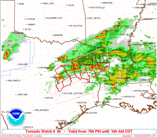
URGENT - IMMEDIATE BROADCAST REQUESTED
Tornado Watch Number 92
NWS Storm Prediction Center Norman OK
750 PM CDT Mon Apr 8 2024

The NWS Storm Prediction Center has issued a

* Tornado Watch for portions of
  Northwest Louisiana
  East Texas

* Effective this Monday night and Tuesday morning from 750 PM
  until 100 AM CDT.

* Primary threats include...
  A few tornadoes likely
  Scattered large hail likely with isolated very large hail events
    to 2 inches in diameter possible
  Scattered damaging wind gusts to 70 mph likely

SUMMARY...Thunderstorms will continue to affect parts of east Texas
and northwest Louisiana for several more hours this evening.
Strengthening low-level winds suggest a continued risk of isolated
supercells and an attendant threat of tornadoes.

The tornado watch area is approximately along and 50 statute miles
north and south of a line from 35 miles south southwest of Corsicana
TX to 60 miles east northeast of Shreveport LA. For a complete
depiction of the watch see the associated watch outline update
(WOUS64 KWNS WOU2).

PRECAUTIONARY/PREPAREDNESS ACTIONS...

REMEMBER...A Tornado Watch means conditions are favorable for
tornadoes and severe thunderstorms in and close to the watch
area. Persons in these areas should be on the lookout for
threatening weather conditions and listen for later statements
and possible warnings.

&&

OTHER WATCH INFORMATION...CONTINUE...WW 90...WW 91...

AVIATION...Tornadoes and a few severe thunderstorms with hail
surface and aloft to 2 inches. Extreme turbulence and surface wind
gusts to 60 knots. A few cumulonimbi with maximum tops to 500. Mean
storm motion vector 25030.

...Hart
Read morehttps://www.spc.noaa.gov/products/watch/ww0092.html
|
|


CMS The Best Conveyancing solicitors conveyancing quotes throughout the UK
For any webhosting enquiries please email webmaster@aus-city.com
|
|
Forums60
Topics788,789
Posts823,564
Members2,960
| |
Most Online102,106
Jul 10th, 2026
|
|
|


 - Click image for larger picture.")


