|
|
|
0 members (),
1,076
guests, and
16
robots. |
|
Key:
Admin,
Global Mod,
Mod
|
|
S |
M |
T |
W |
T |
F |
S |
|
|
|
|
|
|
|
1
|
|
2
|
3
|
4
|
5
|
6
|
7
|
8
|
|
9
|
10
|
11
|
12
|
13
|
14
|
15
|
|
16
|
17
|
18
|
19
|
20
|
21
|
22
|
|
23
|
24
|
25
|
26
|
27
|
28
|
29
|
|
30
|
31
|
|
|
|
|
|
|
There are no members with birthdays on this day. |
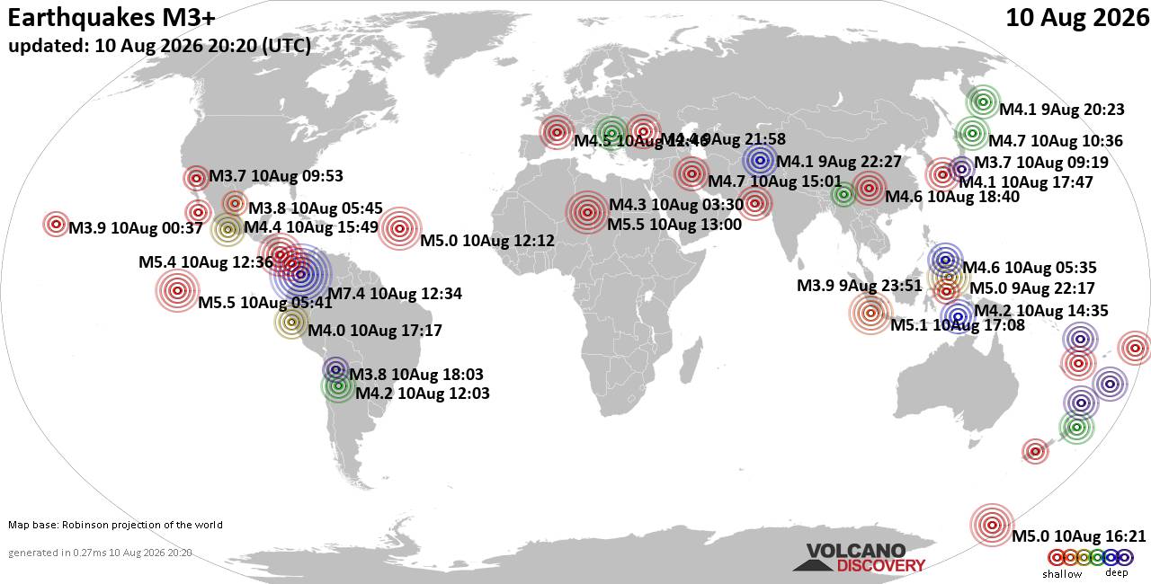
World Earthquake Report for Monday, 10 August 2026
• Volcano earthquake report for Monday, 10 Aug 2026
• Moderate mag. 4.0 earthquake - Zangilan Rayon, 58 km southwest of Ganja, Ga...
• Moderate mag. 4.6 earthquake - 31 km northeast of Xunchang, Sichuan, China,...
• Moderate mag. 4.2 earthquake - New Zealand on Tuesday, Aug 11, 2026, at 06:...
• World Earthquake Report for August 2026
|

#726676
Sat 22 Jun 2024 12:10:PM
|
Joined: Feb 2001
Posts: 678,976
Launch Director
|
OP

Launch Director
Joined: Feb 2001
Posts: 678,976 |
SPC Jun 22, 2024 1300 UTC Day 1 Convective OutlookSPC 1300Z Day 1 Outlook 
Day 1 Convective Outlook
NWS Storm Prediction Center Norman OK
0706 AM CDT Sat Jun 22 2024

Valid 221300Z - 231200Z

...THERE IS A SLIGHT RISK OF SEVERE THUNDERSTORMS ACROSS PARTS OF
THE MIDWEST/GREAT LAKES...

...SUMMARY...
Severe thunderstorms are possible this afternoon and evening across
parts of the Midwest and Great Lakes region, including potential for
damaging winds as well as a risk for tornadoes.

...Midwest/Upper Mississippi Valley and Upper Great Lakes...
Ongoing scattered showers/thunderstorms near/south of the synoptic
front complicates the later-day scenario to a degree, but
outflow/air mass modification is expected into the afternoon with
moderate to locally strong destabilization. This will be also
coincident with a modestly amplifying shortwave trough/speed max
over the Upper Mississippi Valley toward the Lake Michigan vicinity.
This belt of 30-50 kt of west-southwesterly flow in the 850-500 mb
layer is expected to overspread a destabilizing environment, with
stronger insolation/destabilization most probable across eastern
Iowa into northern Illinois by mid/late afternoon.

Surface-based severe storm development including supercells will
become probable by mid/late afternoon in vicinity of the modestly
deepening surface low and triple point, including parts of
northeast/east-central Iowa into far southern Wisconsin and northern
Illinois. These storms will pose a tornado risk aside from more
probable wind damage, which will increase as storms progress
southeastward and also potentially expand southwestward somewhat
along the southeastward-moving cold front this evening.

...Northern Mid-Atlantic States/Northeast...
Deep-layer wind fields and shear are likely to remain weak, but
moderately large CAPE (in excess of 2000 J/kg) may once again
develop within weak surface troughing, along and southwest of the
remnant surface frontal zone. It appears that this will become
supportive of scattered strong thunderstorms with the potential to
produce damaging wind gusts and possibly a few instances of hail.

...Northern Plains...
Stronger mid/upper forcing for ascent and mid-level cooling are
likely to remain north of the international border through and
beyond peak daytime heating, but isolated severe storms could
develop mainly across North Dakota by this evening, accompanied by a
risk for marginally severe hail and/or wind.

...Southern Arizona...
A few pulse-type strong/locally severe storms may occur this
afternoon through early evening within a relatively moist and
moderately environment across parts of south-central/southeast
Arizona, with downbursts/strong wind gusts as the primary risk.

...Eastern Utah/western Colorado...
While not expected to be nearly as active as Friday, a few strong
storms could occur regionally, with strong wind gusts/some hail
possible on a very isolated basis.

..Guyer/Mosier.. 06/22/2024
Read morehttps://www.spc.noaa.gov/products/outlook/day1otlk_1300.html
|
|



CMS The Best Conveyancing solicitors conveyancing quotes throughout the UK
For any webhosting enquiries please email webmaster@aus-city.com
|
|
Forums60
Topics796,363
Posts831,153
Members2,960
| |
Most Online102,106
Jul 10th, 2026
|
|
|
|
|

|





































