|
|
|
0 members (),
958
guests, and
20
robots. |
|
Key:
Admin,
Global Mod,
Mod
|
|
S |
M |
T |
W |
T |
F |
S |
|
|
|
|
|
|
|
1
|
|
2
|
3
|
4
|
5
|
6
|
7
|
8
|
|
9
|
10
|
11
|
12
|
13
|
14
|
15
|
|
16
|
17
|
18
|
19
|
20
|
21
|
22
|
|
23
|
24
|
25
|
26
|
27
|
28
|
29
|
|
30
|
|
|
|
|
|
|
|
There are no members with birthdays on this day. |

#740853
Wed 09 Oct 2024 06:13:AM
|
Joined: Feb 2001
Posts: 381,904
Launch Director
|
OP

Launch Director
Joined: Feb 2001
Posts: 381,904 |
Small magnitude 3.6 quake hits 18 km southeast of Mexicali, Mexico late at night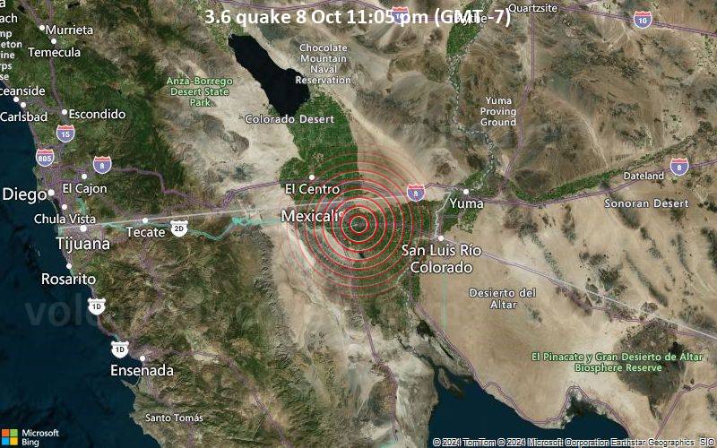 3.6 quake 8 Oct 11:05 pm (GMT -7) An earthquake of magnitude 3.6 occurred only 6 minutes ago 18 km southeast of Mexicali, Mexico, the United States Geological Survey reported.
The quake hit at a shallow depth of 21.2 km beneath the epicenter near Mexicali, Mexicali Municipality, Baja California, Mexico, late at night on Tuesday, October 8th, 2024, at 11:05 pm local time. The exact magnitude, epicenter, and depth of the quake might be revised within the next few hours or minutes as seismologists review data and refine their calculations, or as other agencies issue their report.
Our monitoring service identified a second report from The Incorporated Research Institutions for Seismology (IRIS) which listed the quake at magnitude 3.6 as well. A third agency, the European-Mediterranean Seismological Centre (EMSC), reported the same quake at magnitude 3.5.
Towns or cities near the epicenter where the quake might have been felt as very weak shaking include Sinaloa (pop. 2,500) located 2 km from the epicenter, Puebla (pop. 15,200) 6 km away, Mexicali (pop. 1,032,700) 18 km away, Calexico (pop. 40,100) 24 km away, Progreso (pop. 12,600) 28 km away, Santa Isabel (pop. 29,300) 28 km away, Guadalupe Victoria (pop. 17,100) 34 km away, El Centro (pop. 44,000) 37 km away, San Luis (pop. 31,500) 48 km away, and San Luis Rio Colorado (pop. 158,100) 50 km away.
Earthquake data: Date & time: Oct 8, 2024 11:05 pm (Tijuana time) local time (9 Oct 2024 06:05 GMT)Magnitude: 3.6 Depth: 21.2 km Epicenter latitude / longitude: 32.56°N / 115.29°W  ( Mexicali, Baja California, Mexico) Primary data source: USGShttps://www.volcanodiscovery.com/earthquake/news/254503/Small-magnitude-36-quake-hits-18-km-southeast-of-Mexicali-Mexico-late-at-night-.html
|
|


CMS The Best Conveyancing solicitors conveyancing quotes throughout the UK
For any webhosting enquiries please email webmaster@aus-city.com
|
|
Forums60
Topics746,609
Posts781,263
Members2,958
| |
Most Online4,158
Jun 21st, 2024
|
|
|
|
|
Copyright 1996 - 2024 by David Cottle. Designed by David Bate Jr. All Rights Reserved.
By using this forum, the user agrees not to transfer any data or technical information received under the agreement, to any other entity without the express approval of the AUS-CITY Forum Admins and/or authors of individual posts (Forum Admins and DoD/USSPACECOM for the analysis of satellite tracking data).
Two-line elements (TLE) and all other satellite data presented and distributed via this forum and e-mail lists of AUS-CITY are distributed with permission from DoD/USSTRATCOM.

Reprise Hosting

|

|


 - Click image for larger picture.")


